Addison (village), New York facts for kids
Quick facts for kids
Addison, New York
|
|
|---|---|
|
Village
|
|

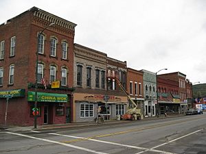
Downtown Addison
|
|
| Country | United States |
| State | New York |
| County | Steuben |
| Area | |
| • Total | 1.89 sq mi (4.90 km2) |
| • Land | 1.89 sq mi (4.90 km2) |
| • Water | 0.00 sq mi (0.00 km2) |
| Elevation | 997 ft (304 m) |
| Population
(2020)
|
|
| • Total | 1,561 |
| • Density | 824.62/sq mi (318.42/km2) |
| Time zone | UTC-5 (Eastern (EST)) |
| • Summer (DST) | UTC-4 (EDT) |
| ZIP code |
14801
|
| Area code(s) | 607 |
| FIPS code | 36-00276 |
| GNIS feature ID | 0942177 |
Addison is a small village located in Steuben County, New York, in the United States. It is found in the southeastern part of the town of the same name. The village is southwest of the city of Corning. In 2020, about 1,561 people lived there. Both the village and the surrounding town are named after a famous writer, Joseph Addison.
Contents
Village History
Addison became an official village for the first time in 1854. It was then re-established as a village in 1873.
Addison's Role in the Civil War
During the American Civil War, a group of soldiers known as Company E of the 34th New York Volunteer Infantry Regiment was mainly formed here. Many people from Addison joined this group to serve their country.
Historic Buildings in Addison
Several important buildings in Addison are listed on the National Register of Historic Places. This means they are recognized for their special history and architecture. These include the Addison Village Hall, the Church of the Redeemer, and the William Wombough House. Also, two areas, the Main Street Historic District and the Maple Street Historic District, are recognized as historic places.
Geography of Addison
Addison is located at 42°6′28″N 77°13′56″W / 42.10778°N 77.23222°W. The village covers a total area of about 1.9 square miles (4.9 square kilometers), and all of it is land.
Roads and Rivers
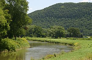
Several important roads pass through Addison, including Steuben County Route 119 (which used to be New York State Route 432) and New York State Route 417. Other county roads, like County Roads 1 and 5, also run through the village. The Tuscarora Creek flows into the Canisteo River right in the village. East of Addison, you can find Pinnacle State Park and Golf Course, a great place for outdoor activities. Addison is part of the Southern Tier region of New York.
Train Lines
Addison is on a major train line that goes from New Jersey to Buffalo. This line is used by the Norfolk Southern Railway and also by Canadian Pacific Railway trains. This railway has been around since 1850 and has had many different names over the years, like the Erie Railroad and Conrail.
From 1882 to 1961, Addison also had another train line called the Wellsville, Addison & Galeton Railroad. This line was eventually closed in 1961 to encourage more travel by road.
Climate in Addison
| Climate data for the village of Addison, New York, 1991–2020 normals, extremes 1893–2020 | |||||||||||||
|---|---|---|---|---|---|---|---|---|---|---|---|---|---|
| Month | Jan | Feb | Mar | Apr | May | Jun | Jul | Aug | Sep | Oct | Nov | Dec | Year |
| Record high °F (°C) | 74 (23) |
73 (23) |
85 (29) |
92 (33) |
98 (37) |
100 (38) |
106 (41) |
103 (39) |
103 (39) |
99 (37) |
84 (29) |
71 (22) |
106 (41) |
| Mean daily maximum °F (°C) | 33.1 (0.6) |
35.8 (2.1) |
44.0 (6.7) |
57.5 (14.2) |
69.6 (20.9) |
77.9 (25.5) |
82.0 (27.8) |
80.8 (27.1) |
73.7 (23.2) |
61.5 (16.4) |
48.7 (9.3) |
38.0 (3.3) |
58.6 (14.8) |
| Daily mean °F (°C) | 23.5 (−4.7) |
25.0 (−3.9) |
32.5 (0.3) |
44.3 (6.8) |
55.5 (13.1) |
64.6 (18.1) |
69.1 (20.6) |
67.8 (19.9) |
60.5 (15.8) |
49.2 (9.6) |
38.2 (3.4) |
29.5 (−1.4) |
46.6 (8.1) |
| Mean daily minimum °F (°C) | 13.8 (−10.1) |
14.1 (−9.9) |
21.1 (−6.1) |
31.1 (−0.5) |
41.3 (5.2) |
51.3 (10.7) |
56.2 (13.4) |
54.8 (12.7) |
47.4 (8.6) |
37.0 (2.8) |
27.6 (−2.4) |
21.0 (−6.1) |
34.7 (1.5) |
| Record low °F (°C) | −35 (−37) |
−28 (−33) |
−22 (−30) |
1 (−17) |
18 (−8) |
16 (−9) |
34 (1) |
34 (1) |
24 (−4) |
10 (−12) |
−4 (−20) |
−26 (−32) |
−35 (−37) |
| Average precipitation inches (mm) | 1.80 (46) |
1.61 (41) |
2.52 (64) |
3.34 (85) |
3.55 (90) |
3.19 (81) |
4.22 (107) |
3.55 (90) |
3.66 (93) |
3.81 (97) |
2.54 (65) |
2.26 (57) |
36.05 (916) |
| Average snowfall inches (cm) | 13.3 (34) |
11.8 (30) |
9.6 (24) |
1.0 (2.5) |
0.1 (0.25) |
0.0 (0.0) |
0.0 (0.0) |
0.0 (0.0) |
0.0 (0.0) |
0.3 (0.76) |
2.1 (5.3) |
10.0 (25) |
48.2 (121.81) |
| Average precipitation days (≥ 0.01 in) | 13.7 | 10.9 | 13.8 | 14.4 | 15.3 | 13.9 | 11.7 | 11.9 | 11.4 | 15.1 | 13.6 | 14.9 | 160.6 |
| Average snowy days (≥ 0.1 in) | 10.0 | 8.0 | 5.8 | 1.0 | 0.1 | 0.0 | 0.0 | 0.0 | 0.0 | 0.1 | 2.4 | 8.0 | 35.4 |
| Source 1: NOAA | |||||||||||||
| Source 2: National Weather Service | |||||||||||||
Population Information
| Historical population | |||
|---|---|---|---|
| Census | Pop. | %± | |
| 1880 | 1,596 | — | |
| 1890 | 2,166 | 35.7% | |
| 1900 | 2,080 | −4.0% | |
| 1910 | 2,004 | −3.7% | |
| 1920 | 1,699 | −15.2% | |
| 1930 | 1,538 | −9.5% | |
| 1940 | 1,617 | 5.1% | |
| 1950 | 1,920 | 18.7% | |
| 1960 | 2,185 | 13.8% | |
| 1970 | 2,104 | −3.7% | |
| 1980 | 2,028 | −3.6% | |
| 1990 | 1,842 | −9.2% | |
| 2000 | 1,797 | −2.4% | |
| 2010 | 1,763 | −1.9% | |
| 2020 | 1,561 | −11.5% | |
| U.S. Decennial Census | |||
According to the census from 2000, Addison had 1,797 people living in 724 households. About 33.3% of these households had children under 18. The average household had 2.48 people.
The population was spread out, with 27.4% of people under 18 years old. About 14.9% of the population was 65 years or older. The average age in the village was 36 years.
See also
 In Spanish: Addison (villa) para niños
 | Jessica Watkins |
 | Robert Henry Lawrence Jr. |
 | Mae Jemison |
 | Sian Proctor |
 | Guion Bluford |


