Chemung County, New York facts for kids
Quick facts for kids
Chemung County
|
||
|---|---|---|
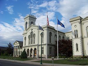
Chemung County Courthouse
|
||
|
||
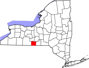
Location within the U.S. state of New York
|
||
 New York's location within the U.S. |
||
| Country | ||
| State | ||
| Founded | March 29, 1836 | |
| Named for | Unami for "big horn" | |
| Seat | Elmira | |
| Largest city | Elmira | |
| Area | ||
| • Total | 411 sq mi (1,060 km2) | |
| • Land | 407 sq mi (1,050 km2) | |
| • Water | 3.4 sq mi (9 km2) 0.8% | |
| Population
(2020)
|
||
| • Total | 84,148 | |
| • Density | 206.6/sq mi (79.8/km2) | |
| Time zone | UTC−5 (Eastern) | |
| • Summer (DST) | UTC−4 (EDT) | |
| Congressional district | 23rd | |
Chemung County is a county in New York State. About 84,148 people lived here in 2020. Its main city and county seat is Elmira. The name "Chemung" comes from a Native American word that means "big horn." This county is part of the "Southern Tier" region of New York.
Chemung County is also part of the Elmira, NY Metropolitan Statistical Area. This area is sometimes called "Mark Twain Country." That's because the famous author Mark Twain lived and wrote in Elmira for many years.
Contents
Exploring Chemung County's Past
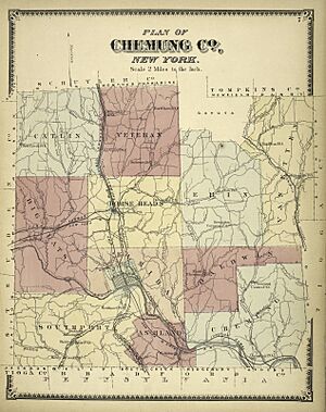
Chemung County was created in 1836. It was formed from a part of Tioga County. At first, it was about 520 square miles big.
Later, in 1854, a piece of Chemung County was used to create Schuyler County. This made Chemung County smaller, about 410 square miles. That's its size today!
Discovering Chemung County's Location
Chemung County is in the southwestern part of New York State. It shares a border with Pennsylvania. This area is known as the Southern Tier of New York. It's also part of the beautiful Finger Lakes Region.
The county has a total area of 411 square miles. Most of this is land, about 407 square miles. The rest, about 3.4 square miles, is water.
The Southern Tier Expressway is a major road that goes through the county. It runs from east to west. You can find it near the Pennsylvania border. It connects towns like Waverly and Corning through Elmira.
Getting Around Chemung County
Major Roads
Airport Access
- Elmira Corning Regional Airport is the main airport for the area.
People of Chemung County
| Historical population | |||
|---|---|---|---|
| Census | Pop. | %± | |
| 1840 | 20,732 | — | |
| 1850 | 28,821 | 39.0% | |
| 1860 | 26,917 | −6.6% | |
| 1870 | 35,281 | 31.1% | |
| 1880 | 43,065 | 22.1% | |
| 1890 | 48,265 | 12.1% | |
| 1900 | 54,063 | 12.0% | |
| 1910 | 54,662 | 1.1% | |
| 1920 | 65,872 | 20.5% | |
| 1930 | 74,680 | 13.4% | |
| 1940 | 73,718 | −1.3% | |
| 1950 | 86,827 | 17.8% | |
| 1960 | 98,706 | 13.7% | |
| 1970 | 101,537 | 2.9% | |
| 1980 | 97,656 | −3.8% | |
| 1990 | 95,195 | −2.5% | |
| 2000 | 91,070 | −4.3% | |
| 2010 | 88,830 | −2.5% | |
| 2020 | 84,148 | −5.3% | |
| U.S. Decennial Census 1790-1960 1900-1990 1990-2000 2010-2020 |
|||
Who Lives Here? (2020 Census)
| Race | Number of People | Percentage |
|---|---|---|
| White (not Hispanic) | 69,559 | 82.66% |
| Black or African American (not Hispanic) | 5,009 | 5.95% |
| Native American (not Hispanic) | 198 | 0.23% |
| Asian (not Hispanic) | 1,426 | 1.69% |
| Pacific Islander (not Hispanic) | 15 | 0.02% |
| Other/Mixed (not Hispanic) | 5,003 | 5.95% |
| Hispanic or Latino | 2,938 | 3.49% |
Learning in Chemung County
Students in Chemung County have many choices for education. There are public and private schools. High school students and adults can also go to GST BOCES. BOCES offers special training for jobs and adult classes.
Public School Districts
Here are some of the public school districts that serve Chemung County:
- Corning City School District
- Elmira City School District
- Elmira Heights Central School District
- Horseheads Central School District
- Odessa-Montour Central School District
- Spencer-Van Etten Central School District
- Watkins Glen Central School District
- Waverly Central School District
Private Schools
- Chemung Valley Montessori School
- Elmira Christian Academy
- Holy Family Middle School
- Saint Mary Our Mother School
- Notre Dame High School
- Twin Tiers Christian Academy
Colleges and Higher Learning
- Arnot Ogden School of Nursing
- Corning Community College (has sites in the area)
- Elmira College
- Elmira Business Institute
Public Libraries
Chemung County Library District
- Steele Memorial Library
- Horseheads Free Library
- Big Flats Library
- West Elmira Library
- Van Etten Library
- Chemung County Bookmobile
Communities in Chemung County
Larger Towns and Villages
| # | Location | Population | Type | Area |
|---|---|---|---|---|
| 1 | †Elmira | 29,200 | City | Elmira-Horseheads |
| 2 | Southport | 7,238 | CDP | Elmira-Horseheads |
| 3 | Horseheads | 6,461 | Village | Elmira-Horseheads |
| 4 | Big Flats | 5,277 | CDP | West |
| 5 | West Elmira | 4,967 | CDP | Elmira-Horseheads |
| 6 | Elmira Heights | 4,097 | Village | Elmira-Horseheads |
| 7 | Horseheads North | 2,843 | CDP | North |
| 8 | Pine Valley | 813 | CDP | North |
| 9 | Breesport | 626 | CDP/Hamlet | Northeast |
| 10 | Wellsburg | 580 | Village | Southeast |
| 11 | ††Van Etten | 537 | CDP/Hamlet | Northeast |
| 12 | Erin | 483 | CDP | Northeast |
| 13 | Millport | 312 | Village | North |
† - County Seat (main city)
†† - Used to be a village
Towns in the County
Hamlet (Small Community)
See also
 In Spanish: Condado de Chemung para niños
 | Chris Smalls |
 | Fred Hampton |
 | Ralph Abernathy |


