Ashland, Chemung County, New York facts for kids
Quick facts for kids
Ashland, New York
|
|
|---|---|

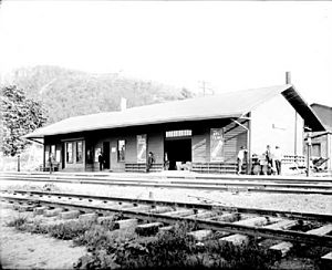
Wellsburg, the main village in Ashland
|
|
| Country | United States |
| State | New York |
| County | Chemung |
| Government | |
| • Type | Town Council |
| Area | |
| • Total | 14.54 sq mi (37.65 km2) |
| • Land | 14.18 sq mi (36.73 km2) |
| • Water | 0.36 sq mi (0.92 km2) |
| Elevation | 827 ft (252 m) |
| Population
(2020)
|
|
| • Total | 1,515 |
| • Estimate
(2021)
|
1,487 |
| • Density | 113.38/sq mi (43.78/km2) |
| Time zone | UTC-5 (Eastern (EST)) |
| • Summer (DST) | UTC-4 (EDT) |
| ZIP code |
14894 (Wellsburg)
|
| FIPS code | 36-02781 |
| GNIS feature ID | 0978691 |
Ashland is a small town located in Chemung County, New York, in the United States. In 2020, about 1,515 people lived there. The town got its name from "Ashland," which was the home of a famous American statesman named Henry Clay.
Ashland is found on the southern edge of Chemung County, just south of the city of Elmira. It is part of the larger Elmira area.
Contents
History of Ashland
Early Events and Settlement
A very important event happened in the northern part of Ashland in 1779. This was the Battle of Newtown. It was part of a larger military action called the Sullivan Expedition.
The first people to settle in this area arrived around 1788. The town of Ashland itself was officially created much later, in 1867. It was formed by taking parts from three nearby towns: Chemung, Elmira, and Southport.
How Ashland Got Its Name
When the town was being formed, the people who founded it wanted to name it after a well-known local citizen, R.C. Lockwood. However, he suggested the name "Ashland" instead. This name was inspired by the home of Henry Clay, a famous American politician. Ashland was the very last town to be created in Chemung County.
Geography of Ashland
Land and Water
Ashland covers a total area of about 37.7 square kilometers (about 14.5 square miles). Most of this area is land, around 36.7 square kilometers (14.18 square miles). The rest, about 0.9 square kilometers (0.36 square miles), is water.
The Chemung River flows through the town. This river is a branch of the larger Susquehanna River. The southern border of Ashland is also the border with the state of Pennsylvania.
Major Roads and Highways
Several important roads pass through Ashland. These include Interstate 86 (which is also New York State Route 17), New York State Route 14, and New York State Route 427. There is also a shorter state highway, New York State Route 367, located near the village of Wellsburg.
Population and People
| Historical population | |||
|---|---|---|---|
| Census | Pop. | %± | |
| 1870 | 1,558 | — | |
| 1880 | 1,149 | −26.3% | |
| 1890 | 983 | −14.4% | |
| 1900 | 954 | −3.0% | |
| 1910 | 769 | −19.4% | |
| 1920 | 834 | 8.5% | |
| 1930 | 948 | 13.7% | |
| 1940 | 951 | 0.3% | |
| 1950 | 1,188 | 24.9% | |
| 1960 | 1,273 | 7.2% | |
| 1970 | 1,726 | 35.6% | |
| 1980 | 1,967 | 14.0% | |
| 1990 | 1,966 | −0.1% | |
| 2000 | 1,951 | −0.8% | |
| 2010 | 1,695 | −13.1% | |
| 2020 | 1,515 | −10.6% | |
| 2021 (est.) | 1,487 | −12.3% | |
| U.S. Decennial Census | |||
Population Changes Over Time
The population of Ashland has changed quite a bit over the years. For example, in 1870, there were 1,558 people living in the town. By 2020, the population was 1,515. You can see how the number of people has gone up and down in the chart next to this section.
Who Lives in Ashland
According to the census from 2000, there were 1,951 people living in Ashland. Most of the people living in Ashland were White. A small number of people were African American, Native American, or Asian. Some people also identified as being from two or more races, or as Hispanic or Latino.
There were 785 households in the town. About 28% of these households had children under 18 living with them. The average household had about 2.48 people.
Communities and Locations in Ashland
- Baldwin Island – This is an island located in the Chemung River, north of Wellsburg.
- Big Island – Another island in the Chemung River, found northwest of Baldwin Island.
- Comfort Hill – A noticeable hill on the western side of the town.
- Lowman – This is a small community, or hamlet, that is partly in Ashland. It's north of the Chemung River, near where NY-17 meets County Road 8.
- Newtown Battlefield Reservation – This is the historic site where the Battle of Newtown took place. It's in the northern part of the town, close to the Chemung River.
- Wellsburg – This is the main village in Ashland. It is located close to the Pennsylvania border. The village is named after an early settler, Abner Wells.
See also
 In Spanish: Ashland (condado de Chemung, Nueva York) para niños
 | Victor J. Glover |
 | Yvonne Cagle |
 | Jeanette Epps |
 | Bernard A. Harris Jr. |


