Horseheads, New York facts for kids
Quick facts for kids
Horseheads, New York
|
|
|---|---|

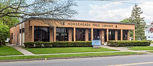
Horseheads Public Library
|
|
| Country | United States |
| State | New York |
| County | Chemung |
| Government | |
| • Type | Town Council |
| Area | |
| • Total | 35.92 sq mi (93.03 km2) |
| • Land | 35.61 sq mi (92.22 km2) |
| • Water | 0.31 sq mi (0.81 km2) |
| Elevation | 1,178 ft (359 m) |
| Population
(2020)
|
|
| • Total | 19,412 |
| • Estimate
(2021)
|
19,069 |
| • Density | 544.66/sq mi (210.29/km2) |
| Time zone | UTC-5 (Eastern (EST)) |
| • Summer (DST) | UTC-4 (EDT) |
| FIPS code | 36-015-35705 |
| GNIS feature ID | 979080 |
Horseheads is a town in Chemung County, New York, United States. About 19,412 people lived here in 2020. The town's unique name comes from a time when many bleached horse skulls were found in the area.
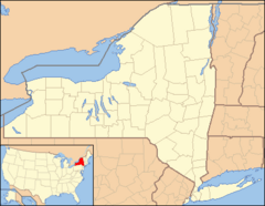
Horseheads is located north of the city of Elmira. There is also a village called Horseheads inside the town. It is part of the larger Elmira area.
Contents
History of Horseheads
The Story Behind the Name
In 1779, during the American Revolutionary War, General John Sullivan led his troops on a long journey through the wilderness. They marched from Pennsylvania into what is now New York, aiming to raid Native American villages allied with the British.
The journey was very tough on the soldiers and their horses. They didn't have enough food, and many horses became sick or too tired to continue. About six miles north of Fort Reid, on September 24, 1779, the soldiers had to leave behind many of their sick horses.
There were so many horses left that their skulls were very noticeable. The local Iroquois people collected these skulls and arranged them in a line along the trail. From then on, this spot was known as the "valley of the horses' heads." This is how the town of Horseheads got its name!
Early Settlers and Growth
The first settlers arrived in the Horseheads area around 1787. This made it one of the first places in Chemung County to be settled. The town of Horseheads was officially formed in 1835 from parts of the towns of Elmira and Chemung. The village of Horseheads, which was then called Fairport, became its own official village in 1837.
The Great Fire of 1862
In August 1862, a large fire swept through Horseheads. It destroyed much of the town's business area.
The Holding Point During World War II
In the northern part of Horseheads, there was a special area called The Holding Point. The United States government used it during World War II. It was a huge storage and collection place for military equipment. Over 700 acres were used to store supplies for the war effort. About 30 soldiers and 500 civilians worked there. For a short time, German prisoners of war helped with labor, followed by Italian service units who were loyal to the Allies.
Where is Horseheads?
Horseheads covers an area of about 93 square kilometers (about 36 square miles). Most of this is land, with a small amount of water.
Newtown Creek, a small river that flows into the Chemung River, runs through the middle of the town. Major highways like Interstate 86 and New York State Route 17 (also known as the Southern Tier Expressway) pass through Horseheads. These roads help people travel east and west. Other important roads like New York State Route 13 and New York State Route 14 run north and south. Horseheads is located in the Southern Tier region of New York State.
Population Facts
| Historical population | ||
|---|---|---|
| Year | Pop. | ±% |
| 1860 | 2,277 | — |
| 1870 | 2,961 | +30.0% |
| 1880 | 3,449 | +16.5% |
| 1890 | 3,482 | +1.0% |
| 1900 | 4,944 | +42.0% |
| 1910 | 5,376 | +8.7% |
| 1920 | 6,809 | +26.7% |
| 1930 | 8,420 | +23.7% |
| 1940 | 8,804 | +4.6% |
| 1950 | 11,118 | +26.3% |
| 1960 | 17,808 | +60.2% |
| 1970 | 20,552 | +15.4% |
| 1980 | 20,238 | −1.5% |
| 1990 | 19,926 | −1.5% |
| 2000 | 19,561 | −1.8% |
| 2010 | 19,485 | −0.4% |
| 2021 | 19,069 | −2.1% |
| * Population estimate. 1890-1990: Source from Chemung County, not Census Bureau. |
||
In 2000, there were 19,561 people living in Horseheads. Most people were White, but there were also African American, Asian, and Native American residents. About 0.74% of the population was Hispanic or Latino.
The average family size was about three people. The median age in the town was 41 years old. This means half the people were older than 41 and half were younger.
Getting Around Horseheads
In the past, a railway called the Elmira & Seneca Lake Railway opened in 1900, connecting Horseheads to Seneca Lake. The old Chemung Canal also used to pass through the town.
Today, Interstate 86 and New York State Route 17 are main roads that help people travel to nearby cities like Elmira and Corning. You can also get to Watkins Glen and Ithaca using other state routes.
The Elmira Corning Regional Airport is close by, even though its mailing address says "Horseheads, NY." It's actually located in the nearby town of Big Flats, New York. There is also bus service through C-Tran.
Schools in Horseheads
Most of the schools in Horseheads are part of the Horseheads Central School District. A small part of the town in the southwest is served by the Elmira Heights Central School District.
Sister City Connection
Since 1990, Horseheads has had a "sister city" relationship with a town in Japan. This means they are friendly towns that exchange visitors and ideas. The original sister city was Bato, Japan, which also means "Horseheads" in Japanese!
In 2005, Bato merged with another town to form a new town called Nakagawa. Nakagawa continued the sister city tradition. Students and adults from both towns still visit each other to learn about different cultures.
Neighborhoods and Places
Here are some of the communities and locations you can find in the Town of Horseheads:
- Breesport – A small community on the eastern side of town.
- Elmira Heights – A village that is mostly within the town of Horseheads, north of Elmira.
- Elmira Heights North – A neighborhood that is a suburb of Elmira.
- Horseheads – The main village within the town, located on NY-17.
- Horseheads North – A special area in the northern part of the town.
- Orchard Knoll – A community southeast of Horseheads village.
- Ormiston – A place south of Breesport.
- Slabtown – A location near the northern border of the town.
See also
 In Spanish: Horseheads (pueblo) para niños
 | Selma Burke |
 | Pauline Powell Burns |
 | Frederick J. Brown |
 | Robert Blackburn |


