Horseheads (village), New York facts for kids
Quick facts for kids
Horseheads, New York
|
|
|---|---|
|
Village
|
|

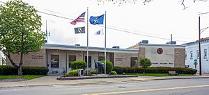
Horseheads Village Hall and Police Station
|
|
| Country | United States |
| State | New York |
| County | Chemung |
| Town | Horseheads |
| Area | |
| • Total | 3.91 sq mi (10.12 km2) |
| • Land | 3.89 sq mi (10.08 km2) |
| • Water | 0.01 sq mi (0.04 km2) |
| Elevation | 896 ft (273 m) |
| Population
(2020)
|
|
| • Total | 6,606 |
| • Density | 1,696.89/sq mi (655.09/km2) |
| Time zone | UTC-5 (Eastern (EST)) |
| • Summer (DST) | UTC-4 (EDT) |
| ZIP codes |
14844-14845
|
| Area code(s) | 607 |
| FIPS code | 36-35694 |
| GNIS feature ID | 0953232 |
Horseheads is a village located in Chemung County, New York, United States. In 2020, about 6,606 people lived there. The village gets its unique name from a historical event involving many horses.
Horseheads village is part of the larger town of Horseheads. It is situated north of the city of Elmira. The area is part of what is called the Elmira Metropolitan Statistical Area, which means it's a region with a central city and surrounding communities that are closely connected.
Contents
History of Horseheads
How Horseheads Got Its Name
The name "Horseheads" comes from an event that happened in September 1779. During the American Revolution, American forces led by General John Sullivan marched through this area. They were on a mission against Loyalists and their Iroquois allies.
The journey was very hard on their horses. Many horses became sick or too weak to continue. When the soldiers reached a spot about 6 miles north of Fort Reid, they had to leave behind a large number of these horses. The Iroquois people later found the bones of these horses. They collected the skulls and arranged them in a line along the trail.
Because of this, the area became known as the "Valley of the Horses' Heads." This name stuck, and it's how the village of Horseheads got its name. Today, stone markers show the path of Sullivan's troops and the locations of Iroquois villages they visited.
Early Settlement and Name Changes
People started settling in the Horseheads area around 1830. The village was officially recognized in 1839. At first, it was called "Fairport" because it was located on the Chemung Canal. Canals were like water highways for boats carrying goods.
However, in 1845, the village changed its name back to "Horseheads." Later, in 1885, it was briefly renamed "North Elmira." But the very next year, in 1886, the village went back to its original and most famous name, "Horseheads."
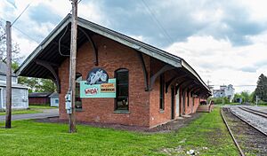
Several important places in Horseheads are listed on the National Register of Historic Places. These include the Chemung Railway Depot, Hanover Square Historic District, Horseheads 1855 Extension Historic District, Teal Park, and Zimmerman House. These places help preserve the village's history.
Building High-Speed Rail Cars
Horseheads is becoming a place where new technology is being built. A company called Siemens Mobility has chosen Horseheads to build a factory. This factory will make high-speed rail cars for the Brightline West train. This train will connect Los Angeles to Las Vegas.
The factory will be about 300,000 square feet and cost $60 million to build. The goal is for the Brightline West train to start service by 2028, using rail cars made right here in Horseheads. This project marks the beginning of a new industry in the United States.
Geography of Horseheads
Horseheads village is located in the Southern Tier Region of New York. It is about 5 miles north of downtown Elmira. The village sits at a low point on a special line called the Eastern Continental Divide. This divide separates rivers that flow south to the Atlantic Ocean from rivers that flow north to the Great Lakes.
For example, Newtown Creek, on the east side of the village, flows south towards the Chemung River. The Chemung River is a branch of the Susquehanna River. However, the northern part of the village drains north into Catharine Creek. This creek flows into Seneca Lake, which is one of the famous Finger Lakes.
The village covers a total area of about 3.9 square miles (10.1 square kilometers). Only a very small part of this area, about 0.01 square miles (0.04 square kilometers), is water.
Major roads pass through Horseheads, making it easy to travel to and from the village. These include New York State Route 17 and Interstate 86. New York State Route 14, which runs north and south, also crosses State Route 17 in the village. Another important road, New York State Route 13, meets State Route 17 just east of the village.
Population and People
The population of Horseheads has changed over the years. Here's a look at how many people have lived in the village during different census years:
- 1870: 1,410 people
- 1880: 1,684 people
- 1890: 1,716 people
- 1900: 1,901 people
- 1910: 1,778 people
- 1920: 2,078 people
- 1930: 2,430 people
- 1940: 2,570 people
- 1950: 3,606 people
- 1960: 7,207 people
- 1970: 7,989 people
- 1980: 7,348 people
- 1990: 6,802 people
- 2000: 6,452 people
- 2010: 6,461 people
- 2020: 6,606 people
According to the 2000 census, there were 6,452 people living in Horseheads. These people lived in 2,862 households, and 1,800 of these were families. The village had about 1,666 people per square mile.
Most of the people in the village were White (95.57%). There were also smaller groups of African American (1.30%), Asian (1.92%), and Native American (0.12%) residents. About 0.91% of the population identified as Hispanic or Latino.
In terms of age, about 22.6% of the population was under 18 years old. About 21.0% were 65 years or older. The average age in the village was 41 years old. For every 100 females, there were about 86.6 males.
The average income for a household in the village was $35,915. For families, the average income was $44,971. About 8.8% of the total population lived below the poverty line. This included 10.9% of those under 18 and 5.6% of those 65 or older.
Education in Horseheads
The public schools in Horseheads village are part of the Horseheads Central School District. This district is responsible for educating the children and teenagers living in the area.
See also
 In Spanish: Horseheads (villa) para niños
 | Jewel Prestage |
 | Ella Baker |
 | Fannie Lou Hamer |


