Howard, New York facts for kids
Quick facts for kids
Howard, New York
|
|
|---|---|

Howard, New York
|
|
| Country | United States |
| State | New York |
| County | Steuben |
| Area | |
| • Total | 60.77 sq mi (157.38 km2) |
| • Land | 60.55 sq mi (156.81 km2) |
| • Water | 0.22 sq mi (0.57 km2) |
| Elevation | 1,588 ft (484 m) |
| Population
(2020)
|
|
| • Total | 1,380 |
| • Estimate
(2021)
|
1,367 |
| • Density | 23.40/sq mi (9.04/km2) |
| Time zone | UTC-5 (Eastern (EST)) |
| • Summer (DST) | UTC-4 (EDT) |
| FIPS code | 36-35837 |
| GNIS feature ID | 0979082 |
Howard is a small town located in Steuben County, New York, in the United States. In 2020, about 1,380 people lived there.
The Town of Howard is found in the west-central part of Steuben County. It is located just east of the city of Hornell.
Contents
History of Howard
People first started settling in the area around 1803. The town of Howard was officially created in 1812. It was formed using parts of two other towns: Bath and Dansville. Later, Howard also gave up some of its land to help create new towns. These new towns were Avoca in 1843 and Fremont in 1854.
Geography and Nature
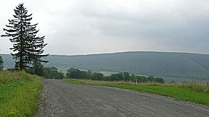
The town of Howard covers a total area of about 60.7 square miles (157.38 square kilometers). Most of this area is land, with only a small part being water.
A major highway, Interstate 86, runs through the northern half of the town. There is an exit, Exit 35, located right in Howard. You can also find a part of the famous Finger Lakes Trail here, which is a long hiking trail.
Population and People
| Historical population | |||
|---|---|---|---|
| Census | Pop. | %± | |
| 1820 | 1,140 | — | |
| 1830 | 2,463 | 116.1% | |
| 1840 | 3,247 | 31.8% | |
| 1850 | 3,244 | −0.1% | |
| 1860 | 2,746 | −15.4% | |
| 1870 | 2,122 | −22.7% | |
| 1880 | 2,131 | 0.4% | |
| 1890 | 1,938 | −9.1% | |
| 1900 | 1,704 | −12.1% | |
| 1910 | 1,461 | −14.3% | |
| 1920 | 1,127 | −22.9% | |
| 1930 | 1,032 | −8.4% | |
| 1940 | 893 | −13.5% | |
| 1950 | 902 | 1.0% | |
| 1960 | 929 | 3.0% | |
| 1970 | 1,029 | 10.8% | |
| 1980 | 1,236 | 20.1% | |
| 1990 | 1,331 | 7.7% | |
| 2000 | 1,430 | 7.4% | |
| 2010 | 1,467 | 2.6% | |
| 2020 | 1,380 | −5.9% | |
| 2021 (est.) | 1,367 | −6.8% | |
| U.S. Decennial Census | |||
In 2010, the town of Howard had 1,467 people living there. The population density was about 23.6 people per square mile. There were 788 homes in the town.
Many households in Howard had children under 18 living with them. Most families were married couples. The average household had about 2.81 people. The average family had about 3.13 people.
The population was spread out across different age groups. About 30.5% of the people were under 18 years old. About 10.7% were 65 years or older. The average age in Howard was 36 years.
Education in Howard
Students in Howard attend schools in different nearby districts. These include the school districts of Avoca, Bath, Canisteo-Greenwood, and Hornell.
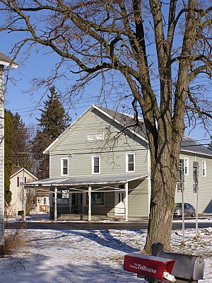
In the past, Howard had its own schools. One old school building was made of cobblestone. It was a unique building, but it fell apart in 2004 and was taken down. Another old schoolhouse is still standing today. It is now used as a store that sells heating equipment. You can easily spot this building near the Interstate-86 entrance and exit ramps.
Communities and Places
Here are some of the smaller communities and interesting places you can find in the Town of Howard:
- Buena Vista – A small village, called a hamlet, located near the southern border of the town.
- Butchers Corners – Another hamlet found on the western edge of the town.
- Goff's Mills – This used to be a community in the northeastern part of Howard.
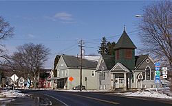
- Howard – This is the main hamlet of Howard, located near Interstate 86.
- Lake Demon – Also known as Demons Pond, this is a small lake between the hamlet of Howard and Towlesville. It's pronounced like "lemon."
- Stephens Creek – A stream that flows out of the southwestern part of the town.
- Towlesville – A hamlet located in the southeastern part of the town.
See also
 In Spanish: Howard (Nueva York) para niños
 | Sharif Bey |
 | Hale Woodruff |
 | Richmond Barthé |
 | Purvis Young |


