Ontario County, New York facts for kids
Ontario County is a county located in the U.S. State of New York. In 2020, about 112,458 people lived here. The main town, or county seat, is Canandaigua. Ontario County is part of the beautiful Finger Lakes region in New York.
Quick facts for kids
Ontario County
|
|||
|---|---|---|---|

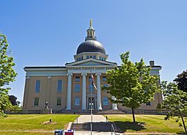
Ontario County Courthouse in Canandaigua, 2014
|
|||
|
|||

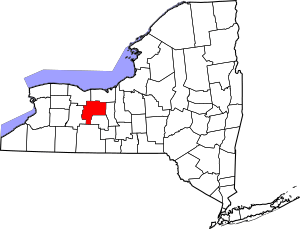
Location within the U.S. state of New York
|
|||
 New York's location within the U.S. |
|||
| Country | |||
| State | |||
| Founded | 1789 | ||
| Named for | Lake Ontario | ||
| Seat | Canandaigua | ||
| Largest city | Geneva | ||
| Area | |||
| • Total | 663 sq mi (1,720 km2) | ||
| • Land | 644 sq mi (1,670 km2) | ||
| • Water | 18 sq mi (50 km2) 2.8% | ||
| Population
(2020)
|
|||
| • Total | 112,458 | ||
| • Density | 169/sq mi (65/km2) | ||
| Time zone | UTC−5 (Eastern) | ||
| • Summer (DST) | UTC−4 (EDT) | ||
| Congressional district | 24th | ||
Ontario County is also part of the larger Rochester area. In 2006, a magazine called Progressive Farmer named Ontario County the "Best Place to Live" in the U.S. They liked its good schools, low crime, great health care, and its closeness to Rochester.
Contents
History of Ontario County
This land was originally home to the Seneca people. They were one of the Five Nations of the Iroquois Confederacy, also known as the Haudenosaunee. After the American Revolutionary War, they had to give up most of their land to the United States.
When the English first created counties in New York in 1683, Albany County was huge. It covered most of northern New York and even parts of what is now Vermont. However, the Iroquois people actually controlled much of central and western New York until after the Revolutionary War.
After the war, many settlers from New England moved into western New York. Millions of acres of new land became available. This was because the Iroquois tribes, who had sided with the British, had to give up their lands.
Ontario County officially became a county in 1789. It was formed from the lands of the Phelps and Gorham Purchase. At first, Ontario County was much larger than it is today. It stretched south from Lake Ontario. As more people settled, new counties were created from its territory.
Over the years, many new counties were formed from parts of Ontario County. These included Allegany, Cattaraugus, Chautauqua, Erie, Genesee, Livingston, Monroe, Niagara, Orleans, Steuben, Wyoming, and Yates counties. Parts of Schuyler and Wayne counties were also formed from this area.
Religious Movements and History
This area was important during the Second Great Awakening in the early 1800s. This was a time when many religious revivals happened. Preachers from different churches, like Baptist and Methodist, traveled around. They held large meetings to share their beliefs. New religious groups also started in this part of New York.
The Latter Day Saint Movement
Joseph Smith, who started the Latter Day Saint movement, lived in Manchester in the 1820s. This town is right on the border with Palmyra. Many important events in the early history of his movement happened in Ontario County.
One key place is Hill Cumorah in Manchester. Joseph Smith said he found the Golden plates there. These plates contained the writings that later became the Book of Mormon. Smith said he visited the hill every year on September 22nd from 1823 to 1827. He claimed an Angel Moroni gave him instructions. He finally took the plates on September 22, 1827. The Book of Mormon was published in Palmyra in 1830.
The hill is about 110 feet (34 meters) tall. It is located on the main road between Palmyra and Canandaigua (now State Route 21). It was only a few miles from Joseph Smith's home.
Since the 1930s, the Church of Jesus Christ of Latter-day Saints has held a large outdoor play called the Hill Cumorah Pageant here every year. Thousands of people come to watch it. The church also has a visitors' center at the hill. They also maintain the Palmyra New York Temple and Joseph Smith's former property. This property is on the border of Ontario and Wayne counties.
Geography of Ontario County
Ontario County covers a total area of 663 square miles (1,717 square kilometers). About 644 square miles (1,668 square kilometers) is land, and 18 square miles (47 square kilometers) is water.
The county is in western New York State. It is located east of Buffalo, southeast of Rochester, and northwest of Ithaca. As mentioned, it is part of the beautiful Finger Lakes Region.
Neighboring Counties
Ontario County shares borders with several other counties:
- Wayne County - to the north
- Seneca County - to the east
- Yates County - to the south
- Steuben County - to the southwest
- Livingston County - to the west
- Monroe County - to the northwest
Main Roads and Highways

 Interstate 90 (New York State Thruway)
 Interstate 490
 U.S. Route 20
 U.S. Route 20A
 New York State Route 5
 New York State Route 14
 New York State Route 14A
 New York State Route 15A
 New York State Route 21
 New York State Route 31
 New York State Route 53
 New York State Route 64
 New York State Route 65
 New York State Route 88
 New York State Route 96
 New York State Route 245
 New York State Route 247
 New York State Route 251
 New York State Route 318
 New York State Route 332
 New York State Route 364
 New York State Route 444
 New York State Route 488
Economy and Agriculture
Ontario County has a strong farming community. In 2022, it was ranked fourth in New York State for the number of acres used to grow berries. Farmers in the county reported growing berries on 220 acres that year.
Population and People
| Historical population | |||
|---|---|---|---|
| Census | Pop. | %± | |
| 1790 | 1,075 | — | |
| 1800 | 15,218 | 1,315.6% | |
| 1810 | 42,032 | 176.2% | |
| 1820 | 88,267 | 110.0% | |
| 1830 | 40,288 | −54.4% | |
| 1840 | 43,501 | 8.0% | |
| 1850 | 43,929 | 1.0% | |
| 1860 | 44,563 | 1.4% | |
| 1870 | 45,108 | 1.2% | |
| 1880 | 49,541 | 9.8% | |
| 1890 | 48,453 | −2.2% | |
| 1900 | 49,605 | 2.4% | |
| 1910 | 52,286 | 5.4% | |
| 1920 | 52,652 | 0.7% | |
| 1930 | 54,276 | 3.1% | |
| 1940 | 55,307 | 1.9% | |
| 1950 | 60,172 | 8.8% | |
| 1960 | 68,070 | 13.1% | |
| 1970 | 78,849 | 15.8% | |
| 1980 | 88,909 | 12.8% | |
| 1990 | 95,101 | 7.0% | |
| 2000 | 100,224 | 5.4% | |
| 2010 | 108,085 | 7.8% | |
| 2020 | 112,458 | 4.0% | |
| U.S. Decennial Census 1790-1960 1900-1990 1990-2000 2010-2020 |
|||
In 2000, there were 100,224 people living in Ontario County. These people lived in 38,370 households, with 26,360 being families. The population density was about 156 people per square mile.
Most people in the county identified as White (95.04%). Other groups included African American (2.06%), Native American (0.22%), and Asian (0.69%). About 2.14% of the population identified as Hispanic or Latino.
The average household had 2.53 people, and the average family had 3.03 people. About 32.80% of households had children under 18 living with them. The median age in the county was 38 years old.
The median income for a household was $44,579. For families, the median income was $52,698. About 7.30% of all people, including 9.10% of those under 18, lived below the poverty line.
2020 Census Data
| Race | Num. | Perc. |
|---|---|---|
| White (NH) | 97,397 | 86.61% |
| Black or African American (NH) | 2,439 | 2.2% |
| Native American (NH) | 197 | 0.2% |
| Asian (NH) | 1,374 | 1.2% |
| Pacific Islander (NH) | 23 | 0.02% |
| Other/Mixed (NH) | 4,915 | 4.4% |
| Hispanic or Latino | 6,113 | 5.43% |
Communities in Ontario County
Ontario County has several cities, towns, and villages.
Larger Settlements
| # | Location | Population | Type | Sector |
|---|---|---|---|---|
| 1 | ‡Geneva | 13,261 | City | East |
| 2 | †Canandaigua | 10,545 | City | West |
| 3 | Victor | 2,696 | Village | West |
| 4 | Clifton Springs | 2,127 | Village | East |
| 5 | Phelps | 1,989 | Village | East |
| 6 | Manchester | 1,709 | Village | East |
| 7 | Shortsville | 1,439 | Village | East |
| 8 | Bloomfield | 1,361 | Village | West |
| 9 | Naples | 1,041 | Village | South |
| 10 | ‡Rushville | 655 | Village | East |
| 11 | Crystal Beach | 644 | Hamlet | East |
| 12 | Honeoye | 579 | CDP | South |
| 13 | Port Gibson | 453 | CDP | East |
| 14 | Hall | 216 | CDP | East |
| - | Gorham | N/A | CDP | East |
† - County Seat
‡ - Not Wholly in this County
Towns in Ontario County
Hamlets in Ontario County
- Border City
- Centerfield
- Cheshire
- Fishers
- Hall
- Hopewell Center
- Ionia
- Orleans
- Seneca Castle
- Stanley
See also
 In Spanish: Condado de Ontario (Nueva York) para niños
 | Jessica Watkins |
 | Robert Henry Lawrence Jr. |
 | Mae Jemison |
 | Sian Proctor |
 | Guion Bluford |


