Wyoming County, New York facts for kids
Quick facts for kids
Wyoming County
|
|||
|---|---|---|---|

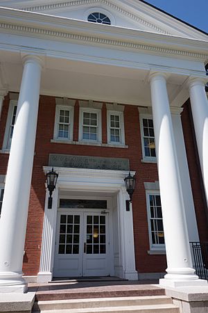
Old Wyoming County Courthouse
|
|||
|
|||

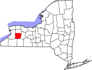
Location within the U.S. state of New York
|
|||
 New York's location within the U.S. |
|||
| Country | |||
| State | |||
| Founded | 1841 | ||
| Seat | Warsaw | ||
| Largest village | Warsaw | ||
| Area | |||
| • Total | 596 sq mi (1,540 km2) | ||
| • Land | 593 sq mi (1,540 km2) | ||
| • Water | 3.5 sq mi (9 km2) 0.6% | ||
| Population
(2020)
|
|||
| • Total | 40,531 | ||
| • Density | 68.4/sq mi (26.4/km2) | ||
| Time zone | UTC−5 (Eastern) | ||
| • Summer (DST) | UTC−4 (EDT) | ||
| Congressional district | 24th | ||
Wyoming County is a county in the U.S. state of New York. It's located in the western part of the state. In 2020, about 40,531 people lived there. The main town, or county seat, is Warsaw.
The name "Wyoming" comes from a Lenape (Native American) word. It means "broad bottom lands." Wyoming County was created in 1841 from Genesee County. It's known for its farms. There are more dairy cows in Wyoming County than people! The county is also part of the beautiful Finger Lakes region.
Contents
Exploring Wyoming County's Past
Like other parts of Western New York, Wyoming County was once claimed by many groups. In the 1600s and 1700s, the Massachusetts Bay Colony, Connecticut Colony, Pennsylvania Colony, New York Colony, and New France all wanted this land. New York's claim was finally accepted in 1786. This happened with the Treaty of Hartford.
In 1683, the area that is now Wyoming County was part of a huge area called Albany County. This county covered much of New York State and even parts of what is now Vermont. Over time, this large county was divided into smaller ones.
In 1772, Albany County was split into three parts. One new part was Tryon County. This county included the western lands, stretching far to the west. After the American Revolutionary War, Tryon County was renamed Montgomery County. This honored General Richard Montgomery, a hero of the war.
Later, in 1789, Ontario County was formed from Montgomery County.
Most of the land west of the Genesee River, including Wyoming County, was bought in 1793. This was called the Holland Purchase. Land was then sold to settlers starting in 1801.
Genesee County was created in 1802 from Ontario County. It was made to manage the land from the Holland Purchase. Genesee County was also very large at first. It was made smaller over the years as new counties were formed.
Finally, in 1841, Wyoming County was officially created. It was formed from parts of Genesee County, Allegany County, and Cattaraugus County.
Wyoming County's Landscape
Wyoming County covers about 596 square miles. Most of this is land, with a small amount of water. It's located in western New York State. It is east of Buffalo and southwest of Rochester. This area is part of the Holland Purchase Region.
The county is mostly rural, meaning it has lots of open land and small towns. Even Warsaw, the county seat, is a small town. The land is generally hilly and has fertile soil. Many areas are covered in forests. These forests are used for timber. Some maple trees are tapped each spring to make delicious maple syrup.
Agriculture is a very important part of the county's economy. Farming is a big business here. The area is also great for outdoor activities. People enjoy fishing, hunting, and snowmobiling.
There is a geologic fault that runs through the Dale valley. This fault can cause small earthquakes sometimes. The Dale Valley also has salt deposits. Salt is taken from the ground here to be used in the chemical industry. A pipeline carries this salt to Niagara Falls.
The Genesee River forms part of the county's southeastern border. Other smaller streams, like Tonawanda and Buffalo creeks, also flow through the county. Oatka Creek, an important stream that flows into the Genesee River, starts in the Town of Gainesville in Wyoming County.
Neighboring Counties
- Genesee County - north
- Livingston County - east
- Allegany County - south
- Cattaraugus County - southwest
- Erie County - west
Main Roads in Wyoming County
 U.S. Route 20A
 New York State Route 19
 New York State Route 19A
 New York State Route 39
 New York State Route 63
 New York State Route 77
 New York State Route 78
 New York State Route 98
 New York State Route 238
 New York State Route 246
 New York State Route 354
 New York State Route 362
 New York State Route 436
People of Wyoming County
| Historical population | |||
|---|---|---|---|
| Census | Pop. | %± | |
| 1850 | 31,981 | — | |
| 1860 | 31,968 | 0.0% | |
| 1870 | 29,164 | −8.8% | |
| 1880 | 30,907 | 6.0% | |
| 1890 | 31,193 | 0.9% | |
| 1900 | 30,413 | −2.5% | |
| 1910 | 31,880 | 4.8% | |
| 1920 | 30,314 | −4.9% | |
| 1930 | 28,764 | −5.1% | |
| 1940 | 31,394 | 9.1% | |
| 1950 | 32,822 | 4.5% | |
| 1960 | 34,793 | 6.0% | |
| 1970 | 37,688 | 8.3% | |
| 1980 | 39,895 | 5.9% | |
| 1990 | 42,507 | 6.5% | |
| 2000 | 43,424 | 2.2% | |
| 2010 | 42,155 | −2.9% | |
| 2020 | 40,531 | −3.9% | |
| U.S. Decennial Census 1790-1960 1900-1990 1990-2000 2010-2020 |
|||
In 2000, there were 43,424 people living in Wyoming County. Most residents were White (91.84%). About 5.52% were Black or African American. People from many backgrounds live here. Some common ancestries include German, English, Irish, Polish, and Italian.
The average age in the county was 37 years old. About 24.10% of the population was under 18. The median household income was about $39,895.
2020 Census Update
| Race | Num. | Perc. |
|---|---|---|
| White (NH) | 35,579 | 87.8% |
| Black or African American (NH) | 1,852 | 4.6% |
| Native American (NH) | 83 | 0.2% |
| Asian (NH) | 217 | 0.54% |
| Pacific Islander (NH) | 6 | .01% |
| Other/Mixed (NH) | 1,304 | 3.22% |
| Hispanic or Latino | 1,490 | 3.7% |
Fun Places to Visit in Wyoming County
- Letchworth State Park: This amazing park is on the Genesee River. It has a deep gorge and three big waterfalls. It's a beautiful and historic place. It was formed when a glacier changed the river's path. This park was home to Mary Jemison, known as the White Woman of the Genesee.
- Middlebury Academy: Located in Wyoming village, this was the first high school west of the Genesee River. The old building is still there and is a historic landmark.
- Hillside Inn: This inn opened around 1841 as a spa. It had mineral springs on a hill above Wyoming village. Many important people have stayed here, including Theodore Roosevelt and Susan B. Anthony.
- Arcade and Attica Railroad: You can ride a restored steam locomotive here! It's a fun way to experience history.
- Attica maximum security prison: This prison is located in the northern part of the county.
- Bliss Wind Farm: This farm in Eagle uses wind turbines to create electricity.
- Gaslight Village: Downtown Wyoming village has historic gas street lamps. Natural gas and salt deposits have been important to the area's economy.
- Silver Lake: This small glacial lake is unique. It's the only one of the Finger Lakes that is west of the Genesee River.
- Morton Salt: One of the largest salt mines in the Northeast is in Silver Springs. It has been operating since the mid-to-late 1800s.
Communities in Wyoming County
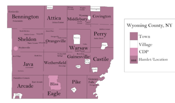
Bigger Towns and Villages
| # | Location | Population | Type | Sector |
|---|---|---|---|---|
| 2 | Perry | 3,536 | Village | Northeast |
| 1 | †Warsaw | 3,646 | Village | Northeast |
| 3 | ‡Attica | 2,547 | Village | Northwest |
| 4 | Arcade | 2,071 | Village | Southwest |
| 5 | Castile | 1,015 | Village | Southeast |
| 6 | Silver Springs | 782 | Village | Southeast |
| 7 | Strykersville | 647 | CDP | Northwest |
| 8 | Bliss | 527 | CDP | Southwest |
| 9 | Wyoming | 434 | Village | Northeast |
| 10 | Pike | 371 | Hamlet/CDP | Southeast |
| 11 | Gainesville | 304 | Village | Southeast |
Towns in Wyoming County
Small Villages (Hamlets)
- North Java
- Portageville
- Silver Lake
Schools in Wyoming County
Here are some of the school districts that serve Wyoming County:
- Alden Central School District
- Alexander Central School District
- Attica Central School District
- Dalton-Nunda Central School District (Keshequa)
- Fillmore Central School District
- Holland Central School District
- Iroquois Central School District
- Letchworth Central School District
- Pavilion Central School District
- Perry Central School District
- Warsaw Central School District
- Wyoming Central School District
- York Central School District
- Yorkshire-Pioneer Central School District
Famous People from Wyoming County
- James H. Agen (1847–1921): A Wisconsin State Assemblyman.
- Joseph M. Bailey (1833–1895): Born in Middlebury, he became a Chief Justice of the Illinois Supreme Court.
- Daniel F. Bakeman: The last surviving soldier from the American Revolutionary War. He and his wife, Susan, are known for having one of the longest marriages on record.
- Calvin Fairbank (1816–1898): Born in what is now Wyoming County, he was a Methodist minister and a strong supporter of ending slavery.
- Ed Don George (1905–1985): Born in North Java, he was a professional wrestler and a naval commander.
- John Victor Skiff (1908–1964): Born in Gainesville, he was an environmental conservationist and public servant.
- David Starr Jordan (1851–1931): Born in Gainesville, he was a fish expert (ichthyologist), educator, and peace activist.
- Barber Conable: Born in Warsaw, he was a U.S. Representative and a former head of the World Bank.
- Chester A. Arthur: A U.S. President who lived for a time in Perry.
- Thomas Aquinas Daly (born 1937): An artist who lives in Arcade.
- Ray Witter (1896–1983): An American football player.
See also
 In Spanish: Condado de Wyoming (Nueva York) para niños
 | Janet Taylor Pickett |
 | Synthia Saint James |
 | Howardena Pindell |
 | Faith Ringgold |


