Genesee Falls, New York facts for kids
Quick facts for kids
Genesee Falls, New York
|
|
|---|---|

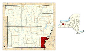
Location within Wyoming County and New York
|
|
| Country | United States |
| State | New York |
| County | Wyoming |
| Area | |
| • Total | 15.70 sq mi (40.66 km2) |
| • Land | 15.62 sq mi (40.44 km2) |
| • Water | 0.09 sq mi (0.22 km2) |
| Elevation | 1,434 ft (437 m) |
| Population
(2010)
|
|
| • Total | 438 |
| • Estimate
(2016)
|
423 |
| • Density | 27.09/sq mi (10.46/km2) |
| Time zone | UTC-5 (Eastern (EST)) |
| • Summer (DST) | UTC-4 (EDT) |
| FIPS code | 36-28596 |
| GNIS feature ID | 0978990 |
Genesee Falls is a small town in Wyoming County, New York. It is an official "town" within the state's system. In 2010, about 438 people lived there.
The Town of Genesee Falls is located in the southeastern corner of Wyoming County.
Contents
History of Genesee Falls
The Town of Genesee Falls was created in 1846. It was formed from parts of two other towns. These were the Town of Pike and the Town of Portage. The Town of Portage was in Livingston County.
In 1876, a very strong storm hit the area of Portageville. It caused damage to buildings and injured some people.
Where is Genesee Falls?
Genesee Falls covers an area of about 15.7 square miles (40.66 square kilometers). Most of this area is land. Only a small part, about 0.2 square miles (0.22 square kilometers), is water.
The eastern edge of the town is the border with Livingston County. This is where the Town of Portage is located. The southern edge of the town borders Allegany County. This is where the Town of Hume is located.
Who Lives in Genesee Falls?
| Historical population | |||
|---|---|---|---|
| Census | Pop. | %± | |
| 1850 | 1,322 | — | |
| 1860 | 1,020 | −22.8% | |
| 1870 | 979 | −4.0% | |
| 1880 | 860 | −12.2% | |
| 1890 | 740 | −14.0% | |
| 1900 | 658 | −11.1% | |
| 1910 | 615 | −6.5% | |
| 1920 | 542 | −11.9% | |
| 1930 | 509 | −6.1% | |
| 1940 | 413 | −18.9% | |
| 1950 | 436 | 5.6% | |
| 1960 | 397 | −8.9% | |
| 1970 | 397 | 0.0% | |
| 1980 | 553 | 39.3% | |
| 1990 | 488 | −11.8% | |
| 2000 | 460 | −5.7% | |
| 2010 | 438 | −4.8% | |
| 2016 (est.) | 423 | −3.4% | |
| U.S. Decennial Census | |||
In the year 2000, there were 460 people living in Genesee Falls. These people lived in 170 households. About 126 of these households were families.
The population density was about 29.6 people per square mile. This means that, on average, about 30 people lived in each square mile of land.
About 37.6% of the households had children under 18 years old. Most households, 56.5%, were married couples living together. The average household had 2.71 people. The average family had 3.06 people.
The age of the people in Genesee Falls varied. About 29.3% of the population was under 18 years old. About 13.7% of the people were 65 years old or older. The average age was 36 years.
Places to See in Genesee Falls
- Bigelow Corners – This is a small area in the northwest part of the town.
- Bishop Corners – This is another small area, located in the northeast part of the town.
- Genesee River – This river forms the eastern border of the town.
- Letchworth State Park – The southern part of this famous state park is located within Genesee Falls.
- Portageville – This is the only main community, or hamlet, in the town. It is located on Route 19A.
See also
 In Spanish: Genesee Falls para niños
 | James B. Knighten |
 | Azellia White |
 | Willa Brown |


