Portage, New York facts for kids
Quick facts for kids
Portage, New York
|
|
|---|---|
| Country | United States |
| State | New York |
| County | Livingston |
| Government | |
| • Type | Town Council |
| Area | |
| • Total | 26.64 sq mi (68.99 km2) |
| • Land | 26.40 sq mi (68.37 km2) |
| • Water | 0.24 sq mi (0.61 km2) 0% |
| Elevation | 1,200 ft (400 m) |
| Population
(2010)
|
|
| • Total | 884 |
| • Estimate
(2016)
|
855 |
| • Density | 32.39/sq mi (12.50/km2) |
| FIPS code | 36-051-59179 |
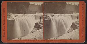
Portage is a small town located in the southwest corner of Livingston County, New York, in the United States. It sits at the southern end of Letchworth State Park. The town's name comes from the word "portage," which means carrying boats or canoes over land to get around waterfalls.
In 2010, the population of Portage was 884 people.
Contents
History of Portage
The area where Portage is located was originally home to the Haudenosaunee people. European American settlers began to arrive in the early 1800s. The town of Portage was officially formed in 1827. It was created from a part of the nearby town of Nunda.
Famous Bridges of Portage
In the mid-1800s, the Erie Railroad Company built a large wooden trestle bridge over the Genesee River. This bridge was built just above the Upper Falls. Construction started on July 1, 1851, and the bridge opened on August 14, 1852. At that time, it was known as the longest and tallest wooden bridge in the entire world.
Sadly, in the early morning of May 6, 1875, a huge fire destroyed this amazing wooden bridge.
Right after the fire, the Erie Railroad Company quickly decided to build a new bridge. This time, they used strong iron and steel. Construction for the new bridge began on June 8, 1875. It was finished very quickly, opening for trains on July 31, 1875. This iron and steel bridge was used for many years, until December 10, 2017. Today, the Genesee Arch Bridge is the third bridge to stand at this important location.
Geography of Portage
Portage covers a total area of about 69 square kilometers (26.6 square miles). Most of this area, about 68.4 square kilometers (26.4 square miles), is land. The rest, about 0.6 square kilometers (0.24 square miles), is water.
The western edge of the town is marked by the Genesee River and its deep gorge. This western border is also the line between Portage and Wyoming County. To the south, Portage borders Allegany County.
Roads and Nearby Towns
New York State Route 436 is a main road that goes from east to west across the town. It meets New York State Route 70 west of a small community called Oakland.
Portage is surrounded by several other towns. To the east, it borders the town of Nunda. To the north, it borders Mount Morris. South of Portage are the towns of Hume, Granger, and Grove, all in Allegany County. To the west, across the Genesee River, is the town of Genesee Falls in Wyoming County.
Population of Portage
| Historical population | |||
|---|---|---|---|
| Census | Pop. | %± | |
| 1850 | 2,478 | — | |
| 1860 | 1,519 | −38.7% | |
| 1870 | 1,338 | −11.9% | |
| 1880 | 1,295 | −3.2% | |
| 1890 | 1,130 | −12.7% | |
| 1900 | 1,029 | −8.9% | |
| 1910 | 1,273 | 23.7% | |
| 1920 | 860 | −32.4% | |
| 1930 | 793 | −7.8% | |
| 1940 | 945 | 19.2% | |
| 1950 | 737 | −22.0% | |
| 1960 | 733 | −0.5% | |
| 1970 | 731 | −0.3% | |
| 1980 | 771 | 5.5% | |
| 1990 | 893 | 15.8% | |
| 2000 | 859 | −3.8% | |
| 2010 | 884 | 2.9% | |
| 2016 (est.) | 855 | −3.3% | |
| U.S. Decennial Census | |||
According to the census from the year 2000, there were 859 people living in Portage. These people lived in 308 households, and 232 of these were families. The population density was about 32.6 people per square mile.
About 40.3% of the households had children under 18 living with them. Most households, 56.2%, were married couples living together. The average household had about 2.79 people.
The population was spread out by age. About 30.7% of the people were under 18 years old. About 10.8% were 65 years or older. The average age in the town was 35 years.
Communities and Places in Portage
- Dalton – This is a small community, also called a hamlet. It is located on the eastern border of the town.
- Deowesta – This was once a Native American town. It was located near the Genesee River's portage area. It was an important spot along old trade routes.
- Hunt – Another hamlet, located west of Hunt Hollow on Main Street. The G.A.R. Memorial Hall in Hunt is a historic building. It was added to the National Register of Historic Places in 2006.
- Hunt Hollow – A hamlet found on NY-70 in the middle of the town.
- Keshequa Creek – This is a stream that flows through the town of Portage.
- Oakland – A hamlet in the northern part of the town. It is located on Route 436. A historic place called Edgerley is in Oakland. It was added to the National Register of Historic Places in 1980.
- Portage – This is a hamlet on the western border of the town. It is south of the Upper, Middle, and Lower Falls on the Genesee River. This hamlet was once known as "Portage Station." It is across the river from Portageville, which is in Wyoming County.
See also
 In Spanish: Portage (Nueva York) para niños
 | John T. Biggers |
 | Thomas Blackshear |
 | Mark Bradford |
 | Beverly Buchanan |


