
Genesee River facts for kids
Quick facts for kids Genesee River |
|
|---|---|

Genesee River near Belmont
|
|

Map of Genesee River
|
|
| Native name | Čunehstí•yu• |
| Country | United States |
| State | New York, Pennsylvania |
| Counties & Tributaries |
(see Navbox, below) |
| City | Rochester, NY |
| Physical characteristics | |
| Main source | Ulysses Township, Potter County, Pennsylvania 2,275 ft (693 m) 41°53′33″N 77°43′54″W / 41.89250°N 77.73167°W |
| River mouth | Lake Ontario Charlotte, Rochester, Monroe County, New York 243 ft (74 m) 43°15′30″N 77°36′08″W / 43.25833°N 77.60222°W |
| Length | 157 mi (253 km) |
| Discharge (location 2) |
|
| Basin features | |
| Basin size | 2,500 sq mi (6,500 km2) |
The Genesee River is a river in the United States. It flows north through Pennsylvania and New York State. The river ends by flowing into Lake Ontario.
This river was very important in the 1800s. It powered many mills in the Rochester area. Today, it still helps create electricity for downtown Rochester.
Contents
River's Geology: How the Genesee River Formed
The Genesee River flows over very old rocks. As it moves north, it crosses different layers of bedrock. These layers are tilted, showing older rocks as the river goes on.
Rock Layers and Formations
The river starts in Pennsylvania, showing rocks like conglomerates, sandstones, and shales. These rocks are from the Mississippian and Pennsylvanian periods.
Further downstream, the river carves deep gorges. This area is known as The Grand Canyon of the East. Here, in Letchworth State Park, the river drops over 600 feet. It reveals even older rocks, like shales, siltstones, and some limestones from the Devonian period.
In Rochester, the river cuts through the Niagara Escarpment. This exposes limestones and shales from the Silurian age. Because the river shows so many old rock layers, it's a great place to find fossils. Scientists study these fossils to learn about Earth's history.
History of the Genesee River
The Genesee River and its surroundings have changed a lot over time. This was mainly due to huge sheets of ice called glaciers.
Ice Ages and River Changes
Over the last million years, four ice ages covered the Rochester area. The last glacier melted about 10,000 years ago. It pressed down on the land by about 2,500 feet.
Around 12,000 years ago, the melting ice caused big changes. The Genesee River's path was completely rerouted. Before the ice age, part of the river flowed south. But huge piles of glacial debris blocked its old path. This forced the river to find a new way to flow.
The lower part of the river also changed. As the land bounced back from the weight of the ice, Lake Ontario's water spilled over New York. This flooded the Genesee River's original exit, creating Irondequoit Bay. Later, as the water levels dropped, glacial debris pushed the river to its current path to the west.
Early People and Settlements
The Seneca Nation traditionally lived near the Genesee River. Their land was between the river and Canandaigua Lake. In 1766, a British officer named Thomas Davies explored the area. The High Falls was also called the Great Seneca Falls back then.
The Genesee River was vital for early settlements. Its hydropower helped flour mills and other factories grow in Rochester. The Erie Canal, built in 1825, helped these mills ship their products to New York City. The canal even crossed the Genesee River on a large stone bridge called an aqueduct. This first aqueduct was replaced in 1842.
River as a Border and Land Sales
Historically, the river's deep gorge was a clear border. It separated the lands of the Five Nations of the Iroquois to the east from the Erie people to the west.
After the American Revolution, much of upstate New York was opened for settlement. In 1779, American forces moved many Native American groups out of the area. This made it easier for new settlers to arrive. Most of New York west of the Genesee River became part of the Holland Purchase. From 1801 to 1846, this land was sold to individual owners. The Genesee River still marks the difference between "Genesee Country" to the west and the Finger Lakes region to the east.
Famous Jumps and Canals
On Friday, November 13, 1829, a famous daredevil named Sam Patch jumped to his death. He jumped from the Upper Falls in Rochester in front of 8,000 people.
In 1836, work began on the Genesee Valley Canal. This new canal was planned to connect the Erie Canal near Rochester to the Allegheny River at Olean. The canal was important for trade, but it often suffered from flood damage. The hardest part to build was around the gorges and waterfalls at Letchworth Park. The canal followed an old Native American portage route. This required many locks, which you can still see near Nunda.
The canal project was stopped in 1880. Its path was then used for the Genesee Valley Canal Railroad. Today, much of the old canal and railroad path is a public trail called the Genesee Valley Greenway. This trail started in 1991.
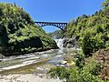
In 1852, a large wooden railroad bridge was built over the Upper Falls at Portageville. It was one of the biggest wooden bridges of its time. It took wood from 300 acres of trees to build it. In the summer of 1943, a writer named Arch Merrill walked the entire length of the Genesee River.
River Crossings
Floods and Flood Control
The Genesee River has experienced several major floods. A big thaw in March 1865 caused the worst flood in Rochester's history. Another flood in 1913 led to digging out the river's rock bed in downtown Rochester.
In 1972, Hurricane Agnes caused a record-breaking flood. The area around Wellsville was hit hardest. The amount of water from Hurricane Agnes was so great that it filled the reservoir behind the Mount Morris Dam. This dam is the largest flood control dam east of the Mississippi River. Water had to be released from the dam to prevent it from overflowing.
-
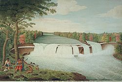
A View of the Casconchiagon or Great Seneca Falls, Lake Ontario, taken 1766 by Thomas Davies
-
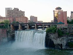
The High Falls in downtown Rochester
-
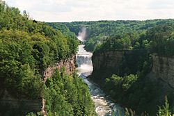
The Middle Falls in Letchworth State Park
-
Genesee River in the Town of Caneadea


Images for kids
-
Below Upper Falls in Letchworth State Park

