Monroe County, New York facts for kids
Quick facts for kids
Monroe County
|
|||
|---|---|---|---|
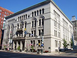
Monroe County Gordon A. Howe Office Building on Main and Fitzhugh street in Rochester.
|
|||
|
|||
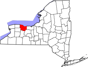
Location within the U.S. state of New York
|
|||
 New York's location within the U.S. |
|||
| Country | |||
| State | |||
| Founded | February 23, 1821 | ||
| Named for | James Monroe | ||
| Seat | Rochester | ||
| Largest city | Rochester | ||
| Area | |||
| • Total | 1,367 sq mi (3,540 km2) | ||
| • Land | 657 sq mi (1,700 km2) | ||
| • Water | 710 sq mi (1,800 km2) 52% | ||
| Population
(2020)
|
|||
| • Total | 759,443 | ||
| • Estimate
(2022)
|
752,035 |
||
| • Density | 555.55/sq mi (214.50/km2) | ||
| Time zone | UTC−5 (Eastern) | ||
| • Summer (DST) | UTC−4 (EDT) | ||
| Congressional district | 25th | ||
Monroe County is a county in the state of New York, USA. It's located along the southern shore of Lake Ontario. In 2022, about 752,035 people lived here.
The biggest city and the main government center (called the county seat) is Rochester. The county is named after James Monroe, who was the fifth president of the United States. Monroe County is also part of the larger Rochester metropolitan area and the beautiful Finger Lakes region of New York.
Contents
History of Monroe County
When counties were first created in New York in 1683, the area that is now Monroe County was part of a huge place called Albany County. This county was so big it even included parts of what is now Vermont and stretched far to the west!
Over many years, this large county was divided into smaller ones. In 1772, Albany County was split, and a new county called Tryon County was formed. This new county covered a vast western area. It was named after William Tryon, who was the governor of New York at the time.
After the American Revolutionary War, the name of Tryon County was changed in 1784. It became Montgomery County to honor General Richard Montgomery, a hero who fought in the war.
Later, in 1789, Ontario County was created from Montgomery County. This new Ontario County was also very large. It included many of the counties we know today, like Allegany, Erie, and Niagara.
Then, in 1802, Genesee County was formed by splitting off from Ontario County. Genesee County was also much larger than it is today.
Finally, in 1821, Monroe County was officially created. It was formed using parts of both Genesee and Ontario counties. This is how Monroe County got its start!
Geography of Monroe County
Monroe County covers about 1,367 square miles. A little over half of this area (710 square miles) is water, mostly from Lake Ontario. The rest (657 square miles) is land.
The county is located in the western part of New York State. It's northeast of Buffalo and northwest of Syracuse. The northern edge of Monroe County is the border with Lake Ontario, which also marks the border of the United States. Monroe County is just north of the famous Finger Lakes region.
Neighboring Counties
Monroe County shares its borders with these other counties:
- Wayne County - to the east
- Ontario County - to the southeast
- Livingston County - to the south
- Orleans County - to the west
- Genesee County - to the southwest
Main Roads
Many important roads and highways run through Monroe County, helping people travel easily.
 Invalid type: I-Toll / New York Thruway
 I-390
I-390 I-490
I-490 I-590
I-590 New York State Route 15
 New York State Route 15A
 New York State Route 18
 New York State Route 19
 New York State Route 31
 New York State Route 31F
 New York State Route 33
 New York State Route 33A
 New York State Route 36
 New York State Route 64
 New York State Route 65
 New York State Route 96
 New York State Route 104
 New York State Route 153
 New York State Route 250
 New York State Route 251
 New York State Route 252
 New York State Route 259
 New York State Route 286
 New York State Route 390
 New York State Route 404
 New York State Route 441
 New York State Route 531
 New York State Route 590
 Lake Ontario State Parkway
Economy of Monroe County
Monroe County is home to many important businesses, including some that are known worldwide. Companies like Eastman Kodak, Paychex, and Pictometry International have their main offices here. Even though Xerox isn't headquartered in Rochester anymore, it still has major offices and factories in Monroe County.
Other well-known businesses, like the grocery store chain Wegmans and the fashion brand Hickey Freeman, also started and grew here.
High Technology
Monroe County is becoming a hub for high technology. This means many new, smaller companies are starting up, especially in areas like imaging and optical science. Rochester is even called the "world capital of imaging" because of all the work done here in that field.
Big universities like the University of Rochester and Rochester Institute of Technology (RIT) help these new tech companies grow. They have special programs for imaging and optics, which are about how light works and how we see things.
Major Employers
Many people in Monroe County work in healthcare. The University of Rochester (which includes many hospitals) is the largest employer, with over 27,000 workers. Rochester Regional Health is the second largest, and Wegmans is the third.
People of Monroe County (Demographics)
| Historical population | |||
|---|---|---|---|
| Census | Pop. | %± | |
| 1830 | 49,855 | — | |
| 1840 | 64,902 | 30.2% | |
| 1850 | 87,650 | 35.0% | |
| 1860 | 100,648 | 14.8% | |
| 1870 | 117,868 | 17.1% | |
| 1880 | 144,903 | 22.9% | |
| 1890 | 189,586 | 30.8% | |
| 1900 | 217,854 | 14.9% | |
| 1910 | 283,212 | 30.0% | |
| 1920 | 352,034 | 24.3% | |
| 1930 | 423,881 | 20.4% | |
| 1940 | 438,230 | 3.4% | |
| 1950 | 487,632 | 11.3% | |
| 1960 | 586,387 | 20.3% | |
| 1970 | 711,917 | 21.4% | |
| 1980 | 702,238 | −1.4% | |
| 1990 | 713,968 | 1.7% | |
| 2000 | 735,343 | 3.0% | |
| 2010 | 744,344 | 1.2% | |
| 2020 | 759,443 | 2.0% | |
| 2022 (est.) | 752,035 | 1.0% | |
| U.S. Decennial Census 1790-1960 1900-1990 1990-2000 2010-2020 |
|||
In 2020, there were 759,443 people living in Monroe County. Most people (68.6%) were White, 15.7% were African American, and 4.3% were Asian. About 9.6% of the population was Hispanic or Latino.
The average age of people in the county was 39 years old. About 21% of the population was 18 years old or younger. More than half (52%) of the population was Female, and 48% was Male.
The average income for a household in the county was $62,103. About 12.7% of the people lived below the poverty line. Most adults (90.4%) had at least a High school diploma, and 38.6% had a Bachelor's degree or higher.
Many different religions are practiced in Monroe County. In 2020, about half of the county's population (50.2%) followed a Religion. The largest group was Catholic (27.5%), followed by Protestant (9.4%), and Nondenominational Christians (6.0%). There are also many Muslim, Hindu, and Jewish people living here.
2020 Census Information
| Race | Num. | Perc. |
|---|---|---|
| White (NH) | 506,153 | 66.6% |
| Black or African American (NH) | 112,710 | 14.84% |
| Native American (NH) | 1,320 | 0.17% |
| Asian (NH) | 32,294 | 4.25% |
| Pacific Islander (NH) | 181 | 0.02% |
| Other/mixed (NH) | 34,040 | 4.48% |
| Hispanic or Latino | 72,745 | 9.58% |
Education in Monroe County
Schools for Kids
Most children in Monroe County go to public schools. There are also many private schools, including those run by the Roman Catholic Diocese of Rochester.
Public Schools
Monroe County has about 25 public school districts. The largest is the Rochester City School District. Other districts serve the towns and villages around Rochester.
| Name | BOCES | Established | District population | Professional staff | Support staff | Median teacher salary | Enrollment | Budget | Per pupil cost |
|---|---|---|---|---|---|---|---|---|---|
| Avon Central School District | ? | ? | ? | ? | ? | ? | ? | ? | ? |
| Brighton Central School District | Monroe #1 | 1966 | 26450 | 372 | 293 | $63580 | 3681 | $74.0 million | $18444 |
| Brockport Central School District | Monroe #2–Orleans | 1927 | 30000 | 356 | 362 | $59971 | 3411 | $78.9 million | $23128 |
| Byron-Bergen Central School District | ? | ? | ? | ? | ? | ? | ? | ? | ? |
| Caledonia-Mumford Central School District | ? | ? | ? | ? | ? | ? | ? | ? | ? |
| Churchville-Chili Central School District | Monroe #2–Orleans | 1950 | 30000 | 350 | 322 | $59752 | 3845 | $82.6 million | $21523 |
| East Irondequoit Central School District | Monroe #1 | 1956 | 27000 | 335 | 352 | $56447 | 3145 | $76.3 million | $24257 |
| East Rochester Union Free School District | Monroe #1 | 1920 | 8200 | 125 | 91 | $53829 | 1179 | $27.4 million | $23282 |
| Fairport Central School District | Monroe #1 | 1951 | 40000 | 645 | 516 | $65630 | 5905 | $123.3 million | $20874 |
| Gates Chili Central School District | Monroe #2–Orleans | 1956 | 35000 | 451 | 402 | $61423 | 4123 | $100.8 million | $24459 |
| Greece Central School District | Monroe #2–Orleans | 1928 | 96000 | 1127 | 1249 | $72100 | 11094 | $221.2 million | $19941 |
| Hilton Central School District | Monroe #2–Orleans | 1949 | 25323 | 421 | 367 | $60407 | 4452 | $80.0 million | $17965 |
| Holley Central School District | Monroe #2–Orleans | 1949 | 7774 | 125 | 87 | $53366 | 1051 | $24.4 million | $23216 |
| Honeoye Falls-Lima Central School District | Monroe #1 | 1969 | 10500 | 219 | 205 | $62074 | 2212 | $48.5 million | $19542 |
| Kendall Central School District | Monroe #2–Orleans | 1957 | 3000 | 86 | 76 | $53551 | 704 | $17.4 million | $22269 |
| Penfield Central School District | Monroe #1 | 1948 | 31000 | 438 | 477 | $61612 | 4564 | $93.3 million | $20445 |
| Pittsford Central School District | Monroe #1 | 1946 | 33000 | 575 | 656 | $67848 | 5685 | $125.5 million | $22280 |
| Rochester City School District | None | 1841 | 209000 | 5786 (total) | 5786 (total) | $61617 | 30217 | $864.7 million | $21546 |
| Rush-Henrietta Central School District | Monroe #1 | 1947 | 46000 | 613 | 603 | $63344 | 5247 | $119.9 million | $22838 |
| Spencerport Central School District | Monroe #2–Orleans | 1949 | 23000 | 408 | 351 | $62348 | 3584 | $77.1 million | $21521 |
| Victor Central School District | ? | ? | ? | ? | ? | ? | ? | ? | ? |
| Webster Central School District | Monroe #1 | 1948 | 54093 | 801 | 631 | $66408 | 8549 | $163.9 million | $19167 |
| West Irondequoit Central School District | Monroe #1 | 1953 | 23754 | 344 | 258 | $59855 | 3568 | $71.2 million | $19916 |
| Wheatland–Chili Central School District | Monroe #2–Orleans | 1955 | 5100 | 80 | 63 | $54967 | 691 | $17.8 million | $23837 |
Private Schools
There are a few private schools in Monroe County that serve many students:
- Allendale Columbia School in Pittsford, which helps students get ready for college.
- The Harley School in Brighton, also a college prep school.
- Mary Cariola Children's Center, which helps children with special needs.
- The Rochester School for the Deaf, a historic school for deaf students.
Religious Schools
Monroe County also has schools connected to different religions:
- A few small Jewish and Islamic schools.
- About ten primary schools run by the Roman Catholic Diocese of Rochester.
- Four Catholic high schools:
| School | Founding religious order | Location | Established | Grades |
|---|---|---|---|---|
| Aquinas Institute | Basilian | City of Rochester | 1902 | 6–12 |
| Bishop Kearney High School | Christian Brothers, Sisters of Notre Dame | Irondequoit | 1962 | 6–12 |
| McQuaid Jesuit High School | Jesuits | Brighton | 1954 | 6–12 |
| Our Lady of Mercy School for Young Women | Sisters of Mercy | Brighton | 1928 | 6–12 |
- More than two dozen schools run by different Christian groups. Two of these are larger:
| School | Religious affiliation | Location | Established | Grades |
|---|---|---|---|---|
| The Charles Finney School | Non-denominational Christian | Penfield | 1992 | K–12 |
| Northstar Christian Academy | Baptist | Gates | 1972 | K–12 |
Colleges and Universities
Monroe County is home to many colleges and universities where students can continue their education after high school:
- Bryant & Stratton College
- Colgate Rochester Crozer Divinity School
- Monroe Community College
- Nazareth University
- Roberts Wesleyan College
- Rochester Institute of Technology
- St. Bernard's School of Theology and Ministry
- St. John Fisher University
- SUNY Brockport
- University of Rochester
Some other colleges also have offices or smaller campuses here, like Cornell University and Ithaca College.
Parks and Fun Places
County Parks
Monroe County has many beautiful parks that are great for outdoor activities.
- Abraham Lincoln Park
- Black Creek Park
- Churchville Park
- Devil's Cove Park
- Durand Eastman Park
- Ellison Park
- Genesee Valley Park
- Greece Canal Park
- Highland Park
- Irondequoit Bay Park West
- Lehigh Valley Trail Park
- Lucian Morin Park
- Mendon Ponds Park
- Northampton Park
- Oatka Creek Park
- Ontario Beach Park
- Powder Mills Park
- Seneca Park
- Seneca Park Zoo
- Tryon Park
- Webster Park
State Parks
New York State also has parks in Monroe County:
- Hamlin Beach State Park
- Irondequoit Bay State Marine Park
Golf Courses
If you like golf, Monroe County has many courses to play on:
- Arrowhead Golf Course & Marina
- Deerfield Golf & Country Club
- Durand Eastman Golf Course
- Genesee Valley Golf Course
- Majestic Hills Golf Course
- Mill Creek Golf Club
- Morgan's Crossing
- Monroe Golf Club
- Shadow Lake Golf & Racquet Club
- Timber Ridge Golf Club
- White Birch Golf Course
Communities in Monroe County
Bigger Towns and Cities
Here are some of the largest places where people live in Monroe County:
| # | Location | Population | Type | Area |
|---|---|---|---|---|
| 1 | Rochester | 211,328 | City | Inner Rochester |
| 2 | Irondequoit | 51,692 | Town/CDP | Inner Rochester |
| 3 | Brighton | 37,137 | Town | Inner Rochester |
| 4 | Greece | 96,926 | Town | Inner Rochester |
| 5 | North Gates | 9,512 | CDP | Inner Rochester |
| 6 | Brockport | 8,366 | Village | West |
| 7 | East Rochester | 6,587 | Town/village | Inner Rochester |
| 8 | Hilton | 5,886 | Village | West |
| 9 | Hamlin | 5,521 | CDP | West |
| 10 | Webster | 5,399 | Village | Inner Rochester |
| 11 | Fairport | 5,353 | Village | Inner Rochester |
| 12 | Gates | 4,910 | CDP | Inner Rochester |
| 13 | Clarkson | 4,358 | CDP | West |
| 14 | Spencerport | 3,601 | Village | West |
| 15 | Honeoye Falls | 2,674 | Village | Southeast |
| 16 | Scottsville | 2,001 | Village | Southwest |
| 17 | Churchville | 1,961 | Village | Southwest |
| 18 | Pittsford | 1,355 | Village | Inner Rochester |
| 19 | Gates | 29,167 | Town | Inner Rochester |
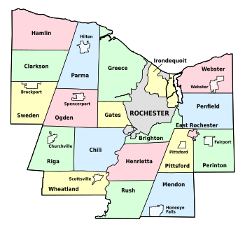
Towns in Monroe County
Hamlets in Monroe County
A hamlet is a small community or area within a town that doesn't have its own separate government. The town it belongs to is listed in parentheses.
- Genesee Junction (Chili)
- Egypt (Perinton)
- Adams Basin (Ogden)
- Bushnell's Basin (Perinton)
- Gates Center (Gates)
- Garbutt (Scottsville)
- Mumford (Wheatland)
- Union Hill (Webster)
- Mendon Center (Mendon)
- Seabreeze (Irondequoit)
- Summerville (Irondequoit)
- Parma Center (Parma)
- Riga Center (Riga)
- Sweden Center (Sweden)
- West Webster (Webster)
- North Chili (Chili)
- Clarkson Corners (Clarkson)
- Clifton (Chili)
- Industry (Rush)
- Belcoda (Wheatland)
- Coldwater (Gates)
- Barnard (Greece)
- Beattie Beach (Greece)
- Braddock Bay (Greece)
- Braddock Heights (Greece)
- Elmgrove (Greece)
- Grandview Heights (Greece)
- Grand View Beach (Greece)
- North Greece (Greece)
- Ridgemont (Greece)
- West Greece (Greece)
See also
 In Spanish: Condado de Monroe (Nueva York) para niños
 | Janet Taylor Pickett |
 | Synthia Saint James |
 | Howardena Pindell |
 | Faith Ringgold |


