Genesee County, New York facts for kids
Quick facts for kids
Genesee County
|
|||
|---|---|---|---|

|
|||
|
|||

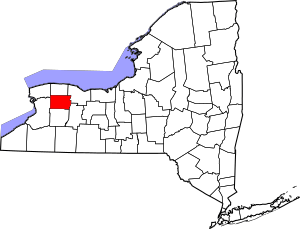
Location within the U.S. state of New York
|
|||
 New York's location within the U.S. |
|||
| Country | |||
| State | |||
| Founded | March 1803 | ||
| Seat | Batavia | ||
| Largest city | Batavia | ||
| Area | |||
| • Total | 495 sq mi (1,280 km2) | ||
| • Land | 493 sq mi (1,280 km2) | ||
| • Water | 2.4 sq mi (6 km2) 0.5% | ||
| Population
(2020)
|
|||
| • Total | 58,388 | ||
| • Density | 118.4/sq mi (45.7/km2) | ||
| Time zone | UTC−5 (Eastern) | ||
| • Summer (DST) | UTC−4 (EDT) | ||
| Congressional district | 24th | ||
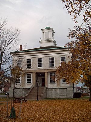
Genesee County is a place in New York, a state in the United States. In 2020, about 58,388 people lived there. Its main town, called the county seat, is Batavia. The name Genesee comes from the Seneca language, meaning "the Beautiful Valley." The county was officially created in 1802 and fully set up in 1803. Genesee County is part of the Finger Lakes region of New York.
The county is also part of the larger Rochester area. It is located in Western New York. Another place, Genesee County, Michigan, was named after Genesee County in New York.
Contents
History of Genesee County
Early Times and Ice Age Discoveries
The Hiscock Site in Byron, New York shows that people lived in this area a very long time ago. Scientists have found tools, pottery, and bones there that are 10,000 to 12,000 years old. This was during the Ice Age. They even found parts of a mastodon, which is like an ancient elephant! This site is very important for understanding early human life in North America.
Different Indigenous peoples lived here for thousands of years. Before Europeans arrived, the Iroquoian-speaking Seneca Nation lived in central New York. They were one of the first Five Nations of the Haudenosaunee (Iroquois Confederacy). In the 1600s, the Seneca expanded their territory, moving out other tribes like the Wenro, Erie, and Neutrals.
Colonial Era and New York State
When New York State first created counties in 1683, Genesee County was part of a huge area called Albany County. This county was so big it included parts of present-day Vermont and even stretched west to the Pacific Ocean! Over time, this large county was divided into smaller ones.
In 1772, Albany County was split, and the western part became Tryon County. Later, in 1784, Tryon County was renamed Montgomery County. Other states, like Pennsylvania and Massachusetts, also claimed this land, but New York eventually took control. In 1789, Ontario County was formed from Montgomery County.
It wasn't until 1793, with the Holland Purchase, that Western New York truly became part of New York State. Land in this region was sold through the Holland Land Company's office in Batavia, starting in 1801. At first, all of Western New York was part of the newly created Genesee County.
Genesee County was officially created from Ontario County. It was fully set up and separated in March 1803. Over the years, Genesee County became smaller as new counties were created from its land. For example, Allegany County was formed in 1806. Later, Cattaraugus, Chautauqua, and Niagara Counties were created in 1808. In 1821, Livingston and Monroe Counties were formed. Then, Orleans County was created in 1825. Finally, in 1841, Wyoming County was formed, leaving Genesee County with its current size of about 500 square miles.
19th Century Politics: The Anti-Masonic Movement
In the 1800s, Genesee County was part of a region called the "burned-over district." This area saw many religious awakenings. This strong religious feeling helped a movement against a group called Freemasonry grow. This movement later became the first "third party" in American politics.
By the 1820s, many leaders in Genesee County were Freemasons. In 1826, a man named William Morgan from Batavia disappeared. He had planned to publish a book about the secret rituals of Freemasonry. His disappearance led to a big campaign against Freemasonry. Many people believed he was harmed because of his plans.
The investigation into Morgan's disappearance faced problems because many officials were Freemasons. This made people even more suspicious. Large meetings were held across the county to discuss the issue. The goal of the anti-Masonic movement was to remove Freemasons from political jobs. Leaders like Thurlow Weed and William H. Seward helped turn this movement into a strong political party.
The Anti-Masonic Party was very popular in Genesee County from 1827 to 1833. They often won most of the votes and every county office. People saw this party as a way to bring fairness back to politics. Many churches, especially Baptist and Presbyterian, supported the Anti-Masons. The party was strongest in larger towns like Batavia and Le Roy. This movement helped more people get involved in politics in New York.
Modern Day Genesee County
In 2009, the City and Town of Batavia started looking into ways to combine or share government services to work more efficiently.
Geography of Genesee County
Genesee County covers about 495 square miles. Most of this is land (493 square miles), with a small amount of water (2.4 square miles). The county is located east of Buffalo and southwest of Rochester in western New York State.
Neighboring Counties
Genesee County shares borders with these other counties:
- Erie County - to the west
- Livingston County - to the southeast
- Monroe County - to the northeast
- Niagara County - to the northwest
- Orleans County - to the north
- Wyoming County - to the south
Main Roads
Many important roads pass through Genesee County:
Waterways and Natural Areas
Genesee County has several important waterways, including:
- Black Creek
- Canaseraga Creek
- Honeoye Creeks
- Mud Creek
- Murder Creek
- Oak Orchard Creek
- Oatka Creek
- Ransom Creek
- Tonawanda Creek
The county is also home to parts of the Iroquois National Wildlife Refuge, which is a protected area for wildlife. Other state protected areas include Darien Lakes State Park, Oak Orchard Wildlife Management Area, and Tonawanda Wildlife Management Area.
Genesee County also has its own parks. Genesee County Park and Forest has 430 acres of woods and hills. DeWitt Recreation Area is a 63-acre park with a 38-acre pond.
Population Changes Over Time
| Historical population | |||
|---|---|---|---|
| Census | Pop. | %± | |
| 1810 | 12,588 | — | |
| 1820 | 58,093 | 361.5% | |
| 1830 | 52,147 | −10.2% | |
| 1840 | 59,587 | 14.3% | |
| 1850 | 28,488 | −52.2% | |
| 1860 | 32,189 | 13.0% | |
| 1870 | 31,606 | −1.8% | |
| 1880 | 32,806 | 3.8% | |
| 1890 | 33,265 | 1.4% | |
| 1900 | 34,561 | 3.9% | |
| 1910 | 37,615 | 8.8% | |
| 1920 | 37,976 | 1.0% | |
| 1930 | 44,468 | 17.1% | |
| 1940 | 44,481 | 0.0% | |
| 1950 | 47,584 | 7.0% | |
| 1960 | 53,994 | 13.5% | |
| 1970 | 58,722 | 8.8% | |
| 1980 | 59,400 | 1.2% | |
| 1990 | 60,060 | 1.1% | |
| 2000 | 60,370 | 0.5% | |
| 2010 | 60,079 | −0.5% | |
| 2020 | 58,388 | −2.8% | |
| U.S. Decennial Census 1790-1960 1900-1990 1990-2000 2010-2020 |
|||
The population of Genesee County has changed a lot over the years. In 1810, about 12,588 people lived there. By 2020, the population had grown to 58,388.
Who Lives in Genesee County?
According to the 2020 Census, most people in Genesee County are White (about 87.3%). Other groups include Black or African American (2.32%), Native American (0.62%), and Asian (0.71%). About 4.71% of the population is Hispanic or Latino.
Education in Genesee County
Genesee County has several public school districts where students attend classes:
- Akron Central School District
- Alden Central School District
- Alexander Central School District
- Attica Central School District
- Batavia City School District
- Byron-Bergen Central School District
- Elba Central School District
- Le Roy Central School District
- Oakfield-Alabama Central School District
- Pavilion Central School District
- Pembroke Central School District
There is also one state-run school, the New York State School for the Blind.
Several private schools are also in the county, including:
- St. Joseph's School, Batavia
- Notre Dame High School, Batavia
- St. Paul Lutheran School, Batavia
For higher education, Genesee Community College has its main campus in the Town of Batavia.
Communities in Genesee County
Genesee County has several towns and villages. The largest settlement is Batavia, which is also the county seat.
Larger Towns and Villages
| # | Location | Population | Type | Sector |
|---|---|---|---|---|
| 1 | †Batavia | 15,600 | City | Northwest |
| 2 | Le Roy | 4,391 | Village | Southeast |
| 3 | ‡Attica | 2,547 | Village | Southwest |
| 4 | Oakfield | 1,813 | Village | Northwest |
| 5 | Bergen | 1,176 | Village | Northeast |
| 6 | Corfu | 709 | Village | Southwest |
| 7 | Elba | 676 | Village | Northeast |
| 8 | Pavilion | 646 | CDP | Southeast |
| 9 | Alexander | 509 | Village | Southwest |
† - County Seat
‡ - Not Wholly in this County
Towns in Genesee County
Other Small Communities
Native American Lands
See also
 In Spanish: Condado de Genesee (Nueva York) para niños
 | Roy Wilkins |
 | John Lewis |
 | Linda Carol Brown |


