
Oak Orchard Creek facts for kids
Quick facts for kids Oak Orchard Creek |
|
|---|---|

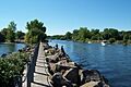
The mouth of the creek, at Point Breeze
|
|


Location of the mouth of the Oak Orchard Creek in New York State.
|
|
| Country | United States |
| State | New York |
| Counties | Orleans, Genesee |
| Physical characteristics | |
| Main source | Elba, Genesee County 43°02′40″N 78°12′44″W / 43.04444°N 78.21222°W |
| River mouth | Lake Ontario Carlton, Orleans County 43°22′18″N 78°11′32″W / 43.37167°N 78.19222°W |
Oak Orchard Creek is a stream that flows into Lake Ontario in Orleans County, New York, in the United States.
This creek is special because it flows through a large wetland area called Oak Orchard Creek Marsh. About 600 acres (2.4 square kilometers) of this marsh were named a National Natural Landmark in 1973. These marshlands are very important for migratory birds, which are birds that travel long distances each year. The area is protected by both state and federal conservation areas, helping to keep it safe for wildlife.
Contents
Where Does the Creek Flow?
.jpg)
Oak Orchard Creek begins south of the Oak Orchard Creek Marsh, also known as the "Alabama Swamp." This starting point is right on the border between Orleans and Genesee counties. The swamp itself is home to two important wildlife areas: the Oak Orchard Wildlife Management Area (a state reserve) and the Iroquois National Wildlife Refuge (a national reserve). Both of these places are well-known as major resting spots for birds that are migrating.
The swamp formed because the river was partly blocked by rocks and dirt left behind by glaciers. There's also a natural rock formation made of limestone and dolomite called the Lockport Formation. This formation is part of the Niagara Escarpment, which is a long cliff-like ridge.

After leaving the swamp, the creek flows north. It goes over the escarpment, creating a series of waterfalls and rapids near Shelby Center. Then, it passes through the Village of Medina and into a small body of water called Glenwood Lake, just north of the village.
The creek then leaves the town of Ridgeway and cuts through a small part of the town of Gaines. As it enters the town of Carlton, the creek gets much wider. This wide part is now known as Waterport Pond, or sometimes Lake Alice. The small town of Waterport is located on the south side of this pond. A dam at the northeast end of the pond helps control the water flow.
Oak Orchard Creek becomes narrower again as it flows under Route 18 and the Lake Ontario State Parkway. Finally, it empties into Lake Ontario at a place called Point Breeze. The Oak Orchard State Marine Park is also located here. Even in winter, the lower part of the creek usually doesn't freeze. This is probably because water flows steadily from the hydro-plant at Waterport.
Fun Activities at Oak Orchard Creek
Oak Orchard Creek is a great place for outdoor activities, especially if you love nature and fishing!
Boating Adventures
There are several places where you can launch a boat into the lower part of Oak Orchard Creek. Two of these spots are near Point Breeze, right at the state park. You can find three more boat launches close to the Route 18 overpass. Boating is mostly limited to a short distance upstream from a spot called Toms Landing because the water gets too shallow further up. Most people who use boats here come to fish.
Fishing Fun
The state fish hatcheries regularly release different types of fish into the river each year. These include brown trout, salmon, and steelhead. You can enjoy fishing from a boat in the lower parts of the creek. In the upper parts, you can wade into the water to fish. You can also fish from the shore along the entire length of the creek.
Other Outdoor Activities
The public lands around Oak Orchard Creek are perfect for birdwatching and hiking. If you visit the Oak Orchard Swamp, you might be able to do other activities like hunting and trapping, but you'll need a special permit for those. Boating in the swamp is only allowed for non-powered boats, like canoes or kayaks. Picnicking and camping are also allowed, but only in specific areas.
Images for kids
-
The mouth of the creek, at Point Breeze
-
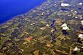
Aerial view of Oak Orchard Creek, 2013. The creek is slightly right of center in the photo, running roughly vertically from the bottom of the image to the lake at top.
-
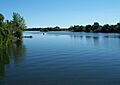
Waterport Pond, also known as Lake Alice, is the widest point of Oak Orchard Creek
