
Orleans County, New York facts for kids
Quick facts for kids
Orleans County
|
|||
|---|---|---|---|

County Courthouse in Albion
|
|||
|
|||

Location within the U.S. state of New York
|
|||
 New York's location within the U.S. |
|||
| Country | |||
| State | |||
| Founded | 1824 | ||
| Named for | House of Orléans | ||
| Seat | Albion | ||
| Largest village | Medina | ||
| Area | |||
| • Total | 817 sq mi (2,120 km2) | ||
| • Land | 391 sq mi (1,010 km2) | ||
| • Water | 426 sq mi (1,100 km2) 52% | ||
| Population
(2020)
|
|||
| • Total | 40,343 |
||
| • Density | 103/sq mi (40/km2) | ||
| Time zone | UTC−5 (Eastern) | ||
| • Summer (DST) | UTC−4 (EDT) | ||
| Congressional districts | 24th, 25th | ||


Orleans County is a county located in the western part of New York State. In 2020, about 40,343 people lived here. The main town, or county seat, is Albion.
Historians aren't completely sure how the county got its name. One idea is that it was named after the French Royal House of Orléans. Another idea is that it honored Andrew Jackson's victory in New Orleans. Orleans County is also part of the beautiful Finger Lakes region of New York. It sits right on the southern shore of Lake Ontario. Since the late 1900s, it has been considered part of the larger Rochester area.
Contents
History of Orleans County
When the British first set up counties in New York in 1683, the area that is now Orleans County was part of a huge place called Albany County. This county was enormous! It covered much of what is now New York State, all of Vermont, and even stretched west towards the Pacific Ocean (at least on paper).
Over time, Albany County became smaller. In 1772, it was split into three parts. One of these new parts was Tryon County. This county was also very large, covering much of western New York. It was named after William Tryon, who was the colonial governor of New York at the time. Many Native American groups, like the Onondaga and Oneida, lived in this western area.
During the American Revolutionary War, many people in Tryon County who supported the British (called Loyalists) moved to Canada. After the war ended in 1784, Tryon County's name was changed to Montgomery County. This was to honor General Richard Montgomery, an American hero who died during the war.
As more people moved to western New York from other parts of the state and New England, new counties were created. In 1789, Ontario County was formed from Montgomery County. Then, in 1802, Genesee County was created from Ontario County.
Finally, in 1824, Orleans County was formed by splitting off from Genesee County. There was a small debate about whether to name it after President Andrew Jackson or President John Adams.
Geography of Orleans County
Orleans County covers a total area of about 817 square miles. A big part of this area, about 426 square miles (or 52%), is water. This is because Orleans County extends north into Lake Ontario all the way to the border with Canada. The county has more water than land!
Orleans County is located in western New York State. It's northeast of Buffalo and west of Rochester.
The Erie Canal is a famous waterway that runs through the middle of the county from east to west. When it was finished in 1824, it brought many new settlers to the area. The canal helped local businesses grow by making it easier to transport goods and people.
Neighboring Counties
- Monroe County - to the east
- Genesee County - to the south
- Niagara County - to the west
Protected Natural Areas
- Iroquois National Wildlife Refuge (part of it is in Orleans County)
- Lakeside Beach State Park
- Oak Orchard State Marine Park
- Oak Orchard Wildlife Management Area
- Tonawanda Wildlife Management Area
Population Information
| Historical population | |||
|---|---|---|---|
| Census | Pop. | %± | |
| 1830 | 17,732 | — | |
| 1840 | 25,127 | 41.7% | |
| 1850 | 28,501 | 13.4% | |
| 1860 | 28,717 | 0.8% | |
| 1870 | 27,689 | −3.6% | |
| 1880 | 30,128 | 8.8% | |
| 1890 | 30,803 | 2.2% | |
| 1900 | 30,164 | −2.1% | |
| 1910 | 32,000 | 6.1% | |
| 1920 | 28,619 | −10.6% | |
| 1930 | 28,795 | 0.6% | |
| 1940 | 27,760 | −3.6% | |
| 1950 | 29,832 | 7.5% | |
| 1960 | 34,159 | 14.5% | |
| 1970 | 37,305 | 9.2% | |
| 1980 | 38,496 | 3.2% | |
| 1990 | 41,846 | 8.7% | |
| 2000 | 44,171 | 5.6% | |
| 2010 | 42,883 | −2.9% | |
| 2020 | 40,343 | −5.9% | |
| U.S. Decennial Census 1790-1960 1900-1990 1990-2000 2010-2013 |
|||
In 2010, there were 42,883 people living in Orleans County. About 16,119 households and 10,872 families called the county home. The average number of people in a household was 2.5.
The population was spread out by age. About 19.8% of the people were under 18 years old. About 17.4% were 65 years or older. The average age of people in the county was 41 years.
The median income for a household in the county was $48,731. This means that half of the households earned more than this amount, and half earned less. About 15.2% of the population lived below the poverty line.
2020 Census Data
| Race | Num. | Perc. |
|---|---|---|
| White (NH) | 34,037 | 84.4% |
| Black or African American (NH) | 1,840 | 4.6% |
| Native American (NH) | 177 | 0.5% |
| Asian (NH) | 154 | 0.4% |
| Pacific Islander (NH) | 12 | 0.02% |
| Other/Mixed (NH) | 2,036 | 5.04% |
| Hispanic or Latino | 2,087 | 5.2% |
Education in Orleans County
Orleans County has several schools and colleges.
Public Schools
The county has five main school districts. Some of these districts might also include parts of neighboring counties.
- Lyndonville Central School District
- Medina Central School District
- Albion Central School District
- Kendall Central School District
- Holley Central School District
These school districts work with larger educational service centers called BOCES.
Private School
There is one private school in the county for students from kindergarten through 12th grade:
- Orleans County Christian School
Colleges
One college has campuses in Orleans County:
- Genesee Community College - Medina Campus (The Albion campus has moved its operations to Medina).
Fun Things to Do
Orleans County has many interesting places to visit and fun activities. You can find an interactive map of notable places on the county's tourism website.
Lakes and Ponds
There are two main public boating areas created by dams on Oak Orchard Creek:
Libraries
Orleans County has four public libraries where you can find books and learn new things:
- Community Free Library in Holley
- Hoag Library in Albion
- Lee-Whedon Memorial Library in Medina
- Yates Community Library in Lyndonville
Museums
You can explore history and learn about the past at these six museums in Orleans County:
- Clarendon Historical Society Museum & Farwell's Settlement
- The Cobblestone Museum
- Holley Depot Museum
- Medina Railroad Museum
- Murray-Holley Historical Society
- Oak Orchard Lighthouse Museum
Parks
There are two State Parks and many local parks throughout the county for outdoor fun:
- Lakeside Beach State Park
- Oak Orchard Marine State Park
Getting Around
Orleans County has several small airports and one public airport called Pine Hill Airport (New York) (9G6).
RTS Orleans provides bus service in the county. The county's Department of Public Works helps maintain roads, bridges, and ditches. They also clear snow and ice. Each town and village has its own team for road maintenance.
Main Roads
 New York State Route 18
 New York State Route 31
 New York State Route 31A
 New York State Route 31E
 New York State Route 63
 New York State Route 98
 New York State Route 104
 New York State Route 237
 New York State Route 269
 New York State Route 272
 New York State Route 279
 New York State Route 387
 Lake Ontario State Parkway
- List of county routes in Orleans County, New York
Towns and Villages
Larger Settlements (Villages)
| # | Location | Population |
|---|---|---|
| 1 | Medina | 6,065 |
| 2 | †Albion | 6,056 |
| 3 | Holley | 1,811 |
| 4 | Lyndonville | 838 |
Towns
Villages
- Albion (This is the county seat)
- Holley
- Lyndonville
- Medina
Hamlets
- Ashwood
- Baldwin Corner
- Barre Center
- Brockville
- Carlton Station
- Childs
- County Line
- Eagle Harbor
- East Shelby
- Fancher
- Gaines
- Hindsburg
- Hulberton
- Jeddo
- Jones Beach
- Kendall Mills
- Kent
- Kenyonville
- Knowlesville
- Kuckville
- Lomond Shore
- Millers
- Millville
- Oak Orchard
- Point Breeze
- Sawyer
- Shadigee
- Shelby Center
- Sunset Beach
- Waterport
- West Barre
- West Gaines
- West Shelby
- Yates Center
Images for kids
-
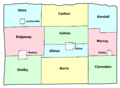
This map shows the towns and villages within Orleans County.
_-_Towns_and_Villages.svg)
See also
 In Spanish: Condado de Orleans (Nueva York) para niños
