Clarendon, New York facts for kids
Quick facts for kids
Clarendon, New York
Farwell's Mills
|
|
|---|---|

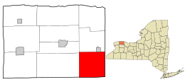
Location in Orleans County and the state of New York.
|
|

Location of New York in the United States
|
|
| Country | United States |
| State | New York |
| County | Orleans |
| Area | |
| • Total | 35.22 sq mi (91.22 km2) |
| • Land | 35.22 sq mi (91.22 km2) |
| • Water | 0.00 sq mi (0.00 km2) |
| Elevation | 610 ft (186 m) |
| Population
(2010)
|
|
| • Total | 3,648 |
| • Estimate
(2016)
|
3,529 |
| • Density | 100.20/sq mi (38.69/km2) |
| Time zone | UTC-5 (Eastern (EST)) |
| • Summer (DST) | UTC-4 (EDT) |
| ZIP code |
14429
|
| Area code(s) | 585 |
| FIPS code | 36-15880 |
| GNIS feature ID | 0978830 |
Clarendon is a town in Orleans County, New York. In 2010, about 3,648 people lived there. The town got its name from Clarendon, Vermont.
You can find the Town of Clarendon in the southeast part of Orleans County. Two main roads, New York State Route 31A and New York State Route 237, cross paths in the town.
Contents
History of Clarendon
Early Settlement and Naming
People first settled in the Clarendon area around 1811. The Town of Clarendon was officially created in 1820. This happened before Orleans County was even formed. It was separated from the town of Sweden.
The area was first known as "Farwell's Mills." This name came from one of the first settlers, who arrived in 1810. Clarendon was once famous for its stone quarries and cement factories.
Important Buildings and Landmarks
In late 2006, an old stone church was taken down. This happened because the owner and the town board disagreed. The church was built around 1830. It served the community until 1980, when its contents were sold. After that, it became an antique and book shop. This church was a well-known landmark in Clarendon for many years. The current owner of the land still has the original bell. This bell was made in Troy, New York by the Meneely Bell Company.
Around 1990, the volunteer fire department building, which was next to the church, almost completely burned down.
Two historic buildings in Clarendon are listed on the National Register of Historic Places. These are the Butterfield Cobblestone House and the Clarendon Stone Store.
Geography of Clarendon
Location and Size
According to the United States Census Bureau, the town covers a total area of about 35.2 square miles (91.2 square kilometers). All of this area is land.
The eastern border of Clarendon is shared with Monroe County. Specifically, it borders the Town of Sweden. The southern border of Clarendon touches Genesee County. It borders the Town of Byron there.
Clarendon-Linden Fault System
The Clarendon-Linden fault system is partly named after Clarendon. This fault system causes the land to rise noticeably just west of Route 237.
People of Clarendon
Population Changes Over Time
| Historical population | |||
|---|---|---|---|
| Census | Pop. | %± | |
| 1830 | 2,025 | — | |
| 1840 | 2,251 | 11.2% | |
| 1850 | 1,809 | −19.6% | |
| 1860 | 1,831 | 1.2% | |
| 1870 | 1,668 | −8.9% | |
| 1880 | 1,797 | 7.7% | |
| 1890 | 1,731 | −3.7% | |
| 1900 | 1,518 | −12.3% | |
| 1910 | 1,335 | −12.1% | |
| 1920 | 1,139 | −14.7% | |
| 1930 | 1,224 | 7.5% | |
| 1940 | 1,176 | −3.9% | |
| 1950 | 1,287 | 9.4% | |
| 1960 | 1,659 | 28.9% | |
| 1970 | 1,969 | 18.7% | |
| 1980 | 2,148 | 9.1% | |
| 1990 | 2,705 | 25.9% | |
| 2000 | 3,392 | 25.4% | |
| 2010 | 3,648 | 7.5% | |
| 2016 (est.) | 3,529 | −3.3% | |
| U.S. Decennial Census | |||
In 2000, there were 3,392 people living in Clarendon. These people made up 1,230 households and 928 families. The population density was about 96.3 people per square mile (37.2 per square kilometer). There were 1,331 homes, with an average of 37.8 homes per square mile (14.6 per square kilometer).
Most of the people in Clarendon were White (96.46%). Other groups included African American (0.94%), Native American (0.41%), and Asian (0.50%). About 1.62% of the population was Hispanic or Latino.
Households and Families
Out of 1,230 households, 36.3% had children under 18 living with them. About 62.3% were married couples living together. About 8.5% were households led by a female without a husband. Around 24.5% were not families.
About 18.5% of all households were single individuals. About 5.4% had someone aged 65 or older living alone. The average household had 2.76 people. The average family had 3.15 people.
Age Distribution and Income
The population in Clarendon was spread out by age. About 28.5% were under 18 years old. About 31.0% were between 25 and 44 years old. The median age was 36 years. For every 100 females, there were about 100.8 males.
The median income for a household in the town was $46,667. For a family, the median income was $52,064. Men earned a median of $34,432, while women earned $22,545. The average income per person in the town was $18,553. About 8.1% of the population lived below the poverty line. This included 10.8% of those under 18 and 1.9% of those 65 or older.
Communities and Locations in Clarendon
- Bennetts Corners – This is a small community (hamlet) located east of Clarendon village on NY 31A.
- Clarendon – This hamlet is the original Farwell settlement. It is located where NY 31A and NY 237 meet.
- Honest Hill – This hamlet is south of Clarendon village on NY 237.
- Manning – This hamlet was also known as "West Clarendon" or "Mudville." It is located on NY 31A, west of Clarendon village.
Notable People from Clarendon
- Carl Akeley (1864-1924) – He was a famous taxidermist, conservationist, and inventor. A hall at the American Museum of Natural History in New York City is named after him.
- Lemuel Cook (1759-1866) – He was one of the last known surviving veterans of the American Revolutionary War. He moved to Clarendon in 1832 and is buried there.
- Joseph Glidden (1813-1906) – He was a businessman and the inventor of barbed wire. He lived in Clarendon before 1843.
- James Taylor Lewis (1819-1904) – He was a lawyer and politician. He served as the ninth Governor of Wisconsin.
See also
 In Spanish: Clarendon (Nueva York) para niños
 | Leon Lynch |
 | Milton P. Webster |
 | Ferdinand Smith |

