
Clarendon, Vermont facts for kids
Quick facts for kids
Clarendon, Vermont
|
|
|---|---|

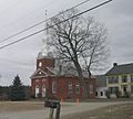
Clarendon House, Clarendon Springs
|
|

Clarendon, Vermont
|
|
| Country | United States |
| State | Vermont |
| County | Rutland |
| Communities |
|
| Area | |
| • Total | 31.6 sq mi (81.7 km2) |
| • Land | 31.6 sq mi (81.7 km2) |
| • Water | 0.0 sq mi (0.0 km2) |
| Elevation | 538 ft (164 m) |
| Population
(2020)
|
|
| • Total | 2,412 |
| • Density | 76.33/sq mi (29.523/km2) |
| Time zone | UTC-5 (Eastern (EST)) |
| • Summer (DST) | UTC-4 (EDT) |
| ZIP Codes | |
| Area code(s) | 802 |
| FIPS code | 50-14500 |
| GNIS feature ID | 1462072 |
Clarendon is a town located in Rutland County, Vermont, in the United States. In 2020, about 2,412 people lived here. Clarendon is known for its beautiful natural features. It is divided by U.S. Route 7, the Cold River, Mill River, and Otter Creek. The Green Mountains also split the town into different areas. These areas include Clarendon, West Clarendon, East Clarendon, Clarendon Springs, and North Clarendon.
Contents
Discovering Clarendon's Past
Clarendon has a long and interesting history. The first families settled in this area around 1762. Back then, it was part of Albany County, New York. Later, it became part of Charlotte County.
Around 1777, Vermont declared itself a republic. This meant it was like its own country for a while! After some disagreements about land with New Hampshire, Vermont officially became a state in 1791.
Historic Places in Clarendon
Clarendon is home to several places that are listed on the National Register of Historic Places. These are important sites that help us remember the past.
- Brown Covered Bridge – This bridge crosses the Cold River in North Clarendon. It was added to the list in 1974. Interestingly, this bridge is actually located in Shrewsbury and was damaged by floods from Hurricane Irene.
- Clarendon Congregational Church – You can find this church on Middle Road. It became a historic place in 1984.
- Clarendon House – This building is off VT 133 in Clarendon Springs. It was added in 1976. In the early 1900s, the Clarendon House was a popular spa resort. People would visit to relax and enjoy the natural springs.
- Cold River Bridge – This bridge carries VT 7B over the Cold River. It was recognized as historic in 1991.
- East Clarendon Railroad Station – Located at VT 103 and East Road, this old train station was added in 1999. Today, this former railroad station is a restaurant!
- Kingsley Covered Bridge – This bridge crosses the Mill River on East Street in East Clarendon. It was added in 1974.
-
Clarendon Congregational Church
-
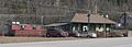
Former East Clarendon Railroad Station
-
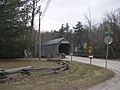
Kingsley Covered Bridge, East Clarendon


Exploring Clarendon's Geography
Clarendon covers a total area of about 31.6 square miles (81.7 square kilometers). All of this land is dry land, with no large bodies of water like lakes or big rivers within its official boundaries.
Clarendon Gorge: A Natural Wonder
One of the most popular natural spots in Clarendon is the Clarendon Gorge. You can reach it by following parts of the Appalachian Trail and the Long Trail.
To get to the waterfall and swimming holes, you need to cross a 30-foot (about 9 meters) long suspension bridge. This bridge is also a way to connect with the famous Appalachian Trail, which is a long hiking path.
Clarendon Gorge (Upper Falls) Details
- Height: The waterfall has a total drop of 8 feet.
- Water Source: The water comes from the Mill River.
- Trail Length: The trail to the falls is very short, only about 0.01 miles.
- Trail Difficulty: It's an easy walk, great for everyone!
Clarendon's Population Over Time
The number of people living in Clarendon has changed quite a bit over the years. Here's a look at how the population has grown and shrunk:
| Historical population | |||
|---|---|---|---|
| Census | Pop. | %± | |
| 1790 | 1,478 | — | |
| 1800 | 1,789 | 21.0% | |
| 1810 | 1,797 | 0.4% | |
| 1820 | 1,712 | −4.7% | |
| 1830 | 1,585 | −7.4% | |
| 1840 | 1,549 | −2.3% | |
| 1850 | 1,477 | −4.6% | |
| 1860 | 1,237 | −16.2% | |
| 1870 | 1,173 | −5.2% | |
| 1880 | 1,105 | −5.8% | |
| 1890 | 928 | −16.0% | |
| 1900 | 915 | −1.4% | |
| 1910 | 857 | −6.3% | |
| 1920 | 826 | −3.6% | |
| 1930 | 883 | 6.9% | |
| 1940 | 868 | −1.7% | |
| 1950 | 1,102 | 27.0% | |
| 1960 | 1,091 | −1.0% | |
| 1970 | 1,537 | 40.9% | |
| 1980 | 2,372 | 54.3% | |
| 1990 | 2,835 | 19.5% | |
| 2000 | 2,811 | −0.8% | |
| 2010 | 2,571 | −8.5% | |
| 2020 | 2,412 | −6.2% | |
| U.S. Decennial Census | |||
In 2000, there were 2,811 people living in Clarendon, making up 1,136 households. A household is a group of people living together. Many of these households were families.
About 31% of households had children under 18 living with them. The average household had about 2.47 people. The average family had about 2.94 people.
The population was spread out by age. About 23% were under 18. About 10% were 65 or older. The median age was 42 years old.
Learning in Clarendon
Students in Clarendon attend two main schools.

- Clarendon Elementary School serves younger students from Pre-Kindergarten up to 6th grade.
- Mill River Union High School is for older students in grades 7 through 12.

Before 2016, these schools were part of a different school system. Now, they are part of the Mill River Unified Union School District. In 2015, almost half of Clarendon's students went to the elementary school, and a little more than half went to the high school.
Famous People from Clarendon
Many interesting people have come from Clarendon, Vermont. Here are a few:
- Delino Dexter Calvin – A businessman and politician from Ontario, Canada.
- Charles V. Dyer – An abolitionist from Chicago, who worked to end slavery.
- George F. Emmons – A naval officer who explored the Antarctic.
- Theophilus Harrington – A Justice on the Vermont Supreme Court.
- George Tisdale Hodges – A United States Representative.
- Silas H. Hodges – He served as the Vermont Auditor of Accounts and a Commissioner for the U.S. Patent Office.
- Harrison J. Peck – A newspaper editor and a member of the Minnesota Senate.
- Increase Moseley – A Speaker of the Vermont House of Representatives.
- Abel Spencer – Also a Speaker of the Vermont House of Representatives.
See also
 In Spanish: Clarendon (Vermont) para niños
