Mill River (Otter Creek tributary) facts for kids
Quick facts for kids Mill River |
|
|---|---|

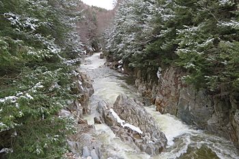
The Mill River in Clarendon Gorge during spring runoff
|
|
| Country | United States |
| State | Vermont |
| County | Rutland |
| Towns | Mount Holly, East Wallingford, Shrewsbury, Clarendon |
| Physical characteristics | |
| Main source | Mount Holly, Vermont 650 m (2,130 ft) 43°24′15″N 72°48′04″W / 43.40430°N 72.80107°W |
| River mouth | Otter Creek Clarendon, Vermont 540 ft (160 m) 43°30′23″N 72°58′33″W / 43.50629°N 72.97574°W |
| Length | 28.7 km (17.8 mi) |
The Mill River is a river in Vermont, United States. It flows for about 17.8 miles (28.7 km) through Rutland County. This river is a smaller stream that eventually flows into Otter Creek.
Exploring the Mill River
The Mill River begins its journey in the southern part of Mount Holly. This area is located west of the Okemo Mountain ski resort, high up in the Green Mountains.
River's Path
From its source, the Mill River flows mainly towards the northwest. It passes by Vermont Route 155 and then continues its path near Vermont Route 103. You can also spot the Green Mountain Railroad running alongside parts of the river.
Famous Crossing
Before the river reaches the town of Clarendon, it flows through a narrow area called Clarendon Gorge. This spot is special because the famous Appalachian Trail crosses right over the Mill River here. Hikers from all over the world use this trail!
Where the River Ends
After passing through Clarendon Gorge, the Mill River turns west and then southwest. It goes under U.S. Route 7 and finally joins Otter Creek. This meeting point is about one mile southwest of the village of Clarendon.
 | William M. Jackson |
 | Juan E. Gilbert |
 | Neil deGrasse Tyson |

