Shrewsbury, Vermont facts for kids
Quick facts for kids
Shrewsbury, Vermont
|
|
|---|---|

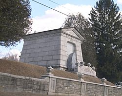
The historic Laurel Glen Mausoleum in Shrewsbury
|
|

Shrewsbury, Vermont
|
|
| Country | United States |
| State | Vermont |
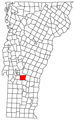
| County | Rutland |
| Communities |
|
| Area | |
| • Total | 50.2 sq mi (130.0 km2) |
| • Land | 50.1 sq mi (129.6 km2) |
| • Water | 0.1 sq mi (0.4 km2) |
| Elevation | 1,762 ft (537 m) |
| Population
(2020)
|
|
| • Total | 1,096 |
| • Density | 21.83/sq mi (8.431/km2) |
| Time zone | UTC-5 (Eastern (EST)) |
| • Summer (DST) | UTC-4 (EDT) |
| ZIP code |
05738
|
| Area code(s) | 802 |
| FIPS code | 50-65275 |
| GNIS feature ID | 1462210 |
Shrewsbury is a small town located in Rutland County, Vermont, United States. It was named after the Earl of Shrewsbury. In 2020, the town had a population of 1,096 people.
Shrewsbury was once home to Jim Jeffords, who was a U.S. Senator. The town also became famous in the 1980s. A wild moose spent 76 days trying to befriend a local farmer's cow. This unusual story even inspired a book called A Moose for Jessica.
Contents
Life in Shrewsbury: What's it Like?
Shrewsbury has a few local businesses. However, most people who live here work outside the town. Many travel to nearby Rutland for their jobs.
Education for Kids
The town has its own small school, called Shrewsbury Mountain School, for younger students. When students are ready for high school, they attend Mill River Union High School. This school is located in a nearby town called Clarendon.
Community and Safety
The community church is located in the meetinghouse in Shrewsbury Center. This building hosts fun activities like talent shows and contra dances. The local fire department is made up of volunteers. It is located in Cuttingsville. There is also a small library run by volunteers. Shrewsbury is known for being a very safe place to live.
Geography: Exploring Shrewsbury's Landscape
Shrewsbury covers an area of about 50.2 square miles. Most of this area is land, with only a small part being water. The famous Appalachian Trail and Long Trail both pass through the town. They cross it from the southwest to the northeast. Vermont Route 103 also goes through the southwestern part of the town.
Population History: How Shrewsbury Has Grown
| Historical population | |||
|---|---|---|---|
| Census | Pop. | %± | |
| 1790 | 383 | — | |
| 1800 | 748 | 95.3% | |
| 1810 | 990 | 32.4% | |
| 1820 | 1,148 | 16.0% | |
| 1830 | 1,289 | 12.3% | |
| 1840 | 1,218 | −5.5% | |
| 1850 | 1,268 | 4.1% | |
| 1860 | 1,175 | −7.3% | |
| 1870 | 1,145 | −2.6% | |
| 1880 | 1,235 | 7.9% | |
| 1890 | 974 | −21.1% | |
| 1900 | 935 | −4.0% | |
| 1910 | 751 | −19.7% | |
| 1920 | 620 | −17.4% | |
| 1930 | 540 | −12.9% | |
| 1940 | 537 | −0.6% | |
| 1950 | 464 | −13.6% | |
| 1960 | 445 | −4.1% | |
| 1970 | 570 | 28.1% | |
| 1980 | 866 | 51.9% | |
| 1990 | 1,107 | 27.8% | |
| 2000 | 1,108 | 0.1% | |
| 2010 | 1,056 | −4.7% | |
| 2020 | 1,096 | 3.8% | |
| U.S. Decennial Census | |||
In the year 2000, there were 1,108 people living in Shrewsbury. The town had 426 households. About 32.6% of these households had children under 18 living there. Most families, about 64.3%, were married couples.
The average household had about 2.53 people. The average family had about 2.90 people. The population was spread out across different age groups. About 24% of the people were under 18 years old. The median age in the town was 43 years.
The average income for a household in Shrewsbury was about $48,472 in 2000. For families, the average income was around $51,681.
Notable People from Shrewsbury
- Jim Jeffords, a former U.S. Senator.
See also
 In Spanish: Shrewsbury (Vermont) para niños
 | Selma Burke |
 | Pauline Powell Burns |
 | Frederick J. Brown |
 | Robert Blackburn |

