
Rutland (city), Vermont facts for kids
Quick facts for kids
Rutland, Vermont
|
||
|---|---|---|

Downtown Historic District
|
||
|
||
| Nickname(s):
Marble City, Gateway to Southern Vermont, Rutvegas
|
||

Location in Vermont
|
||
| Country | United States | |
| State | Vermont | |
| County | Rutland | |
| Incorporated | 1892 | |
| Area | ||
| • Total | 7.67 sq mi (19.86 km2) | |
| • Land | 7.54 sq mi (19.54 km2) | |
| • Water | 0.13 sq mi (0.33 km2) | |
| Elevation | 541 ft (165 m) | |
| Population
(2020)
|
||
| • Total | 15,807 | |
| • Density | 2,096.42/sq mi (809.64/km2) | |
| Time zone | UTC-5 (EST) | |
| • Summer (DST) | UTC-4 (EDT) | |
| ZIP codes |
05701, 05702
|
|
| Area code(s) | 802 | |
| FIPS code | 50-61225 | |

Rutland is a city in Vermont, United States. It is the only city in and the main town of Rutland County. In 2020, about 15,807 people lived there. Rutland is Vermont's third-largest city, after Burlington and South Burlington.
The city is about 65 miles (105 km) north of the Massachusetts border. It is also about 35 miles (56 km) west of New Hampshire and 20 miles (32 km) east of New York. Rutland City is completely surrounded by Rutland Town, which is a separate local government. The downtown area of Rutland is a historic district, meaning it has many old and important buildings.
Contents
History of Rutland

The area that is now Rutland was first set up as a town in 1761. It was named after John Manners, who was the 3rd Duke of Rutland. People started living there in 1770. For a while, Rutland was one of the capitals of the Republic of Vermont, before Vermont became a state.
Marble Industry in Rutland
In the early 1800s, small amounts of high-quality marble were found in Rutland. By the 1830s, a very large amount of solid marble was discovered in what is now West Rutland. Small companies began digging for marble in the 1840s. However, the marble quarries (places where stone is dug from the ground) only became very profitable after the railroad arrived in 1851.
Rutland soon became one of the world's top producers of marble. Many Italian people who knew a lot about working with marble moved to Rutland with their families. This helped the city grow a lot.
.jpg)
Becoming a City
Because of all the growth and new businesses, the center of town became Rutland village in 1886. Most of the original town was then split off into two new towns: West Rutland and Proctor. These new towns had most of the marble quarries.
Rutland City officially became Vermont's third city on November 18, 1892. The first mayor of the new city was John A. Mead.

Changes in Recent Years
In the 1980s and 1990s, the marble quarries in the area started to close down. This caused many people to lose their jobs.
Geography and Climate
Rutland is located at coordinates 43.60889 degrees North and -72.97972 degrees West.
Land and Water
The city covers about 7.67 square miles (19.86 square kilometers). Most of this area, about 7.6 square miles (19.54 square kilometers), is land. A small part, about 0.04 square miles (0.10 square kilometers), is water. Several streams and creeks flow through Rutland, including Otter Creek, Moon Brook, Tenney Brook, East Creek, and Mussey Brook.
Rutland's Weather
Rutland has a humid continental climate. This means it has long, cold, and snowy winters. The summers are warm and often wet.
The highest temperature ever recorded in Rutland was 102°F (39°C) in 2008. The lowest temperature ever recorded was -43°F (-42°C) in 1994. Usually, July is the wettest month, and February is the driest.
Getting Around Rutland
Major Roads and Highways
Rutland is Vermont's third-largest city, but it is not directly on or near the state's two main Interstate highways. However, signs for Rutland can be seen on I-91 and I-89. You can also see signs for Rutland on the Adirondack Northway (I-87) in New York.
U.S. Route 4 and U.S. Route 7 are the two main roads that lead into Rutland. They even share the same road for a short distance in the city. U.S. Route 7 connects Rutland to towns like Manchester and Bennington to the south, and Middlebury and Burlington to the north.
To the east, U.S. Route 4 goes through places like Killington and Woodstock towards New Hampshire. To the west, U.S. Route 4 has been made into a four-lane highway that goes to the New York state line, which is about 18 miles (29 km) away. This is the only highway with limited access that serves Rutland. The older route of U.S. Route 4 now has different names, like U.S. Route 4 Business and Vermont Route 4A.
Train Travel

Rutland has a train station that is an important stop for Amtrak's Ethan Allen Express train. This train offers direct service south to New York City (about 5.5 hours) and north to Burlington (about 2 hours). Other towns on this train route include Albany and Castleton.
Bus Services

Rutland has its own local bus system called "The Bus," which is run by the Marble Valley Regional Transit District. A ride on this bus costs $0.50, and there are discounts for some riders. There are five local bus routes within the city. There are also buses that go to nearby towns like Fair Haven and Middlebury.
During the winter, two special buses take tourists to ski resorts like Okemo Mountain and Killington Ski Resort. One of these is called the Diamond Express. These buses run all year. "The Bus" used to be free before 2007, when the 50-cent fare was added to help with gas costs. The main bus station is the Marble Valley Regional Transit Center downtown.
Other bus companies, like Premier Coach's Vermont Translines, also serve Rutland daily. They offer connections to places like Burlington, Lebanon, New Hampshire, and Albany, New York.
Air Travel
The Rutland–Southern Vermont Regional Airport is a public airport owned by the state. It is located about 6 miles (10 km) south of the city center in North Clarendon. The only commercial flights from this airport are three times a day by Cape Air to and from Logan International Airport in Boston, Massachusetts. From Boston, you can connect to other flights, including those with JetBlue Airways.
People of Rutland (Demographics)
| Historical population | |||
|---|---|---|---|
| Census | Pop. | %± | |
| 1880 | 7,502 | — | |
| 1890 | 8,239 | 9.8% | |
| 1900 | 11,499 | 39.6% | |
| 1910 | 13,546 | 17.8% | |
| 1920 | 14,954 | 10.4% | |
| 1930 | 17,315 | 15.8% | |
| 1940 | 17,082 | −1.3% | |
| 1950 | 17,659 | 3.4% | |
| 1960 | 18,325 | 3.8% | |
| 1970 | 19,293 | 5.3% | |
| 1980 | 18,436 | −4.4% | |
| 1990 | 18,230 | −1.1% | |
| 2000 | 17,292 | −5.1% | |
| 2010 | 16,495 | −4.6% | |
| 2020 | 15,807 | −4.2% | |
| U.S. Decennial Census | |||
In 2010, there were 16,495 people living in Rutland. There were 7,167 households and 4,209 families. The city had about 2,254 people per square mile (870 people per square kilometer).
Most of the people in Rutland (95.9%) were White. About 0.8% were African American, and 0.8% were Asian. About 1.5% of the population were Hispanic or Latino.
About 21.1% of households had children under 18 living with them. The average household had 2.22 people, and the average family had 2.80 people.
The population was spread out by age:
- 22.7% were under 18 years old.
- 7.8% were from 18 to 24 years old.
- 28.9% were from 25 to 44 years old.
- 22.4% were from 45 to 64 years old.
- 18.2% were 65 years or older.
The average age in the city was 39.3 years.
Economy and Jobs
Money in Rutland
In 2007, Rutland had $321.6 million in retail sales, which was the third highest in the state. The city used to have two shopping centers, the Rutland Mall and Diamond Run Mall.
The average income for a household in Rutland was $30,478. For a family, the average income was $41,561. About 15.4% of the people and 10.3% of families lived below the poverty line.
Main Employers
Some of the biggest employers in the Rutland area are:
- Rutland Regional Medical Center
- General Electric Aircraft Engines (GE)
- OMYA
- Green Mountain Power
- Carris Reels
GE employed 975 workers in 2010. Casella Waste Systems is another large employer, with 583 employees at its main office.
Ann Clark Cookie Cutters is a company in Rutland that makes cookie cutters.
Hospital Services
Rutland Regional Medical Center is the second-largest health care facility in Vermont. It has 188 beds for patients and 120 doctors.
Fun Things to Do in Rutland

The downtown area of Rutland is a great place to visit. It has the Rutland Free Library, the Paramount Theater, and Merchant's Row. Merchant's Row is a street with old buildings from the mid-1800s that have been fixed up. In total, 108 buildings downtown are listed on the National Register of Historic Places.
Rutland also has the 275-acre (111 ha) Pine Hill Park. This park is perfect for mountain biking, hiking, and other outdoor activities. At the park's entrance, you'll find the Flip Side Skatepark, which is a skatepark with a roof.
Events in Rutland
Rutland hosts many fun events throughout the year:
- Art in the Park
- Friday Night Live
- A Summer Farmers' Market in Depot Park
- A Winter Farmers' Market at the Vermont Farmers Food Center
- Downtown Street Party & Sidewalk Sales
- Downtown Sip and Shops
- The Summer Concert Series in Main Street Park
- The Vermont State Fair
- Rutland Winter Fest
- Green Mountain Open Bowling Tournament
The Rutland Halloween Parade has been held every year since 1960. In the 1970s, this parade was even used as the setting for some superhero comic books, including Batman and Justice League of America. The parade celebrated its 50th anniversary in 2009.
Sister City Program
Rutland has a "sister city" in Japan called Ishidoriya, Iwate. Since 1986, Rutland has had an annual exchange program called the Rutland Ishidoriya Student Exchange (R.I.S.E). Through this program, students from grades 8-11 from Rutland get to visit Ishidoriya, Japan. The money for this trip comes from fundraising. In return, five students from Ishidoriya come to Rutland each January.
Important Historic Places
Here are some historic places in Rutland that are listed on the National Register of Historic Places:
- Arthur Perkins House – 242 South Main Street (added 1988)
- Chaffee-Moloney Houses – 194 & 196-98 Columbian Avenue (added 2001)
- Clementwood – Clement Road (added 1980)
- H. H. Baxter Memorial Library – 96 Grove Street (added 1978)
- Longfellow School – 6 Church Street (added 1976)
- Proctor-Clement House – 85 Field Avenue (added 1982)
- Rutland Courthouse Historic District – U.S. 7 (added 1976)
- Rutland Downtown Historic District – (added 1980)
- Rutland Free Library – (the old post office and courthouse from 1859)
- St. Peter's Church and Mount St. Joseph Convent Complex – (added 1980)
Education in Rutland

Public Schools
Public schools in Rutland are managed by Rutland City Public Schools. These include:
- Rutland High School
- Rutland Middle School
- Allen Street Campus
- Howe Center Campus
- Rutland Intermediate School
- Northwest Primary School
- Northeast Primary School
- Stafford Technical Center
There is also a publicly funded pre-kindergarten program for families who qualify, offered through Rutland County Head Start.
Private Schools
Private schools in Rutland include:
- Christ the King School (Catholic primary school)
- Mount Saint Joseph Academy (grades 9–12, Catholic)
- Rutland Area Christian School (grades K–12)
There are also private pre-kindergarten programs like Grace Preschool and The Peanut Gallery Preschool.
Colleges
Rutland is home to the Community College of Vermont (CCV). The College of St. Joseph in Vermont used to be in the city but is now closed. Many Rutland residents also travel to nearby Castleton University, whose hockey teams practice in Rutland Town.
Media in Rutland
Newspapers
The main newspaper in Rutland is the Rutland Herald, which publishes five days a week. "Sam's Good News" is a local weekly paper that focuses on local interests. "The Mountain Times" is also available in Rutland.
Radio Stations
There are seven radio stations licensed to Rutland:
- 88.7 FM WRVT (public radio)
- 90.9 WFTF
- 94.5 WDVT (classic rock)
- 95.7 WMTZ-LP (3ABN Radio)
- 97.1 WZRT (Top 40 music)
- 98.1 WJJR (Adult Contemporary hits)
- 1380 AM WSYB
Television
Rutland is part of the Burlington / Plattsburgh television market. Comcast offers most major channels, including local Vermont PBS channel WVER (channel 28). You can also watch channels from Albany, New York, like WRGB (CBS), WTEN (ABC), and WMHT (PBS). PEGTV broadcasts local government programs on Comcast channels 15, 20, and 21.
Notable People from Rutland
- Aaron Lewis - American singer and songwriter
- John Deere (inventor) - American inventor and founder of the company John Deere
Images for kids
-
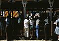
At the Vermont State Fair, Rutland, 1941, by Jack Delano

See also
 In Spanish: Rutland (Vermont) para niños
