
Fair Haven, Vermont facts for kids
Quick facts for kids
Fair Haven, Vermont
|
|
|---|---|
|
Town
|
|

Main Street
|
|

Located in Rutland County, Vermont
|
|

Location of Vermont with the U.S.A.
|
|
| Country | United States |
| State | Vermont |
| County | Rutland |
| Chartered | 1779 |
| Communities | |
| Area | |
| • Total | 18.147 sq mi (47.00 km2) |
| • Land | 17.444 sq mi (45.18 km2) |
| • Water | 0.703 sq mi (1.82 km2) |
| Population
(2020)
|
|
| • Total | 2,736 |
| • Density | 150.77/sq mi (58.212/km2) |
| • Households | 1,135 |
| • Families | 738 |
| ZIP code |
05743
|
| Area code(s) | 802 |
| Website | www.fairhavenvt.org |
Fair Haven is a town in Rutland County, Vermont, in the United States. In 2020, about 2,736 people lived there. A smaller area called Fair Haven is also located within the town. The town is known for its beautiful buildings from the late 1800s.
Contents
History of Fair Haven
.jpg)
Fair Haven was officially started on October 27, 1779. The first people settled here in the same year. The area originally included West Haven, which became its own town later in 1792. The first post office in Fair Haven opened in 1797.
In 1783, a man named Colonel Matthew Lyon moved to Fair Haven. He started building different kinds of mills near the falls on the Castleton River. He built a gristmill (for grinding grain), a sawmill (for cutting wood), and a papermill (for making paper). He also had a forge for metalwork and even started a newspaper called the Fair Haven Gazette.
This was the beginning of Fair Haven as a busy mill town. By 1859, it had many businesses. These included a marble mill, a rolling mill, a nail factory, and a papermill that made wallpaper. There were also three sawmills, a wagon shop, a machine shop, two blacksmith shops, and two shoe shops.
Slate Quarrying in Fair Haven
People started digging for and making things from slate in 1846. Fair Haven became famous for its large slate quarries. Slate is a type of rock that can be split into thin, flat pieces. People thought there was an endless supply of it! This slate was sent to cities all along the Atlantic coast and in the West. Some of it was even made into small writing slates that students used in school.
On April 7, 1880, a small part of Fair Haven became part of New York. This happened because the Poultney River changed its path. The land that moved was west of the deepest part of the river.
-
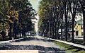
Prospect Street around 1910
-
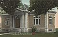
The Free Library in 1914
-
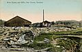
A slate quarry around 1910


Population of Fair Haven
| Historical population | |||
|---|---|---|---|
| Census | Pop. | %± | |
| 1790 | 545 | — | |
| 1800 | 411 | −24.6% | |
| 1810 | 645 | 56.9% | |
| 1820 | 714 | 10.7% | |
| 1830 | 675 | −5.5% | |
| 1840 | 633 | −6.2% | |
| 1850 | 902 | 42.5% | |
| 1860 | 1,378 | 52.8% | |
| 1870 | 2,208 | 60.2% | |
| 1880 | 2,211 | 0.1% | |
| 1890 | 2,791 | 26.2% | |
| 1900 | 2,999 | 7.5% | |
| 1910 | 3,095 | 3.2% | |
| 1920 | 2,540 | −17.9% | |
| 1930 | 2,614 | 2.9% | |
| 1940 | 2,245 | −14.1% | |
| 1950 | 2,286 | 1.8% | |
| 1960 | 2,378 | 4.0% | |
| 1970 | 2,777 | 16.8% | |
| 1980 | 2,819 | 1.5% | |
| 1990 | 2,887 | 2.4% | |
| 2000 | 2,928 | 1.4% | |
| 2010 | 2,734 | −6.6% | |
| 2020 | 2,736 | 0.1% | |
| U.S. Decennial Census | |||
In 2010, there were 2,734 people living in Fair Haven. There were 1,135 homes. The town had about 150 people per square mile. Most of the people living in Fair Haven (97.3%) were White. A small number of people were Black, Native American, or Asian. About 1.3% of the people were Hispanic or Latino.
The population was almost evenly split between males and females. About 21.9% of the people were under 18 years old. About 15.5% of the people were 65 years old or older.
Geography of Fair Haven
Fair Haven covers about 18.1 square miles. Most of this area (17.6 square miles) is land. The rest (0.5 square miles) is water. The town gets its water from the Poultney River and Castleton River.
Fair Haven's Borders
Fair Haven shares its borders with several other towns:
- To the north, it borders Benson.
- To the east, it borders Castleton.
- To the west, it borders West Haven.
- To the south and southwest, it borders Hampton, New York.
- In the southeast, it borders Poultney.
Transportation in Fair Haven
A part of U.S. Route 4 goes through Fair Haven. This highway has three exits that serve the town. Vermont Route 4A and Vermont Route 22A also pass through Fair Haven. They run on the same road for a short distance just south of the town center.
Neighboring Towns
 |
Benson | Benson | Hubbardton | |
| West Haven | Castleton | |||
| Hampton, New York | Hampton, New York | Poultney |
Places to Visit in Fair Haven
- Fair Haven Historical Society & Museum: Learn about the town's past.
- Ira C. Allen Mansion, also known as the "Marble Mansion."
Fair Haven has a large town green, which is a grassy open space. There is a fountain in the middle of the green. At the south end, you can find a gazebo, which is a small, open building.
Famous People from Fair Haven
- Erik Barnouw: A historian who studied radio and television.
- Chittenden Lyon: A US congressman from Kentucky.
- Matthew Lyon: A printer, farmer, soldier, and one of the founders of Fair Haven. He was also a US congressman.
- Joseph A. McNamara: A U.S. Attorney for Vermont.
- Benjamin F. H. Witherell: A judge.
- James Witherell: A US congressman.
See also
In Spanish: Fair Haven (Vermont) para niños
