West Rutland, Vermont facts for kids
Quick facts for kids
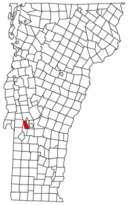
West Rutland, Vermont
|
|
|---|---|

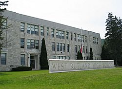
High school in West Rutland
|
|

West Rutland, Vermont
|
|
| Country | United States |
| State | Vermont |
| County | Rutland |
| NECTA | Rutland |
| Chartered | 1886 |
| Communities | |
| Area | |
| • Total | 18.0 sq mi (46.6 km2) |
| • Land | 18.0 sq mi (46.6 km2) |
| • Water | 0.0 sq mi (0.0 km2) |
| Elevation | 489 ft (149 m) |
| Population
(2020)
|
|
| • Total | 2,214 |
| • Density | 123.0/sq mi (47.51/km2) |
| Time zone | UTC-5 (Eastern (EST)) |
| • Summer (DST) | UTC-4 (EDT) |
| ZIP Codes | |
| Area code(s) | 802 |
| FIPS code | 50-82300 |
| GNIS feature ID | 1462256 |
West Rutland is a town located in Rutland County, Vermont, in the United States. In 2020, about 2,214 people lived there. The main part of the town, where most people live, is called a census-designated place (CDP) by the U.S. Census Bureau. West Rutland is also part of the larger Rutland area.
Contents
Life in West Rutland
West Rutland has many small shops and businesses. Many of these can be found on Marble Street, which is the town's main road. You can find places like Boardman Hill Farm, which even has a solar farm! There is also the Carving Studio & Sculpture Center, where artists work.
The town has a public school called West Rutland School. Kids from pre-kindergarten all the way to 12th grade go there. It is part of the Quarry Valley Unified Union School District.
History of West Rutland
West Rutland started as part of a bigger town called Rutland. In 1761, it was given as one of the New Hampshire Grants. It was named after Rutland, Massachusetts, where the first owner, John Murrey, lived. This area was great for farming because of its good land and flat areas.
In 1863, there were some protests in West Rutland. This happened after the state started a "draft," which meant people had to join the army. Later, in 1868, during a workers' strike, some Irish-Catholic workers were asked to leave their homes. Then, other workers from French-Canadian families were brought in to take their places.
West Rutland wanted to become its own town, separate from East Rutland. So, on November 19, 1886, West Rutland officially became its own town. The Marble Street Historic District was added to the National Register of Historic Places in 1990. This means it is a special place with important history.
The Marble Industry
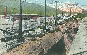
In the early 1800s, small amounts of high-quality marble were found in Rutland. By the 1830s, a very large amount of solid, good quality marble was discovered in what is now West Rutland. Small companies began working here in the 1840s. But the marble quarries (places where marble is dug out) really became successful when the railroad arrived in 1851.
Around the same time, famous marble quarries in Carrara, Italy, became harder to work in because they were too deep. Because of this, Rutland quickly became one of the top places in the world for producing marble.
The marble business helped the town grow a lot. In 1886, the marble companies helped make sure that West Rutland and Proctor became their own towns. The marble quarries in the area closed in the 1980s and 1990s. This meant many people lost their jobs. However, West Rutland has since attracted artists and families who like a quiet, country lifestyle. Because it is a very rural town, much of its economy depends on the nearby city of Rutland.
Population Information
| Historical population | |||
|---|---|---|---|
| Census | Pop. | %± | |
| 1880 | 2,379 | — | |
| 1890 | 3,680 | 54.7% | |
| 1900 | 2,914 | −20.8% | |
| 1910 | 3,427 | 17.6% | |
| 1920 | 3,391 | −1.1% | |
| 1930 | 3,421 | 0.9% | |
| 1940 | 2,922 | −14.6% | |
| 1950 | 2,487 | −14.9% | |
| 1960 | 2,302 | −7.4% | |
| 1970 | 2,381 | 3.4% | |
| 1980 | 2,351 | −1.3% | |
| 1990 | 2,448 | 4.1% | |
| 2000 | 2,535 | 3.6% | |
| 2010 | 2,326 | −8.2% | |
| 2020 | 2,214 | −4.8% | |
| U.S. Decennial Census | |||
According to the 2010 census, there were 2,326 people living in West Rutland. Most of the people living in the town were White (96.9%). There were also smaller groups of African Americans, Native Americans, and Asians. About 0.7% of the population was Hispanic or Latino.
The average age of people in West Rutland was 39 years old. About 23.8% of the population was under 18 years old.
Geography and Climate
West Rutland is located at 43°36′38″N 72°58′23″W / 43.61056°N 72.97306°W. It is about 648 feet (197 meters) above sea level. The town is made up entirely of land. The Clarendon River flows through West Rutland. The town is located between the Taconic Range and the Green Mountains.
You can get to West Rutland by roads like U.S. Route 4, Vermont Route 3, and Vermont Route 4A.
Town Center Details
The main part of West Rutland, called the town center, covers about 3.7 square miles. This is about 21% of the town's total area. Its borders are defined by roads like U.S. Route 4 and Dewey Avenue, as well as the Clarendon River and nearby town lines.
Weather in West Rutland
West Rutland has a type of weather called a "Warm Summer Continental Climate". This means it has warm summers and cold, snowy winters.
| Climate data for West Rutland, Vermont | |||||||||||||
|---|---|---|---|---|---|---|---|---|---|---|---|---|---|
| Month | Jan | Feb | Mar | Apr | May | Jun | Jul | Aug | Sep | Oct | Nov | Dec | Year |
| Mean daily maximum °F (°C) | 30 (−1) |
33 (1) |
42 (6) |
56 (13) |
68 (20) |
77 (25) |
81 (27) |
79 (26) |
71 (22) |
60 (16) |
47 (8) |
34 (1) |
57 (14) |
| Daily mean °F (°C) | 20 (−7) |
22 (−6) |
32 (0) |
45 (7) |
56 (13) |
65 (18) |
69 (21) |
68 (20) |
60 (16) |
49 (9) |
38 (3) |
26 (−3) |
46 (8) |
| Mean daily minimum °F (°C) | 11 (−12) |
12 (−11) |
22 (−6) |
33 (1) |
44 (7) |
53 (12) |
58 (14) |
56 (13) |
48 (9) |
38 (3) |
29 (−2) |
17 (−8) |
35 (2) |
| Average precipitation inches (mm) | 2.4 (61) |
2.0 (51) |
2.5 (64) |
2.8 (71) |
3.5 (89) |
3.8 (97) |
4.2 (110) |
3.8 (97) |
3.7 (94) |
3.2 (81) |
3.1 (79) |
2.5 (64) |
37.5 (950) |
| Average precipitation days | 12 | 10 | 11 | 11 | 13 | 12 | 11 | 11 | 10 | 11 | 12 | 12 | 136 |
| Source: Weatherbase | |||||||||||||
Places to Visit
- Carving Studio & Sculpture Center
- Marble Valley Players—West Rutland Town Hall Theater
- West Rutland Art Park
- The West Rutland Marsh is a special place for birdwatching. It is named an Important Bird Area by the National Audubon Society.
- West Rutland School
Notable People
Some well-known people who have lived in West Rutland include:
- Peter J. Hincks, who was the Vermont State Treasurer.
- Harvey H. Johnson, a US congressman.
- James Patrick Leamy, a judge.
- George E. Royce, a marble company executive and state Senator.
- Aldace F. Walker, who was part of the Interstate Commerce Commission and a railway president.
See also
 In Spanish: West Rutland para niños
 | John T. Biggers |
 | Thomas Blackshear |
 | Mark Bradford |
 | Beverly Buchanan |


