
Taconic Mountains facts for kids
Quick facts for kids Taconic Mountains |
|
|---|---|
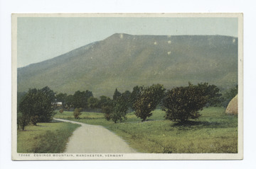
3,840’ Mount Equinox in Vermont is the high point in The Taconic range
|
|
| Highest point | |
| Peak | Equinox Mountain (Bennington County, Vermont) |
| Elevation | 3,850 ft (1,170 m) |
| Geography | |

Orogenies of the northeast United States
|
|
| Country | United States |
| State | New York, Connecticut, Massachusetts, Vermont |
| Region | western New England, eastern New York |
| Range coordinates | 42°41.5′N 73°17.1′W / 42.6917°N 73.2850°W |
| Parent range | Appalachian Mountains |
| Biome | Northern hardwood forest, Appalachian balds, Taiga, Pitch Pine/Scrub Oak uplands |
| Geology | |
| Orogeny | Taconic Orogeny |
| Age of rock | 440 million years |
| Type of rock | Thrust fault |
The Taconic Mountains or Taconic Range are a group of mountains that are part of the larger Appalachian Mountains. They stretch along the eastern edge of New York State and into parts of Connecticut, Massachusetts, and Vermont.
This mountain range is a special natural area. It includes tall peaks like Mount Equinox in Vermont, which is about 3,840 feet (1,170 meters) high. Another important peak is Mount Greylock in Massachusetts, standing at 3,489 feet (1,063 meters).
The Taconics offer hundreds of miles of trails for hiking and exploring. This includes parts of the famous Appalachian Trail, which is about 2,175 miles (3,500 kilometers) long. Over sixty areas in the Taconic Mountains are protected. These lands are looked after by government groups and non-profit organizations across the four states.
Contents
What's in a Name? The Taconic Story
The name "Taconic" comes from a Native American language. It was once spelled "Taghkanic" or "Taughannock." The meaning of the name is "in the trees." It was also used as the name of a Lenape tribal leader.
You can still find the name "Taghkanic" in eastern New York. For example, there's a small town called Taghkanic, New York. This name is used for places both inside and outside the Taconic Mountains area.
Where are the Taconic Mountains?
The Taconic Mountains start in the northwest part of Connecticut and the northeast of Dutchess County, New York. They then go through western Berkshire County, Massachusetts and nearby areas in New York. The range continues along the border of New York and Vermont, reaching the town of Brandon. After Brandon, the mountains become smaller hills and separate peaks that go north towards Burlington, Vermont. To the south, they blend into the Hudson Highlands in New York.
From the west, the land slowly rises from the Hudson River Valley in New York. This area is about 12 miles (19 kilometers) wide. It gradually goes up to the highest parts of the Taconic Mountains along New York's eastern border. To the east, the Taconic Mountains drop down steeply. They end in the valleys of the Housatonic River, the upper Hoosic River, and the larger Valley of Vermont.
The Berkshires and the Green Mountains are located to the east of the Taconics. Near their northern end, the Taconic Mountains get close to the eastern foothills of the Adirondack Mountains in Washington County, New York.

Sometimes, people in Massachusetts and Connecticut mistakenly think the Taconic Mountains are part of the Berkshires. In Vermont, they are sometimes incorrectly grouped with the Green Mountains. However, the Taconic Mountains are geologically different.
Some of the tallest peaks in the Taconic Mountains include:
- Mount Equinox in Manchester, Vermont, which is about 3,816 feet (1,163 meters) tall. This is the highest point in the range.
- Mount Greylock, which is 3,491 feet (1,064 meters) tall. This is the highest point in Massachusetts.
- Mount Frissell, which is 2,454 feet (748 meters) tall. This is the highest point in Connecticut.
The Taconic Mountains are part of a natural area called the New England-Acadian forests ecoregion.
Exploring the Sub-Ranges
The Taconic Mountains can be divided into smaller sections.
The South Taconic Range
It's a bit tricky to say exactly where the southern part of the Taconics begins. This is because they are connected to the Hudson Highlands. Some important peaks in the South Taconic Range include:
- Mount Frissell, where the highest point in Connecticut is found on its southern slope, at about 2,379 feet (725 meters).
- Bear Mountain, the highest mountain peak in Connecticut, at 2,326 feet (709 meters).
- Alander Mountain (2,239 feet or 682 meters) and Brace Mountain (2,311 feet or 704 meters).
- Mount Everett, the highest point in this southern section, at 2,624 feet (800 meters). It has special areas with pitch pine and scrub oak trees.
- Mount Fray (1,893 feet or 577 meters), which is home to the Catamount Ski Area.
Bash Bish Falls, said to be Massachusetts' tallest waterfall, is also in the South Taconic Range. The Appalachian Trail runs along the eastern side of this range. The South Taconic Trail, which is about 21.3 miles (34.3 kilometers) long, runs along the western side.
Central and Upper Hoosic River Valley
North of the Catamount Ski Area, the taller hills move a bit to the west and become less noticeable. The Green River cuts through the range here. Important peaks in this area include:
- Bald Mountain, about 1,768 feet (539 meters) tall.
- Harvey Mountain, about 2,057 feet (627 meters) tall. This mountain is part of the new Harvey Mountain State Forest in New York. It has large areas of heath plants.
- Beebe Hill, about 1,726 feet (526 meters) tall. From its firetower, you can see wide views of the Hudson River valley.
A few miles east of Harvey Mountain is Yokun Ridge. This is a clear ridge about 9 miles (14 kilometers) long. It stretches from the Massachusetts Turnpike to Pittsfield. Its elevations are usually between 1,500 and 2,000 feet (457 and 610 meters). Part of this ridge is called The Stockbridge-Yokun Ridge Reserve.
In Pittsfield, the highest part of the range shifts west again. It includes hills within Pittsfield State Forest. Here you'll find Balance Rock Park and Bates Memorial State Park. Peaks include:
- Holy Mount, about 1,968 feet (600 meters) tall. This was once a place for religious ceremonies by a former Shaker community.
- Berry Hill, about 2,200 feet (671 meters) tall. It's known for its many wild azalea plants.

North of Jiminy Peak (2,392 feet or 729 meters), the valley of Kinderhook Creek cuts through the hills. Here, the westernmost ridge has Misery Mountain and Berlin Mountain (2,818 feet or 859 meters). This ridge extends into Pownal, Vermont. The easternmost ridge ends in Williamstown, Massachusetts and is dominated by Mount Greylock (3,491 feet or 1,064 meters), the highest point in Massachusetts. Between these is the long ridge of Brodie Mountain, which is 2,621 feet (799 meters) tall. This area has three long hiking trails: the Appalachian Trail, the Taconic Crest Trail, and the Taconic Skyline Trail. It also has many smaller trails.
Southern Vermont's Peaks
North of the Massachusetts border, the Hoosic River cuts through the Taconic Range. It turns west and then south towards the Hudson River. Its smaller rivers near Bennington, Vermont also shape the land. Mount Anthony, about 2,320 feet (707 meters) tall, is a separate peak here. It's known for its caves and is where Southern Vermont College is located.
North of Bennington, the range gradually gets taller. It reaches its highest points with peaks like:
- Mount Equinox, about 3,850 feet (1,173 meters) tall. This is the highest point of the Taconic Mountains.
- Dorset Mountain, about 3,770 feet (1,149 meters) tall. This is on the New England 100 Highest list.
- Grass Mountain, about 3,109 feet (948 meters) tall. This is on the New England Fifty Finest list.
- Mount Aeolus, about 3,230 feet (985 meters) tall. This mountain has old marble quarries. It's also home to Aeolus Cave, an important place where bats sleep for the winter (a hibernaculum).
You can find hiking trails on Mount Equinox, Dorset Mountain, Mount Aeolus, and other peaks in this area.
The Northern End of the Range
Just north of Danby, Vermont, the Taconic Range becomes wider and shorter for a while. It has several parallel ridges. To the west, mountains made of slate and similar rocks are most noticeable. This includes the ridge of Saint Catherine Mountain, about 1,200 feet (366 meters) tall. It has a clear 5-mile (8-kilometer) long cliff face that you can see from Wells and Poultney. The area around Lake Saint Catherine has many slate quarries.
To the east, a ridge made of schist and phyllite dominates. This is the 7-mile (11-kilometer) long cliff of Tinmouth Mountain, about 2,835 feet (864 meters) tall. It overlooks the Valley of Vermont in the town of Tinmouth. Between these two peaks are other less distinct ridges and peaks.
Near the end of the range, around Rutland, Vermont, the Taconic Mountains have several prominent peaks. They have dramatic, uneven cliff faces that are easy to see from U.S. Route 4 west of Rutland. These include:
- Herrick Mountain, about 2,726 feet (831 meters) tall.
- Grandpa's Knob, about 1,976 feet (602 meters) tall. This was once the site of the Smith–Putnam wind turbine, the first large-scale wind turbine to produce electricity.
- Bird Mountain (also called Birdseye Mountain), a butte-like peak about 2,216 feet (675 meters) tall. It's home to the Bird Mountain Wildlife Management Area. It's also an important place for raptor migration and nesting.
Also part of the Taconic Mountains are the foothills of the Lake Bomoseen region. This area is west of Birdseye and Grandpa's Knob. It's known for its many slate quarrying operations. North of Grandpa's Knob, the Taconic Range soon becomes scattered hills. These hills extend north into the Burlington, Vermont region. Some isolated peaks in this area are:
- Snake Mountain, about 1,281 feet (390 meters) tall. This is a Nature Conservancy preserve with rare and endangered species.
- Mount Philo, about 968 feet (295 meters) tall. This is home to Mount Philo State Park, which has a campground on its top.
How the Taconic Mountains Were Formed
The Taconic mountain range was created when the North American Plate crashed into a volcanic island arc. This was like what you see in modern-day Taiwan. This happened during the late Ordovician period, about 440 million years ago. Similar events later helped build the other mountain ranges to the east.
The western side of the Taconics rises slowly from hills in eastern New York. It then forms a sharp mountain crest along the western border of the New England states. The eastern side of the Taconics drops off quickly. River valleys separate it from the Berkshires and Green Mountains. The entire range is about 200 miles (320 kilometers) long. Its width changes from 5 to 20 miles (8 to 32 kilometers).
The Taconic Mountains are a specific physiographic section of the larger New England province. This province is part of the even larger Appalachian physiographic division.
Natural Resources and Industries
For a long time, getting natural resources from the Taconic Mountains was an important industry. These industries included mining for marble, limestone, slate, and iron. People also cut down trees for logging and made charcoal from wood.
Protecting the Taconic Mountains
A narrow strip along the western border of Massachusetts has been chosen by the U.S. Forest Service for possible conservation. This area is called the "Taconic Mountains Forest Legacy Area." It's part of a program that helps protect forests. This protected area is usually about a mile wide east of the state line. However, it's much wider in the southern Taconics and the middle part of Berkshire County.
Areas in New York State and Connecticut next to this region have similar protections. These federal programs offer money to buy conservation easements when they are available. This helps keep the land natural. Groups working together to protect the Taconic Mountains include the New England Wildlands and Woodlands Collaborative. This group works on a plan for conservation in the New England states. The Taconic Crest Project is another example. It involves New York, Massachusetts, and Vermont, working with local land trusts and The Nature Conservancy.
Images for kids
-
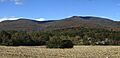
Misery Mountain (left) and Berlin Mountain (right) seen from the east in South Williamstown, MA
See also
 In Spanish: Montañas Tacónicas para niños
