Taghkanic, New York facts for kids
Quick facts for kids
Taghkanic, New York
|
|
|---|---|

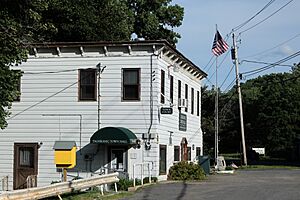
Town hall
|
|

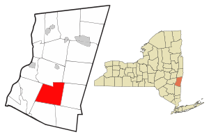
Location of Taghkanic, New York
|
|
| Country | United States |
| State | New York |
| County | Columbia |
| Government | |
| • Type | Town Council |
| Area | |
| • Total | 40.14 sq mi (103.96 km2) |
| • Land | 39.97 sq mi (103.53 km2) |
| • Water | 0.17 sq mi (0.43 km2) |
| Elevation | 564 ft (172 m) |
| Population
(2020)
|
|
| • Total | 1,231 |
| • Density | 30.668/sq mi (11.841/km2) |
| Time zone | UTC-5 (Eastern (EST)) |
| • Summer (DST) | UTC-4 (EDT) |
| FIPS code | 36-021-73077 |
| GNIS feature ID | 0979540 |
Taghkanic is a town in Columbia County, New York, United States. It is located in the south-central part of the county. The name "Taghkanic" is an older way to spell "Taconic".
About 1,231 people lived in Taghkanic in 2020. This was a small decrease from 1,310 people in 2010.
Contents
History of Taghkanic
People started living in this area before the year 1700. At that time, it was part of a large estate called Livingston Manor.
The town of Taghkanic was officially created in 1803. It was formed from a part of the nearby town of Livingston. When it was first created, it was called the town of Granger.
Where is Taghkanic?
Taghkanic covers a total area of about 104 square kilometers (40.14 square miles). Most of this area is land, with only a small amount of water.
The town is named after Taghkanic Creek. This creek flows through the town in a U-shape, from the northeast to the northwest. The town also shares its name with the Taconic Mountains, which are in the eastern part of the area.
The Taconic State Parkway is a major road that goes through the town.
People of Taghkanic
The number of people living in Taghkanic has changed over many years. Here is a look at the population from 1820 to 2020:
| Historical population | |||
|---|---|---|---|
| Census | Pop. | %± | |
| 1820 | 3,600 | — | |
| 1830 | 1,654 | −54.1% | |
| 1840 | 1,674 | 1.2% | |
| 1850 | 1,539 | −8.1% | |
| 1860 | 1,717 | 11.6% | |
| 1870 | 1,485 | −13.5% | |
| 1880 | 1,308 | −11.9% | |
| 1890 | 1,062 | −18.8% | |
| 1900 | 894 | −15.8% | |
| 1910 | 771 | −13.8% | |
| 1920 | 666 | −13.6% | |
| 1930 | 683 | 2.6% | |
| 1940 | 604 | −11.6% | |
| 1950 | 575 | −4.8% | |
| 1960 | 727 | 26.4% | |
| 1970 | 804 | 10.6% | |
| 1980 | 1,101 | 36.9% | |
| 1990 | 1,111 | 0.9% | |
| 2000 | 1,118 | 0.6% | |
| 2010 | 1,310 | 17.2% | |
| 2020 | 1,231 | −6.0% | |
| U.S. Decennial Census 2020 | |||
In 2000, there were 1,118 people living in Taghkanic. These people lived in 461 households. About 325 of these households were families.
The average household had about 2.39 people. The average family had about 2.82 people.
The population included people of different ages. About 20.8% were under 18 years old. About 19.0% were 65 years old or older. The average age in the town was 45 years.
Communities and Locations in Taghkanic
Taghkanic has several smaller communities and interesting places:
- Churchtown – This is a small community located at the edge of the town, in the northeastern part.
- East Taghkanic – Another small community found in the eastern section of the town. It is southeast of the main Taghkanic community.
- Lake Taghkanic State Park – Part of this state park is located at the southern border of the town. It is a popular place for outdoor activities.
- New Forge – This community is in the southern part of the town. The historic House at New Forge was added to the National Register of Historic Places in 1987.
- Taghkanic – This is the main community, located near the center of the town. It shares the same name as the town itself.
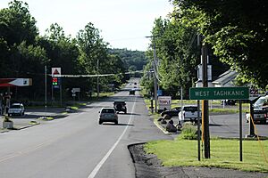
- West Taghkanic – A community located southwest of the main Taghkanic community. It used to be known by other names like "Millers Corners" and "Laphams."
See also
 In Spanish: Taghkanic (Nueva York) para niños
 | Shirley Ann Jackson |
 | Garett Morgan |
 | J. Ernest Wilkins Jr. |
 | Elijah McCoy |


