
Berkshires facts for kids
Quick facts for kids Berkshires |
|
|---|---|
| Berkshire Hills, Berkshire Mountains, The Berks | |
 |
|
| Highest point | |
| Peak | Crum Hill |
| Elevation | 2,841 ft (866 m) |
| Dimensions | |
| Length | 98 mi (158 km) north-south |
| Geography | |

Berkshires labeled as B
|
|
| Country | United States |
| Range coordinates | 42°10′0.325″N 73°8′58.385″W / 42.16675694°N 73.14955139°W |
| Geology | |
| Type of rock | Metamorphic |
The Berkshires are a beautiful highland area in western Massachusetts and northwest Connecticut. When people talk about the "Berkshires," they usually mean the part of the Green Mountains (which start in Vermont) that stretches into western Massachusetts. The part that goes into northwest Connecticut is often called the Northwest Hills or Litchfield Hills.
This region is also known as the Berkshire Hills, Berkshire Mountains, or Berkshire Plateau. It's a popular place for visitors because of its music, arts, and outdoor activities. Geologically, these mountains are part of the larger Appalachian Mountains range.
The Berkshires were even named one of the "12 Last Great Places" by The Nature Conservancy, an organization that protects important natural areas.
Contents
What are the Berkshires?
The name "The Berkshires" can mean slightly different things depending on if you're talking about politics, culture, or geography.
Political Definition
Politically, Berkshire County, Massachusetts, was set up in 1761. It covers the far western part of Massachusetts. Its western edge borders New York, and its eastern edge generally follows the natural divide between the Connecticut River watershed and the Housatonic River and Hoosic River watersheds.
Cultural Definition

Culturally, the "Berkshires" includes all the highland areas in western Massachusetts, west of the Connecticut River and the lower Westfield River. This cultural area also includes the Taconic Mountains, which border New York. Even though the Taconic Mountains formed differently, people often group them with the Berkshires culturally. Sometimes, parts of southwest Vermont and the Taconic region of New York are also included in this cultural idea of the Berkshires.
Sir Francis Bernard, who was the royal governor of Massachusetts from 1760 to 1769, named the area "Berkshire." He did this to honor his home county in England, which was also called Berkshire.
Geographic Definition

Geographically, the Berkshires are like a southern extension of the Green Mountains in Vermont. They are only different because they are a bit lower and are on the Massachusetts side of the border. In terms of physical land, the Berkshires stretch from the Housatonic River and Hoosic River valleys in western Massachusetts, to the Connecticut River valley in north-central Massachusetts, and down to the lower Westfield River valley in south-central Massachusetts. In Connecticut, where they are called the Litchfield Hills, they extend east from the upper Housatonic River valley in the northwest part of the state.
Geologically, the Berkshires are bordered on the west by the Taconic Mountains and the marble valleys of the Hoosic and Housatonic Rivers. To the east, they are bordered by the Metacomet Ridge. The Berkshires are generally about 1,000 ft (300 m) lower than the Green Mountains. They form a wide, hilly plateau with peaks and valleys cut by rivers. The land generally gets lower and less steep as you go from west to east and from north to south, except where rivers have carved deep gorges.
How the Berkshires Formed
The Berkshires and the Green Mountains began to form over 500 million years ago. This happened when the continent of Africa slowly collided with North America. This huge collision pushed up the Appalachian Mountains and created the solid rock foundation of the Berkshires. Over hundreds of millions of years, wind and water slowly wore these tall mountains down to the hills we see today.
How High are the Berkshires?
The average height of the Berkshires region is about 700 to 1,200 feet (210 to 370 m) above sea level. One of the high points is Spruce Mountain, at 2,710 feet (830 m). The very highest point in the Berkshires is Crum Hill, which is 2,841 feet (866 m) tall and located in the town of Monroe.
Rivers in the Berkshires
Many rivers flow through the Berkshires. In Massachusetts, the main rivers are the Housatonic River, Hoosic River, Westfield River, and Deerfield River. In Connecticut, the major rivers include the Farmington River, the Naugatuck River, the Shepaug River, and the Housatonic River.
Counties in the Berkshires
The Berkshire hills pass through several counties:
- Berkshire County, Massachusetts (towns east of the Housatonic River)
- Hartford County, Connecticut (towns like Hartland and Granby)
- Franklin County, Massachusetts (western part)
- Hampden County, Massachusetts (towns like Tolland, Chester, Granville, and Blandford)
- Hampshire County, Massachusetts (western part)
- Litchfield County, Connecticut (towns east of the Housatonic River)
Main Towns in the Berkshires
Some of the largest towns and cities in the Berkshires cultural region are Pittsfield, North Adams, Great Barrington, Williamstown, Stockbridge, Lee, and Lenox, Massachusetts.
History of the Berkshires
During the American Revolution, a group of soldiers led by Henry Knox achieved an amazing feat. They moved captured cannons from Fort Ticonderoga (in New York) all the way to Boston. They used ox-drawn sleds to pull the heavy cannons south along the Hudson River to Albany, then crossed the river and continued east through the Berkshires. This incredible journey, known as the "Noble train of artillery", happened in the middle of winter in 1775-1776.
The Berkshires is also home to Hancock Shaker Village. This is the oldest continuously working farm in the Berkshires. It's a historic site covering 750 acres with 20 original Shaker buildings and over 22,000 Shaker artifacts. It's listed on the National Historic Register and is one of the best places in the world to learn about the Shaker community.
Nature and Wildlife

The Berkshires are part of a larger natural area called the New England/Acadian forests ecoregion. This means it's a large area with similar types of plants, animals, and ecosystems.
The U.S. Environmental Protection Agency has divided this area into six smaller ecoregions, each with its own unique habitats.
Many parts of the Hoosic and Housatonic River valleys have limestone and marble rock underneath. This creates special wetlands with alkaline (not acidic) water. These wetlands support many different plants and animals that can't live in more acidic water. Some of these species are even rare or endangered! Combined with the rich forests, the Berkshires have a very valuable and diverse ecosystem.
Today, many groups are working hard to protect and manage this region. They want to keep its amazing natural diversity while also allowing people to live and develop sustainably. You can learn more about the nature of the Berkshires online.
Fun Things to Do in the Berkshires
The Berkshires offer many outdoor activities and cultural attractions. There are numerous trails, including part of the famous Appalachian Trail. You can also find large areas of wilderness and parks like the Berkshire Botanical Garden and Hebert Arboretum. Don't miss Bash Bish Falls, which is the tallest waterfall in Massachusetts!
The Berkshires are also well-known as a center for visual and performing arts. Many art museums are located here, including the Norman Rockwell Museum, the Clark Art Institute, the Massachusetts Museum of Contemporary Art (Mass MoCA), Berkshire Museum, and the Williams College Museum of Art (WCMA).
For performing arts, you can visit:
- Tanglewood Music Center in Lenox, which is the summer home of the Boston Symphony Orchestra.
- The Bang on a Can Summer Festival for modern music in North Adams.
- Shakespeare & Company in Lenox, which performs plays by William Shakespeare.
- Summer theater festivals like the Williamstown Theatre Festival in Williamstown, Barrington Stage Company in Pittsfield, the Berkshire Theatre Festival in Stockbridge, and Berkshire Playwrights Lab in Great Barrington.
- America's first and longest-running dance festival, Jacob's Pillow, in the town of Becket.
Images for kids
-
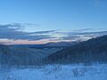
A winter view of the Berkshires.
-
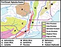
Map showing the Berkshires (labeled B) within the Appalachian Mountains.
See also
 In Spanish: Berkshires para niños
