Metacomet Ridge facts for kids
Quick facts for kids Metacomet Ridge |
|
|---|---|
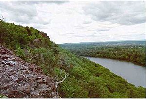
Traprock cliffs on Chauncey Peak, Connecticut
|
|
| Highest point | |
| Peak | Mount Toby |
| Elevation | 1,269 ft (387 m) |
| Dimensions | |
| Length | 100 mi (160 km) north–south |
| Geography | |
| Country | United States |
| Geology | |
| Formed by | Fault blocking |
| Age of rock | Triassic and Jurassic |
| Type of rock | Igneous and sedimentary |
The Metacomet Ridge is a long, narrow chain of mountains in southern New England. It's famous for its tall cliffs, amazing views, and special ecosystems. These ecosystems are like mini-worlds with rare plants and animals.
This ridge is a super important place for outdoor fun! It's close to over 1.5 million people, offering many hiking trails and parks. People work hard to protect the Metacomet Ridge because it's so valuable for nature, history, and recreation.
The Metacomet Ridge stretches about 100 miles (160 km). It starts in Branford, Connecticut, near Long Island Sound. Then it goes through the Connecticut River Valley in Massachusetts. It ends near the Vermont and New Hampshire borders.
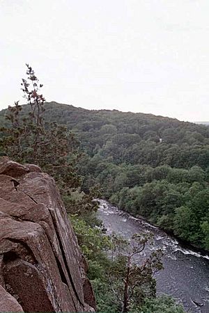
This ridge is different from the nearby Appalachian Mountains. It's made of volcanic rock called basalt (also known as trap rock) and sedimentary rock. These rocks are stacked in tilted layers, hundreds of feet thick. The basalt layers are usually the most visible ones. The ridge rises sharply from the flat valleys around it. Its highest point is about 1,200 feet (366 m) above sea level.
Contents
What is the Metacomet Ridge?
Visually, the Metacomet Ridge looks like one continuous mountain range. It runs from Long Island Sound in Branford, Connecticut, all the way to Belchertown, Massachusetts. This is a distance of about 71 miles (114 km). Only major rivers like the Farmington River and Connecticut River cut through it.
Scientists first identified it in 1985 as a single geological feature. It's mostly made of trap rock. A 2004 report for the National Park Service said the ridge includes all the traprock mountains from Long Island Sound to the Pocumtuck Range in Greenfield, Massachusetts.
How did the Metacomet Ridge get its name?
For a long time, the official U.S. Board on Geographic Names didn't have a name for the whole ridge. Geologists often called it "the traprock ridge."
The name Metacomet Ridge was first used in 1985. It came from the Metacomet Trail, a hiking path that runs along a big part of the ridge in Connecticut.
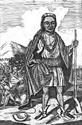
The name "Metacomet" or "Metacom" comes from a Native American leader. He was a 17th-century sachem (chief) of the Wampanoag people. He led his people during King Philip's War. Many places on the ridge are named after him, like the Metacomet Trail and King Philip's Cave. Legend says Metacomet watched the burning of Simsbury, Connecticut, from Talcott Mountain.
Where is the Metacomet Ridge located?
The Metacomet Ridge starts in New Haven, Connecticut. It begins as two parallel ridges. The western ridge includes West Rock Ridge and Sleeping Giant. It continues for about 16 miles (26 km).
To the east, the ridge starts at Beacon Hill in Branford, Connecticut. It goes north for 60 miles (97 km) to Mount Tom in Holyoke, Massachusetts. Then it turns east to form the Holyoke Range. This range continues for 10 miles (16 km) before ending in Belchertown, Massachusetts.
North of Mount Tom, the traprock layers become less common. The ridge still exists, but it's mostly low hills. The Metacomet Ridge gets taller again with the Pocumtuck Range. This includes Sugarloaf Mountain and Mount Toby. Mount Toby is the highest point of the Metacomet Ridge, at 1,269 feet (387 m).
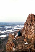
In Connecticut, the highest point is West Peak of the Hanging Hills, at 1,024 feet (312 m). In Massachusetts, the highest traprock peak is Mount Tom, at 1,202 feet (366 m).
The Metacomet Ridge is very narrow in some places, less than 0.5 miles (1 km) wide. But in other areas, with its low parallel hills, it can be up to 10 miles (16 km) wide. Many rivers flow from the Metacomet Ridge, including the Connecticut River.
The ridge is surrounded by forests, farms, and towns. It's close to big cities like New Haven, Hartford, and Springfield.
How was the Metacomet Ridge formed?
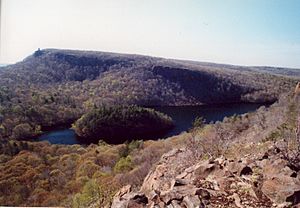
The Metacomet Ridge was formed about 200 million years ago. This happened when the North American continent started to pull away from Europe and Africa. This pulling apart created huge cracks, or faults, in the Earth.
Massive amounts of hot, liquid rock called lava flowed out of these cracks. These lava flows were hundreds of feet thick. This lava cooled and hardened into basalt, also known as traprock. The Metacomet Ridge is essentially a very old rift valley. It was once a branch of the big rift that later became the Atlantic Ocean.
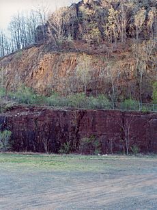
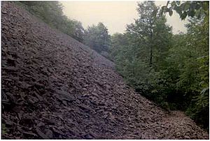
Basalt is a dark volcanic rock. When it's exposed to air and water, the iron in it rusts, giving it a reddish-brown color. Basalt often breaks into cool shapes like octagons and pentagons. You can see piles of broken basalt rocks, called talus, at the bottom of many cliffs along the ridge.
The lava flows that created the Metacomet Ridge happened over 20 million years. Between these eruptions, layers of sand and mud were deposited. These layers eventually turned into sedimentary rock. So, the ridge is like a "layer cake" of basalt and sedimentary rock.
Later, these layers broke and tilted upwards. Over time, softer sedimentary layers wore away faster than the hard basalt. This left the tilted edges of the basalt exposed, creating the steep cliffs we see today.
You can see this "layer cake" on Mount Norwottuck in the Holyoke Range. The top of Norwottuck is basalt. Below it are the Horse Caves, a deep overhang where the softer sedimentary rock has eroded away.
Mount Sugarloaf, Pocumtuck Ridge, and Mount Toby also show this layering. Mount Sugarloaf is made of arkose sandstone. Pocumtuck Ridge is mostly volcanic traprock. Mount Toby is made of a sedimentary rock called Mount Toby Conglomerate. Earthquakes tilted these layers, and then erosion created these three distinct mountains. Even though Mount Toby and Mount Sugarloaf aren't traprock, they are part of the Metacomet Ridge because they formed from the same ancient processes.
West Rock in New Haven, Connecticut, is special. It wasn't formed by lava flowing over the surface. Instead, it's the remains of a huge volcanic dike. This was a crack through which lava flowed up to the surface.
Besides the cool rock formations, the sedimentary rocks of the ridge have amazing fossils. These include dinosaur tracks from the Triassic and Jurassic periods. At Dinosaur State Park and Arboretum in Rocky Hill, Connecticut, you can see over 2,000 well-preserved dinosaur footprints!
What kind of plants and animals live here?
The Metacomet Ridge has special microclimates, which are like tiny weather zones. The dry, hot upper ridges have oak savannas, with chestnut oak trees and different grasses. Eastern red-cedar trees, which like dry places, grow on the cliff edges.
The slopes behind the ridges have plants similar to those in the nearby Appalachian Mountains. These include trees found in northern hardwood and oak-hickory forests. Deep, narrow ravines are cool and damp, with Eastern hemlock trees. The rocky slopes are rich in nutrients and have many plants that are rare in the area.
The miles of high cliffs are perfect homes for raptors (birds of prey). The Metacomet Ridge is also a path for raptors migrating (traveling) during certain seasons.
Because the ridge has so many different types of land, many species reach the northern or southern edge of their natural range here. Some plants and animals found on the ridge are rare globally. Examples include the prickly pear cactus, peregrine falcon, northern copperhead snake, and several types of rare orchids like the showy lady's slipper and ram's–head lady's slipper.
The Metacomet Ridge is also an important source of water. It provides drinking water for many towns and cities. You can find reservoirs (water storage areas) on mountains like Talcott Mountain and the Hanging Hills in Connecticut.
What is the history of the Metacomet Ridge?
Early Native American History
Native Americans lived in the river valleys around the Metacomet Ridge for at least 10,000 years. Tribes like the Quinnipiac and Pocomtuc lived here. They used traprock to make tools and arrowheads. They hunted, gathered plants, and fished. They also burned parts of the forests to grow crops like corn and squash.
Native Americans also wove the ridge into their spiritual beliefs. Stories tell of a giant stone spirit named Hobbomock. He was said to have changed the course of the Connecticut River. Hobbomock was also believed to have killed a giant human-eating beaver that lived in a huge lake in the Connecticut River Valley. The beaver's body supposedly became the Pocumtuck Ridge. Later, Hobbomock was punished to sleep forever as the Sleeping Giant mountain.
Some of these legends might have a scientific basis. The "great lake" could have been Lake Hitchcock, which existed 10,000 years ago after glaciers melted. The "giant beaver" might have been a real prehistoric beaver species, Castoroides ohioensis, which was as big as a bear! Many places on the Metacomet Ridge still have names from Native American languages.
European Settlement and Industry
Europeans started settling around the Metacomet Ridge in the mid-1600s. They cut down or burned forests to create farms. By the 1800s, most of the forests in southern New England were gone. The steep Metacomet Ridge wasn't good for farming, but its trees were cut for the charcoal industry. Charcoal was a major fuel source before coal mining became popular.
Sometimes, ridgetop forests burned when fires started on lower lands. Some uplands were used for grazing animals. Traprock was taken from the ridge to build house foundations. Copper was even found and mined at the base of Peak Mountain by prisoners.
In the 1800s, with the rise of industrialization, rivers near the ridge were dammed for power. More logging happened to fuel mills. Traprock and sandstone were quarried from the ridge. These rocks were used for paving roads and building brownstone buildings.
The Rise of Recreation
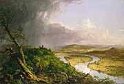
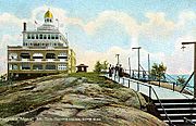
As cities grew, people started to appreciate nature more. This led to a movement called transcendentalism. Artists like Thomas Cole and writers like Henry David Thoreau celebrated nature's beauty. The Metacomet Ridge changed from a resource for industry to a place for fun and relaxation.
From the mid-1880s to the early 1900s, hotels, parks, and summer homes were built on the mountains. Famous places included hotels on Mount Holyoke, Mount Tom, and Sugarloaf Mountain. Parks like Hubbard Park were designed as peaceful escapes from city life.
Even though people later started visiting more remote places, the history of recreation on the Metacomet Ridge helped conservation efforts. Old estates became museums, and hotel lands became state parks.
Building Trails and Protecting Land
Organizations like the Connecticut Forest and Park Association started building hiking trails. In 1928, they created the Quinnipiac Trail on the Metacomet Ridge. Soon after, the Metacomet Trail was built. By the end of the 20th century, over 700 miles (1,127 km) of "blue blaze trails" were completed in Connecticut.
In the late 1950s, the Metacomet-Monadnock Trail was created. It follows the Metacomet Ridge for a third of its length. Building these trails helped people become more aware of the importance of protecting the Metacomet Ridge.
Modern Challenges and Conservation
For a long time, the Metacomet Ridge's steep, rocky terrain made it hard to build on. But with modern construction, people started wanting homes on the ridge for its views. Cities near the ridge, like New Haven and Hartford, have large populations. Towns around the ridge have also grown a lot.
This growth has led to more building on and around the Metacomet Ridge. Quarry operations, which dig out stone for construction, have also damaged parts of the ridge. For example, parts of Round Mountain have been completely removed by quarrying. The famous "head" of the Sleeping Giant mountain also has quarry scars. Local citizens worked hard to stop mining there.
Because of these threats, many groups are working to protect the Metacomet Ridge. They buy land, get land donations, and create agreements to limit development. The ridgeline from North Branford, Connecticut, to Belchertown, Massachusetts, is even being studied for a new National Scenic Trail.
In 1998, the Metacomet Ridge Conservation Compact was created in Connecticut. This agreement helps local towns protect the ridge. Most of the towns along the ridge signed this pact, promising to work towards its protection.
Fun things to do on the Metacomet Ridge

The Metacomet Ridge is a great place for outdoor activities. Its steep cliffs and amazing views make it a popular spot. There are over 200 miles (322 km) of hiking trails!
Some famous trails in Connecticut include the 51-mile (82 km) Metacomet Trail and the 50-mile (80 km) Mattabesett Trail. In Massachusetts, you can find the 110-mile (177 km) Metacomet-Monadnock Trail.
You can do many activities on the ridge, like rock climbing, bouldering, fishing, boating, and swimming. In winter, people enjoy backcountry skiing and cross-country skiing. You can also go trail running, bicycling, mountain biking, snowshoeing, birdwatching, and picnicking.
The Metacomet Ridge has many state parks, nature preserves, and conservation areas. Some parks have roads with scenic views that you can drive, bike, or ski on. These include Mount Sugarloaf State Reservation and Mount Tom State Reservation. Camping and campfires are usually not allowed on most of the ridge. You can also find museums, historic sites, and visitor centers nearby. Some even host outdoor concerts and festivals!
Images for kids
 | James Van Der Zee |
 | Alma Thomas |
 | Ellis Wilson |
 | Margaret Taylor-Burroughs |


