
Sugarloaf Mountain (Massachusetts) facts for kids
Quick facts for kids Sugarloaf Mountain (South Sugarloaf and North Sugarloaf) |
|
|---|---|

South and North Sugarloaf viewed from Mt. Toby
|
|
| Highest point | |
| Elevation | 652 ft (199 m) and 791 ft (241 m) |
| Geography | |
| Location | South Deerfield, Massachusetts |
| Parent range | Pocumtuck Range/ Metacomet Ridge |
| Geology | |
| Age of rock | 210 million yrs. |
| Mountain type | Fault-block; sedimentary |
| Climbing | |
| Easiest route | Auto road |
Sugarloaf Mountain (also called Mount Sugarloaf) is a mountain in South Deerfield, Massachusetts, United States. It looks like a flat-topped hill and has two main peaks: North Sugarloaf Mountain (about 241 meters or 791 feet tall) and South Sugarloaf Mountain (about 199 meters or 652 feet tall).
The mountain's cliffs are made of a type of rock called arkose sandstone. These cliffs stand out in the landscape and can be seen from far away. Even though Sugarloaf Mountain is not as tall as the Berkshire Mountains to its west, its dramatic cliffs rise about 150 to 180 meters (500 to 600 feet) from the nearby Connecticut River. This makes it a popular place for tourists and hikers. Sugarloaf Mountain is the southern end of the Pocumtuck Range.
Contents
Why Is It Called Sugarloaf Mountain?

The name sugarloaf comes from the cone shape that sugar used to be molded into for shipping a long time ago. Both Sugarloaf Mountain and Mount Sugarloaf are used to describe this mountain. The USGS and hiking maps usually call it Sugarloaf Mountain. However, the state park that includes the mountain is called the Mount Sugarloaf State Reservation. Sometimes, Mount Sugarloaf refers only to the south peak, and the north peak is called the Pocumtuck Ridge. People living nearby use both names.
The original name for the mountain from the Native American people was Wequamps (or Wequomps). This name means "at the point" or "at the end," and it was used for places that were stopping points.
The Giant Beaver Myth
According to an old Native American story, Sugarloaf Mountain is the body of a giant beaver. This beaver used to eat people and lived in a large lake where the Connecticut River is now. The people asked the god Hobomok for help because the beaver was taking all their food. Hobomok decided to kill the beaver using a big tree as a club. After a big fight, the beaver died, sank to the bottom of the lake, and turned into stone, becoming Sugarloaf Mountain.
This story might have some truth to it! About 15,000 years ago, after the Ice Age, the Connecticut River valley was a huge lake called Lake Hitchcock. Also, a type of giant beaver, as big as a black bear, lived in North America around that time.
How Sugarloaf Mountain Was Formed
Sugarloaf Mountain is connected to the Pocumtuck Ridge to its north. It is made of Triassic arkose sandstone and conglomerate rock. The Sugarloaf arkose rock formed in a rift valley, which is a long, narrow valley created when the Earth's crust pulls apart. This rift valley is part of a larger area where the Earth's crust stretched from Long Island Sound up into Vermont and New Hampshire.
The Sugarloaf arkose is about 2,000 meters (6,560 feet) thick. It was formed by rivers and floods. Above it are about 50 meters (164 feet) of lake deposits. These lake deposits are covered by about 80 meters (262 feet) of basalt lava flows, which can be seen clearly in the Pocumtuck Ridge to the north. Above the basalt are other rock layers, including the Turners Falls Sandstone and the Mt. Toby Conglomerate. Mount Toby, which gives its name to the Mt. Toby Conglomerate, is located right across the Connecticut River from Sugarloaf Mountain.
About 200 million years ago, the continent of North America began to split away from Africa and Eurasia. This splitting caused many cycles of erosion (wearing away of rock) and deposition (laying down of new rock layers), along with basalt lava flows. This created the "layer cake" look of the mountain. Earthquakes and faulting tilted these layers. Later, erosion and glacial activity exposed the tilted layers of sandstone, basalt, and strong conglomerate rock that we see today.
Fun Activities at Sugarloaf Mountain

You can drive up to the summit of South Sugarloaf on a road that is open from late spring through the fall foliage season. There is also a small observation tower at the top that is open seasonally. Several steep hiking trails, including the 20-mile (32 km) Pocumtuck Ridge Trail, make the mountain a popular spot for hikers.
Most of the mountain is protected as part of the Mount Sugarloaf State Reservation. You can easily get there from Route 116. It's only about a 15-minute drive from the University of Massachusetts Amherst campus. There is parking at the bottom of the mountain and at the top of the paved road that leads to the South Sugarloaf summit. It's free to hike the trails or walk or bike up the road, but there is a small fee for cars. North Sugarloaf Mountain can only be reached by foot. There's a small cave just below its summit ledges.
Sugarloaf Mountain in Movies
In the fall of 2008, parts of the Mel Gibson film Edge of Darkness were filmed at the summit of South Sugarloaf. The observation tower was changed temporarily for the movie.
Images for kids
-
South and North Sugarloaf viewed from Mt. Toby
-
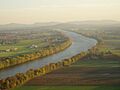
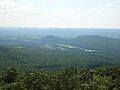
View of the Connecticut River from South Sugarloaf. Holyoke Range visible in the background.
-
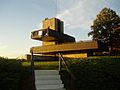
South Sugarloaf observation platform
