
Holyoke Range facts for kids
Quick facts for kids Holyoke Range |
|
|---|---|
| Metacomet Ridge | |

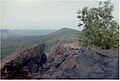
View from Bare Mountain to Mount Norwottuck
|
|
| Highest point | |
| Peak | Mount Norwottuck |
| Elevation | 1,106 ft (337 m) |
| Dimensions | |
| Length | 9.5 mi (15.3 km) east-west |
| Geography | |
| Country | United States |
| Range coordinates | 42°18′15″N 72°32′20″W / 42.30417°N 72.53889°W |
| Geology | |
| Age of rock | Triassic and Jurassic |
| Type of rock | fault-block, igneous and sedimentary |
The Holyoke Range (also called the Mount Holyoke Range) is a chain of mountains in the Connecticut River Valley in Massachusetts. It's part of a longer mountain range called the Metacomet Ridge, which stretches from Connecticut all the way to the Vermont border.
This mountain range is popular for hiking. It's special because it runs from east to west, which is unusual for mountains in this area. It also has high cliffs and beautiful views. The range is home to unique plant life and important historical places, like the Mount Holyoke Summit House and the Horse Caves.
Contents
- What's in a Name? Holyoke Range or Mount Holyoke Range?
- Exploring the Geography of the Holyoke Range
- A Look Back: History of the Holyoke Range
- Geology and Environment of the Holyoke Range
- Fun Activities: Recreation in the Holyoke Range
- Protecting the Holyoke Range: Conservation Efforts
- Images for kids
What's in a Name? Holyoke Range or Mount Holyoke Range?
You might hear these mountains called by two different names: the Holyoke Range or the Mount Holyoke Range. Both names are correct and are used by different groups and maps. For example, the state park system uses "Mount Holyoke Range," while some older maps use "Holyoke Range." Locally, people use both names.
Exploring the Geography of the Holyoke Range


The Holyoke Range is located in several towns, including South Hadley, Hadley, Granby, Amherst, and Belchertown. The mountains rise sharply from 300 feet (91 m) to 1,100 feet (335 m) above the valley floor.
The range is about 9.5 miles (15.3 km) long and 2.5 miles (4.0 km) wide at its widest point. The highest point is Mount Norwottuck, which is 1,106 feet (337 m) above sea level.
Some of the important peaks in the range, from west to east, include:
- Mount Holyoke (935 feet (285 m))
- The Seven Sisters (a series of peaks with a high point of 945 feet (288 m))
- Mount Hitchcock (1,002 feet (305 m))
- Bare Mountain (1,014 feet (309 m))
- Mount Norwottuck (1,106 feet (337 m))
- Long Mountain (920 feet (280 m))
- Harris Hill (550 feet (168 m))
A mountain called Round Mountain used to be between Bare Mountain and Norwottuck, but it was removed by quarrying. Smaller hills extend north from the range into Hadley and Amherst, like Tinker Hill and Mount Pollux.
Water from the north side of the range flows into the Fort River, then into the Connecticut River. Water from the south side flows into Bachelor Brook, also leading to the Connecticut River. All this water eventually reaches Long Island Sound.
A Look Back: History of the Holyoke Range
.jpg)
Mount Holyoke got its name from Elizur Holyoke, an early settler in the 1600s. The city of Holyoke and Mount Holyoke College were later named after the mountain.
Native Americans lived in this area for at least 10,000 years. They grew crops like corn and beans in the fertile valley. They also hunted, fished, and made tools from the rocks found in the mountains.
In the mid-1600s, European settlers arrived. Tensions grew between the Pocomtuc Native American tribe and the settlers, leading to King Philip's War in 1675. After the war, more settlers came, and much of the land was cleared for farms. The rich soil was perfect for growing tobacco.
Mountains like the Holyoke Range were often used for timber to make charcoal, which was important for the steel industry. However, by the early 1900s, farming moved west, and charcoal became less profitable. Because of this, the forests in New England grew back.
In the 1800s, people started to appreciate nature more. Artists like Thomas Cole painted beautiful landscapes of the area, including a famous painting of the Connecticut River from Mount Holyoke. This led to people seeing the mountains as a place for fun and beauty, not just for resources.
Hotels and parks were built on the mountains from the late 1800s to the early 1900s. Roads and even trolley tracks were built through the range to make it easier for people to visit.
The Mount Holyoke Summit House

In 1821, a small guest cabin was built on Mount Holyoke. This was one of the first "summit houses" in New England. Later, in 1851, it was rebuilt into a two-story hotel.
The hotel became very popular. A covered tramway (first pulled by horses, then mechanized) was built to take visitors to the summit. A railroad also connected the base of the mountain to steamboats on the Connecticut River. This made the Mount Holyoke "Prospect House" a famous tourist spot.
Other similar hotels were built on nearby mountains. In 1939, Joseph Allen Skinner, who owned the hotel, gave it to Massachusetts to become a state park. He asked that the park be named after him, and it is now J. A. Skinner State Park. After some damage, the summit house was renovated in the 1980s and now serves as a museum.
Other Interesting Historical Events
,_Amherst,_Massachusetts.jpg)
- The Horse Caves: These rock overhangs under Mount Norwottuck are thought to have been used by rebels during Shays' Rebellion in 1786.
- Edward Hitchcock: A geology professor from Amherst College, Edward Hitchcock studied the Holyoke Range in the 1800s. He even named some of its features, like Mount Norwottuck. He also famously suggested that dinosaur tracks found nearby were made by ancient birds.
- Mountain Day: Since 1838, students from Mount Holyoke College have celebrated "Mountain Day" every October. On a surprise autumn morning, classes are canceled, and students hike to the summit of Mount Holyoke.
- Plane Crash: On May 27, 1944, a B-24 plane crashed into the south side of the range during a training mission, killing all ten crewmen. A memorial plaque is on Mount Holyoke's summit.
- Underground Bunker: On the north side of Bare Mountain, there's an underground bunker. It was built during the Cold War for the United States Air Force Strategic Air Command in case of a nuclear attack. Today, it's used as a library storage facility for the Five Colleges.
- New England Trail: In 2009, the Holyoke Range became part of the New England National Scenic Trail. This trail connects many conservation efforts in the area.
The Tofu Curtain
The Holyoke Range has a fun nickname: "The Tofu Curtain." This name refers to a difference between the northern part of the region (Hampshire County) and the southern part (Hampden County).
Hampshire County, to the north, is home to several colleges and tends to be wealthier. Many businesses there sell natural products like tofu. Hampden County, to the south, includes cities like Holyoke and Springfield. This area has a more working-class population. The nickname highlights the cultural and economic differences between these two areas, with the Holyoke Range acting as a symbolic "curtain" between them.
Geology and Environment of the Holyoke Range

The Holyoke Range was formed about 200 million years ago. It's made of a type of rock called traprock, also known as basalt. Basalt is a dark rock, but the iron in it turns rusty brown when exposed to air, giving the cliffs a reddish color. This rock often breaks into cool shapes, like octagons. You can see huge piles of broken basalt rock, called talus slopes, below many of the cliffs, especially on Bare Mountain.

These basalt ridges were created by several huge lava flows. Over 20 million years, lava flowed out of cracks in the Earth as North America slowly pulled away from Europe and Africa. Between these lava flows, layers of sediment (like sand and mud) built up. Over time, these sediments turned into sedimentary rock.
Imagine a layer cake. The basalt is like the cake layers, and the sedimentary rock is like the frosting in between. Over millions of years, this "layer cake" of rock tilted upwards. Then, erosion wore away the softer sedimentary layers faster than the hard basalt. This left the steep, dramatic cliffs and ridges we see today. A great place to see this is on Mount Norwottuck. The top of Norwottuck is basalt, and just below it are the Horse Caves, where the softer sedimentary rock has worn away, creating a deep overhang.
The Holyoke Range has many different types of environments, called microclimates, which are unusual for New England.
- Dry, hot upper ridges have oak savannas, with chestnut oak trees and grasses.
- Eastern red cedar trees grow on the cliff edges.
- Cooler, damp areas in ravines have Eastern hemlock trees.
- The talus slopes are rich in nutrients and support special plants that are rare in Massachusetts.
Because of these varied environments, the traprock ridges are home to several rare plant and animal species, including the timber rattlesnake. The Holyoke Range is also an important path for raptors (birds of prey) during their yearly migration.
Fun Activities: Recreation in the Holyoke Range

You can drive a car to the summit of Mount Holyoke during certain seasons. Many miles of trails wind through the range, including the 110-mile (180 km) Metacomet-Monadnock Trail and the 47-mile (76 km) Robert Frost Trail.
The Holyoke Range is a great place for many outdoor activities:
- Picnicking
- Hiking
- Backcountry skiing
- Cross-country skiing
- Mountain biking
- Horseback riding
- Bird watching
- Hunting (in season)
- Snowshoeing
There's also an information center called "The Notch" on Massachusetts Route 116, where the towns of Granby, Amherst, and South Hadley meet.
Protecting the Holyoke Range: Conservation Efforts

Much of the Holyoke Range is protected as part of Massachusetts's J.A. Skinner State Park and Mount Holyoke Range State Park. Other parts are managed by non-profit groups or are private land.
In 2000, the Holyoke Range was studied by the National Park Service to become a new National Scenic Trail. This goal was achieved on March 30, 2009, when it became part of the New England National Scenic Trail.
Unfortunately, quarrying (removing rock from the ground) has caused the loss of a mountain called Round Mountain, which used to be between Bare Mountain and Mount Norwottuck. In the late 1990s, there was a plan to build houses on the Seven Sisters part of the range. However, several non-profit groups and local governments worked together to stop the construction and protect the ridgeline by adding it to Skinner State Park.
Many groups are working to protect the Holyoke Range and its beautiful views. These include the Kestrel Trust, The Valley Land Fund, the Berkshire Chapter of the Appalachian Mountain Club, and the Friends of the Mount Holyoke Range.
Images for kids
-
View from Bare Mountain to Mount Norwottuck
