
Granby, Massachusetts facts for kids
Quick facts for kids
Granby, Massachusetts
|
|||
|---|---|---|---|

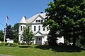
Kellogg Hall
|
|||
|
|||

Location in Hampshire County in Massachusetts
|
|||
| Country | United States | ||
| State | Massachusetts | ||
| County | Hampshire | ||
| Settled | 1727 | ||
| Incorporated | June 11, 1768 | ||
| Named for | John Manners, Marquess of Granby | ||
| Government | |||
| • Type | Open Town Meeting | ||
| Area | |||
| • Total | 28.09 sq mi (72.75 km2) | ||
| • Land | 27.83 sq mi (72.08 km2) | ||
| • Water | 0.26 sq mi (0.67 km2) | ||
| Elevation | 269 ft (82 m) | ||
| Population
(2020)
|
|||
| • Total | 6,110 | ||
| • Density | 217.52/sq mi (83.99/km2) | ||
| Time zone | UTC−5 (Eastern) | ||
| • Summer (DST) | UTC−4 (Eastern) | ||
| ZIP Code |
01033
|
||
| Area code(s) | 413 | ||
| FIPS code | 25-26535 | ||
| GNIS feature ID | 0618200 | ||


Granby is a town in Hampshire County, Massachusetts, United States. In 2020, about 6,110 people lived there. It is part of the larger Springfield area. The main village of Granby is right in the center of the town.
Contents
What's in the Name?
Granby got its name from John Manners, Marquess of Granby. He was a hero in a war called the Seven Years' War. The name 'Granby' also comes from a village in England. It means a 'farmstead' or 'settlement' in Old English.
Granby's Story: A Look at Its Past
How Granby Was Settled
Granby was once part of a bigger town called Hadley. The first settlers came to Old Hadley in 1659. They moved from Hartford and Wethersfield, Connecticut. These families left Connecticut because they had different religious beliefs.
A man named John Pynchon bought land for the new community. In 1658, he made a deal with three Norwottuck leaders. The deal set aside land for the Norwottuck people's cornfields. It also promised them rights to hunt, fish, and set up wigwams. The land was then given to the settlers.
In 1662, Pynchon made another land deal. This land is now part of Granby, South Hadley, and Belchertown. The Norwottuck family received 150 fathoms of wampum (many beads) and other items. They were also promised rights to hunt, fish, and gather wood on common lands.
Becoming Its Own Town
People started settling in Granby in 1727. In November 1727, residents asked to form a new area within Hadley. This was approved in 1732, creating Hadley's South Precinct. In 1753, it became a district.
From 1751 to 1761, there was a big disagreement. People couldn't decide where to build a new meetinghouse. Some wanted it in what is now South Hadley, others in Granby. In 1761, the west side started building a meetinghouse without permission. So, people from the east side tore it down.
In 1762, the area was split into two parts. Each part had its own meetinghouse. Because of the ongoing disagreements, the east part became the Town of Granby. This happened on June 11, 1768.
Granby in the 1900s
Granby is special because it has its own telephone service. It's called Granby Telephone & Telegraph. It has been providing service since 1903. Most towns in Massachusetts use a different phone company.
Granby's Location and Landscape

Granby covers about 72.7 square kilometers (28.1 square miles). Most of this is land, with a small amount of water. Granby is next to South Hadley to the west and Amherst to the north. To the east is Belchertown, and to the south are Ludlow and Chicopee.
Two main roads go through Granby. U.S. Route 202 runs east through town. Route 116 goes northeast towards Amherst. Granby is about 13 miles (21 km) north of Springfield. Springfield is the biggest city in western Massachusetts.
The Holyoke Range of mountains is in northern Granby. Important peaks here include Long Mountain and Mount Norwottuck. Mount Norwottuck is the highest point in town. It is about 1,106 feet (337 meters) above sea level. The Metacomet-Monadnock Trail runs along this mountain range. You can also find the Horse Caves along this trail.
Who Lives in Granby?
| Historical population | ||
|---|---|---|
| Year | Pop. | ±% |
| 1850 | 1,104 | — |
| 1860 | 907 | −17.8% |
| 1870 | 863 | −4.9% |
| 1880 | 753 | −12.7% |
| 1890 | 765 | +1.6% |
| 1900 | 761 | −0.5% |
| 1910 | 761 | +0.0% |
| 1920 | 779 | +2.4% |
| 1930 | 891 | +14.4% |
| 1940 | 1,085 | +21.8% |
| 1950 | 1,861 | +71.5% |
| 1960 | 4,221 | +126.8% |
| 1970 | 5,473 | +29.7% |
| 1980 | 5,380 | −1.7% |
| 1990 | 5,565 | +3.4% |
| 2000 | 6,132 | +10.2% |
| 2010 | 6,240 | +1.8% |
| 2020 | 6,110 | −2.1% |
| 2022* | 6,055 | −0.9% |
| * = population estimate. | ||
In 2000, there were 6,132 people living in Granby. There were 2,247 households, with 1,662 of them being families. About 34.5% of households had children under 18. Most households (62.8%) were married couples.
The people in Granby were mostly White (96.77%). Other groups included Black or African American (0.51%) and Asian (0.96%). About 1.21% of the population was Hispanic or Latino.
The average age in Granby was 38 years old. About 25.5% of the people were under 18. About 11.7% were 65 years or older. For every 100 females, there were about 96 males.
The average income for a household in Granby was $54,293. For families, it was $57,632. A small number of families (1.0%) and people (2.2%) lived below the poverty line.
Schools in Granby
Granby has one public elementary school, the East Meadow School. It serves students from kindergarten to sixth grade. Older students go to Granby Junior Senior High School. There is also a private school in Granby called MacDuffie School.
Famous People from Granby
- Charles Burchard, a politician from Wisconsin.
- George Cobb, a sports coach.
- William Montague Ferry (1796–1867), a minister and missionary. He helped start several settlements in Michigan.
- Abbie E. C. Lathrop (1868–1918), known for breeding mice and her early work in genetic research.
- Zenas Ferry Moody (1832–1917), who was the seventh governor of Oregon.
- Jesse Richards, an artist, photographer, and filmmaker.
Images for kids
-
Kellogg Hall
-
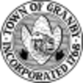
Seal of Granby, Massachusetts
-

Flag of Granby, Massachusetts
-
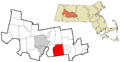
Location of Granby in Hampshire County
See also
 In Spanish: Granby (Massachusetts) para niños
