List of counties in Massachusetts facts for kids
Quick facts for kids Counties of Massachusetts |
|
|---|---|
 |
|
| Location | Commonwealth of Massachusetts |
| Number | 14 |
| Populations | 14,444 (Nantucket) – 1,623,952 (Middlesex) |
| Areas | 48 square miles (120 km2) (Nantucket) – 1,513 square miles (3,920 km2) (Worcester) |
| Government | County government |
| Subdivisions | cities, towns, villages, unincorporated communities, census designated place |
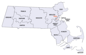
Massachusetts is a state in the USA. It has 14 areas called counties. But here's a cool fact: eight of these counties don't have their own local governments anymore! This change happened between 1997 and 2000.
Some counties in the southeast, like Barnstable and Bristol, still have their own county governments. Nantucket County is special. Its city and county governments are combined into one. Even where county governments are gone, their old borders are still used for things like courts and police. People also still think of them as geographic areas. Three counties (Hampshire, Barnstable, and Franklin) have even created new regional groups. These groups help manage things across their areas.
Contents
Why Some County Governments Were Removed
In the mid-1990s, Middlesex County had problems. Its public hospital was not managed well. This almost made the county go broke. So, in 1997, the Massachusetts government stepped in. They took over all of Middlesex County's money and debts. The government of Middlesex County officially ended on July 11, 1997.
Later that year, Franklin County decided to end its own government. The law that ended Middlesex County also planned to remove Hampden County and Worcester County on July 1, 1998. This law was changed later. It also removed Hampshire County on January 1, 1999. Then, Essex County and Suffolk County ended on July 1, 1999. Finally, Berkshire County was removed on July 1, 2000.
State law lets other counties choose to end their governments. They can also become a "regional council of governments." Hampshire and Franklin Counties have done this. The governments of Bristol, Plymouth, and Norfolk Counties are still mostly the same. Barnstable and Dukes Counties have updated their rules. This helps them work as good regional governments. Dukes County has a strong planning group called the Martha's Vineyard Commission.
Understanding District Attorneys
District Attorneys are lawyers who handle criminal cases. Their areas are set by state law. Some of these areas follow the old county lines. But often, the names and areas are different.
For example, in Essex County, criminal cases are handled by the District Attorney for the Eastern District. In Middlesex County, it's the Northern District Attorney. In Worcester County, it's the Middle District Attorney. For Dukes, Barnstable, and Nantucket counties, it's the Cape and Islands District Attorney. Franklin and Hampshire counties use the Northwestern District Attorney.
The areas for Berkshire, Bristol, Hampden, Norfolk, Plymouth, and Suffolk counties are the same as their county names. The District Attorneys for the Eastern, Middle, and Northern Districts are often called the Essex County, Worcester County, and Middlesex County District Attorneys.
Massachusetts' Past Counties
Massachusetts has had eleven other counties in its history. Most of these counties disappeared. Their land became part of New Hampshire or Maine. Both of these states were once part of Massachusetts.
The oldest counties still in Massachusetts are Essex County, Middlesex County, and Suffolk County. They were created in 1643. The original Norfolk County was also created then. But it was taken over by New Hampshire. It is not related to the modern Norfolk County.
When these counties were made, they were part of the Massachusetts Bay Colony. This colony was separate from the Plymouth Colony until 1691. Hampden County, created in 1812, is the newest county still in Massachusetts. Most Massachusetts counties are named after places in England. This shows the state's history as a colony.
What is a Shire Town?
The term shire town is a legal word in Massachusetts. It means a town that has a county court and government offices. A county can have more than one shire town. The more common term used by the Massachusetts government is county seat.
About FIPS Codes
The Federal Information Processing Standard (FIPS) code is a special number. The United States government uses it to identify counties. Each FIPS code has five digits. For Massachusetts, the codes start with 25. Then, there are three digits for the county code. The FIPS code for each county in the table below links to census data for that county.
List of Current Counties
| County |
FIPS code | County seat | Est. | Origin | Etymology | Population | Area | Map |
|---|---|---|---|---|---|---|---|---|
| Barnstable County | 001 | Barnstable | 1685 | One of three original counties created in the Plymouth Colony | Named after its county seat of Barnstable, which is named after the English town of Barnstaple | 231,735 | 396 sq mi (1,026 km2) |
 |
| Berkshire County | 003 | Pittsfield | 1761 | Formed from part of Hampshire County. Its government ended in 2000. | Named for the English county of Berkshire | 126,818 | 931 sq mi (2,411 km2) |
 |
| Bristol County | 005 | Taunton | 1685 | One of three original counties created in the Plymouth Colony | Named for its first county seat of Bristol, Massachusetts. This town was named for the English port city of Bristol. When the Town of Bristol joined Rhode Island, the county name stayed. | 581,841 | 556 sq mi (1,440 km2) |
 |
| Dukes County | 007 | Edgartown | 1695 | Formed from Martha's Vineyard and the Elizabeth Islands. These were part of Dukes County, New York, until Massachusetts gained them in 1691. | Formerly part of Dukes County, New York until 1691. The land was once owned by the Duke of York. | 20,819 | 104 sq mi (269 km2) |
 |
| Essex County | 009 | Salem, Lawrence |
1643 | One of four original counties created in the Massachusetts Bay Colony. Its government ended in 1999. | Named for the English county of Essex | 810,089 | 498 sq mi (1,290 km2) |
 |
| Franklin County | 011 | Greenfield | 1811 | Formed from part of Hampshire County. Its government ended in 1997. | Named for Benjamin Franklin (1706–1790), a famous early American scientist, diplomat, and politician. | 70,836 | 702 sq mi (1,818 km2) |
 |
| Hampden County | 013 | Springfield | 1812 | Formed from part of Hampshire County. Its government ended in 1998. | Named for John Hampden (1595—1643), a famous 17th-century English politician. | 460,291 | 618 sq mi (1,601 km2) |
 |
| Hampshire County | 015 | Northampton | 1662 | Formed from unorganized land in the western part of the Massachusetts Bay Colony. Its government ended in 1999. | Named for the English county of Hampshire | 162,502 | 529 sq mi (1,370 km2) |
 |
| Middlesex County | 017 | Lowell, Cambridge |
1643 | One of four original counties created in the Massachusetts Bay Colony. Its government ended in 1997. | Named for the English county of Middlesex | 1,623,952 | 824 sq mi (2,134 km2) |
 |
| Nantucket County | 019 | Nantucket | 1695 | Formed from Nantucket Island. This island was part of Dukes County, New York until Massachusetts gained it in 1691. | Named for the Town of Nantucket. The name comes from a Wampanoag word meaning "place of peace." | 14,444 | 48 sq mi (124 km2) |
 |
| Norfolk County | 021 | Dedham | 1793 | Formed from part of Suffolk County. | Named for the English county of Norfolk | 727,473 | 400 sq mi (1,036 km2) |
 |
| Plymouth County | 023 | Brockton, Plymouth |
1685 | One of three original counties created in the Plymouth Colony. | Named for its seat of Plymouth. This town was named for the English port city of Plymouth. | 535,308 | 661 sq mi (1,712 km2) |
 |
| Suffolk County | 025 | Boston | 1643 | One of four original counties created in the Massachusetts Bay Colony. Its government ended in 1999. | Named for the English county of Suffolk | 768,425 | 58 sq mi (150 km2) |
 |
| Worcester County | 027 | Worcester | 1731 | Formed from parts of Hampshire County, Middlesex County, and Suffolk County. Its government ended in 1998. | Named for its county seat of Worcester. This town was named for the English city of Worcester and the English Civil War Battle of Worcester in 1651. | 866,866 | 1,513 sq mi (3,919 km2) |
 |
Counties That No Longer Exist
| County |
Created |
Abolished |
What Happened |
|---|---|---|---|
| Cumberland County | 1760 | 1820 | Became part of Maine |
| Devonshire County | 1674 | 1675 | Ended and then became part of Maine |
| Hancock County | 1789 | 1820 | Became part of Maine |
| Kennebec County | 1799 | 1820 | Became part of Maine |
| Lincoln County | 1760 | 1820 | Became part of Maine |
| Norfolk County | 1643 | 1679 | Ended – most of its land became part of New Hampshire. Towns left in Massachusetts became part of Essex County. This was one of four original counties created in the Massachusetts Bay Colony. |
| Oxford County | 1805 | 1820 | Became part of Maine |
| Penobscot County | 1816 | 1820 | Became part of Maine |
| Somerset County | 1809 | 1820 | Became part of Maine |
| Washington County | 1789 | 1820 | Became part of Maine |
| York County | 1652 | 1820 | Became part of Maine – York County was ended twice before this, from 1664 to 1668 and from 1680 to 1691. |
See Also
 In Spanish: Anexo:Condados de Massachusetts para niños
- Administrative divisions of Massachusetts
- Government of Massachusetts – section on local government
- List of former United States counties
 | Jackie Robinson |
 | Jack Johnson |
 | Althea Gibson |
 | Arthur Ashe |
 | Muhammad Ali |


