Kennebec County, Maine facts for kids
Quick facts for kids
Kennebec County
|
||
|---|---|---|

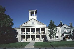
Kennebec County Courthouse
|
||
|
||

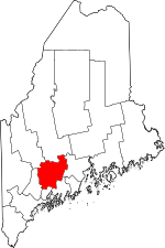
Location within the U.S. state of Maine
|
||
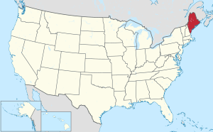
 Maine's location within the U.S. |
||
| Country | ||
| State | ||
| Founded | 1799 | |
| Named for | Kennebec River | |
| Seat | Augusta | |
| Largest city | Augusta | |
| Area | ||
| • Total | 951 sq mi (2,460 km2) | |
| • Land | 868 sq mi (2,250 km2) | |
| • Water | 84 sq mi (220 km2) 8.8%% | |
| Population
(2020)
|
||
| • Total | 123,642 | |
| • Density | 130.01/sq mi (50.198/km2) | |
| Time zone | UTC−5 (Eastern) | |
| • Summer (DST) | UTC−4 (EDT) | |
| Congressional districts | 1st, 2nd | |
Kennebec County is a place in the middle of Maine, a state in the United States. In 2020, about 123,642 people lived here. Its main city is Augusta, which is also the capital city of Maine.
Kennebec County was created on February 20, 1799. It was formed from parts of other counties called Cumberland and Lincoln. The name Kennebec comes from the Abenaki language. It means "large body of still water" or "large bay."
This county is part of a special area called the Augusta–Waterville Micropolitan Area. In 2010, the middle point of Maine's population was right here in Augusta.
Contents
Geography of Kennebec County
Kennebec County covers about 951 square miles. Most of this area, about 868 square miles, is land. The rest, about 84 square miles, is water. This means about 8.8% of the county is covered by water.
The Kennebec River flows almost completely through the county. It also forms parts of the county's northern and southern borders. Many lakes and ponds are found here. The Kennebec Highlands are in the northwest part of the county.
Neighboring Counties
Kennebec County shares borders with several other counties:
- Somerset County to the north
- Waldo County to the east
- Sagadahoc County to the south
- Lincoln County to the south
- Androscoggin County to the southwest
- Franklin County to the northwest
Main Roads and Highways
Many important roads and highways pass through Kennebec County. These roads help people travel and transport goods. Some of the major routes include:
 I-95
I-95 I-295
I-295 US 201
 US 202
 SR 8
SR 8 SR 9
SR 9 SR 11
SR 11 SR 17
SR 17 SR 23
SR 23 SR 27
SR 27 SR 32
SR 32 SR 41
SR 41 SR 100
 SR 104
 SR 105
 SR 126
 SR 132
 SR 133
 SR 135
 SR 139
 SR 194
 SR 197
 SR 226
People of Kennebec County
In 2010, about 122,151 people lived in Kennebec County. There were over 51,000 households. The county had about 140 people per square mile. Many different backgrounds make up the population. Some of the main ancestries include English, Irish, German, and French Canadian.
The average income for a household in the county was about $45,973. For families, it was around $56,853. About 12.5% of the people in the county lived below the poverty line.
Augusta–Waterville Micropolitan Area
Kennebec County is known as the Augusta–Waterville, ME Micropolitan Statistical Area. This is a special way the government groups areas with a city and its nearby communities. It helps them understand population and economy.
As of 2010, this micropolitan area was the most populated in Maine. It was also the only one in the state. In July 2022, it ranked as the 14th most populated micropolitan area in the United States. Its population was about 125,540 people.
Economy and Jobs
For a long time, Kennebec County's economy was based on industry. Many paper and textile mills were built along the Kennebec River. These mills produced a lot of goods.
Today, the average income for a household is around $36,498. The unemployment rate, which is the number of people looking for jobs, is about 4.2%.
Education in Kennebec County
Kennebec County has several colleges and many school districts. This offers many learning opportunities for students.
Colleges and Universities
There are three colleges in the county:
- Colby College in Waterville
- Thomas College in Waterville
- University of Maine at Augusta in Augusta
School Districts
The county has 19 school districts, including some that have joined together. For example, in China, Maine, there isn't a public high school. However, the town pays for students to attend a private school called Erskine Academy if they choose. Students from Vassalboro can pick from four different school districts. Many towns also have their own local public high schools.
Here are some of the K-12 school districts:
- Augusta School District
- Fayette School District
- Vassalboro School District
- Waterville School District
- Winslow School District
- Winthrop School District
- Regional School Unit 02
- Regional School Unit 04
- Regional School Unit 18
- Regional School Unit 12
- Regional School Unit 38
- School Administrative District 09
- School Administrative District 11
- School Administrative District 49
- Kennebec Unorganized Territory
Cities and Towns
Kennebec County is made up of several cities and many towns. Each community has its own unique character.
Cities
- Augusta (This is the county seat, meaning it's the main administrative city.)
- Gardiner
- Hallowell
- Waterville
Towns
Unorganized Territory
- Unity
Census-Designated Places (CDPs)
These are areas that the U.S. Census Bureau defines for statistical purposes. They are like towns but don't have their own local government.
Other Villages
These are smaller, unincorporated communities within the towns.
- China Village
- East Vassalboro
- East Winthrop
- Libby Hill
- North Monmouth
- North Vassalboro
- South China
See also
 In Spanish: Condado de Kennebec para niños
 | Sharif Bey |
 | Hale Woodruff |
 | Richmond Barthé |
 | Purvis Young |


