Rome, Maine facts for kids
Quick facts for kids
Rome, Maine
|
|
|---|---|

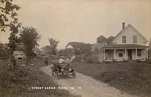
Street scene, c. 1916
|
|

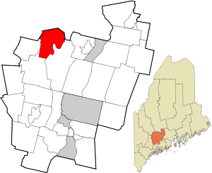
Location in Kennebec County and the state of Maine.
|
|
| Country | United States |
| State | Maine |
| County | Kennebec |
| Incorporated | 1804 |
| Villages |
|
| Area | |
| • Total | 31.72 sq mi (82.15 km2) |
| • Land | 25.41 sq mi (65.81 km2) |
| • Water | 6.31 sq mi (16.34 km2) |
| Elevation | 249 ft (76 m) |
| Population
(2020)
|
|
| • Total | 1,148 |
| • Density | 45/sq mi (17.4/km2) |
| Time zone | UTC-5 (Eastern (EST)) |
| • Summer (DST) | UTC-4 (EDT) |
| ZIP Code |
04963
|
| Area code(s) | 207 |
| FIPS code | 23-63835 |
| GNIS feature ID | 0582700 |
Rome is a small town located in Kennebec County, Maine, in the United States. In 2020, about 1,148 people lived there. Rome is part of the popular Belgrade Lakes area, which is known for its beautiful lakes and outdoor activities. It is also included in the larger Augusta, Maine, area.
Contents
History of Rome, Maine
Rome was first settled around 1780. Richard Furbush, from Lebanon, was one of the first people to live there. The town was officially created on March 7, 1804. It was named after the famous city of Rome in Italy.
Even though the land was a bit hilly, it was great for grazing animals. By 1839, Rome had a population of 1,074 people. It was known as a "beautiful farming town" with a "pleasant village." Farmers grew a lot of wheat, harvesting over 4,000 bushels in 1837.
The many ponds in Rome were full of fish like trout, perch, and pickerel. By 1859, the town had a sawmill, a gristmill (for grinding grain), and a shingle mill. However, agriculture (farming) was still the most important job for most people. By 1870, Rome had two post offices, one in Rome and one in Belgrade Mills.
Geography of Rome, Maine
Rome covers a total area of about 31.72 square miles (82.15 square kilometers). Most of this area is land, about 25.41 square miles (65.81 square kilometers). The rest, about 6.31 square miles (16.34 square kilometers), is water. The town includes the northern parts of two large ponds, Long Pond and Great Pond.
Several state roads help people travel through Rome. These include Route 8, Route 27, Route 137, and Route 225. Rome shares its borders with several other towns. These are Vienna to the west, Mount Vernon to the west and south, Belgrade to the south and east, a part of Smithfield to the northeast, Mercer to the north, and New Sharon to the northwest.
Population and People
| Historical population | |||
|---|---|---|---|
| Census | Pop. | %± | |
| 1810 | 585 | — | |
| 1820 | 533 | −8.9% | |
| 1830 | 883 | 65.7% | |
| 1840 | 987 | 11.8% | |
| 1850 | 830 | −15.9% | |
| 1860 | 864 | 4.1% | |
| 1870 | 725 | −16.1% | |
| 1880 | 606 | −16.4% | |
| 1890 | 500 | −17.5% | |
| 1900 | 420 | −16.0% | |
| 1910 | 440 | 4.8% | |
| 1920 | 436 | −0.9% | |
| 1930 | 398 | −8.7% | |
| 1940 | 418 | 5.0% | |
| 1950 | 420 | 0.5% | |
| 1960 | 367 | −12.6% | |
| 1970 | 362 | −1.4% | |
| 1980 | 627 | 73.2% | |
| 1990 | 758 | 20.9% | |
| 2000 | 980 | 29.3% | |
| 2010 | 1,010 | 3.1% | |
| 2020 | 1,148 | 13.7% | |
| U.S. Decennial Census | |||
How Many People Live Here?
According to the census from 2010, there were 1,010 people living in Rome. These people lived in 439 households, and 299 of these were families. The town had about 39.7 people per square mile. There were also 1,038 housing units, which are places where people can live.
Many different types of households make up the town. About 25% of households had children under 18 living with them. Most households, about 53%, were married couples living together. The average household had 2.30 people, and the average family had 2.67 people.
The average age of people in Rome was 46.2 years old. About 19% of residents were under 18 years old. About 14% were 65 years old or older. The town had slightly more males (51.5%) than females (48.5%).
See also
 In Spanish: Rome (Maine) para niños
 | Anna J. Cooper |
 | Mary McLeod Bethune |
 | Lillie Mae Bradford |

