Mount Vernon, Maine facts for kids
Quick facts for kids
Mount Vernon, Maine
|
|
|---|---|
| Motto(s):
"Life in a small town USA"
|
|

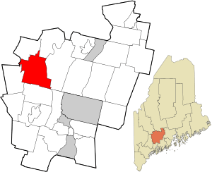
Location in Kennebec County and the state of Maine
|
|
| Country | United States |
| State | Maine |
| County | Kennebec |
| Villages | Mount Vernon Dunns Corner West Mount Vernon |
| Area | |
| • Total | 43.42 sq mi (112.46 km2) |
| • Land | 37.90 sq mi (98.16 km2) |
| • Water | 5.52 sq mi (14.30 km2) |
| Elevation | 518 ft (158 m) |
| Population
(2020)
|
|
| • Total | 1,721 |
| • Density | 45/sq mi (17.5/km2) |
| Time zone | UTC-5 (Eastern (EST)) |
| • Summer (DST) | UTC-4 (EDT) |
| ZIP code |
04352
|
| Area code(s) | 207 |
| FIPS code | 23-47770 |
| GNIS feature ID | 0582612 |
| Website | Town of Mount Vernon, Maine |
Mount Vernon is a small town in Kennebec County, Maine, United States. In 2020, about 1,721 people lived there. Mount Vernon is part of the larger Augusta area. It's a popular spot for outdoor fun in central Maine. The northern part of the town is in the Belgrade Lakes Region. The southern part is in the Winthrop Lakes Region.
Contents
History of Mount Vernon
Mount Vernon became an official town on June 28, 1792. It was named after George Washington's famous home in Virginia.
Geography of Mount Vernon
Mount Vernon covers a total area of about 43.42 square miles (112.46 square kilometers). Most of this area, about 37.90 square miles (98.16 square kilometers), is land. The rest, about 5.52 square miles (14.30 square kilometers), is water.
People of Mount Vernon
Population Numbers
The population of Mount Vernon has changed over the years. Here's how many people have lived there during different census counts:
| Historical population | |||
|---|---|---|---|
| Census | Pop. | %± | |
| 1800 | 740 | — | |
| 1810 | 1,098 | 48.4% | |
| 1820 | 1,293 | 17.8% | |
| 1830 | 1,439 | 11.3% | |
| 1840 | 1,475 | 2.5% | |
| 1850 | 1,479 | 0.3% | |
| 1860 | 1,464 | −1.0% | |
| 1870 | 1,252 | −14.5% | |
| 1880 | 1,170 | −6.5% | |
| 1890 | 940 | −19.7% | |
| 1900 | 906 | −3.6% | |
| 1910 | 898 | −0.9% | |
| 1920 | 745 | −17.0% | |
| 1930 | 755 | 1.3% | |
| 1940 | 653 | −13.5% | |
| 1950 | 653 | 0.0% | |
| 1960 | 596 | −8.7% | |
| 1970 | 680 | 14.1% | |
| 1980 | 1,021 | 50.1% | |
| 1990 | 1,362 | 33.4% | |
| 2000 | 1,524 | 11.9% | |
| 2010 | 1,640 | 7.6% | |
| 2020 | 1,721 | 4.9% | |
| U.S. Decennial Census | |||
A Look at the Community
In 2010, there were 1,640 people living in Mount Vernon. These people lived in 693 homes. Most residents were White. A small number of people were of other races.
About 27% of homes had children under 18 living there. More than half of the homes were married couples living together. The average age of people in Mount Vernon was about 45.7 years old.
Education in Mount Vernon
Mount Vernon is part of the Maranacook Central School District. This district is known as Regional School Unit 38. Jay Charette is the Superintendent of Schools for the district.
The schools in this system include:
- Manchester Elementary School
- Mount Vernon Elementary School
- Readfield Elementary School
- Wayne Elementary School
- Maranacook Community Middle School
- Maranacook Community High School
Famous People from Mount Vernon
Some notable people have come from Mount Vernon:
- Joseph W. Allen: A politician who served in the state government.
- Joseph Payne: A talented musician.
- John H. Rice: A U.S. congressman.
- Moses Sherburne: A politician and a judge on the Minnesota Supreme Court.
- John L. Stevens: A U.S. diplomat and one of the people who helped start the Republican Party.
See also
 In Spanish: Mount Vernon (Maine) para niños
 | Mary Eliza Mahoney |
 | Susie King Taylor |
 | Ida Gray |
 | Eliza Ann Grier |

