Franklin County, Maine facts for kids
Quick facts for kids
Franklin County
|
|
|---|---|

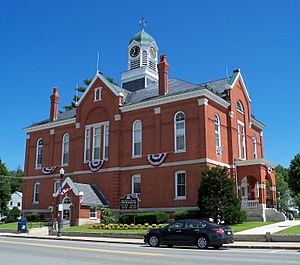
Franklin County Courthouse
|
|

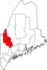
Location within the U.S. state of Maine
|
|
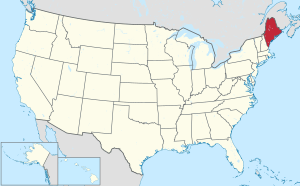
 Maine's location within the U.S. |
|
| Country | |
| State | |
| Founded | May 9, 1838 |
| Named for | Benjamin Franklin |
| Seat | Farmington |
| Largest town | Farmington |
| Area | |
| • Total | 1,743 sq mi (4,510 km2) |
| • Land | 1,697 sq mi (4,400 km2) |
| • Water | 47 sq mi (120 km2) 2.7%% |
| Population
(2020)
|
|
| • Total | 29,456 |
| • Estimate
(2023)
|
30,828 |
| • Density | 16.900/sq mi (6.5250/km2) |
| Time zone | UTC−5 (Eastern) |
| • Summer (DST) | UTC−4 (EDT) |
| Congressional district | 2nd |
Franklin County is a place in the state of Maine, United States. It's like a big district or region. In 2020, about 29,456 people lived here. This makes it the second-smallest county in Maine by population. The main town and center of the county is Farmington. Franklin County was created on May 9, 1838. It was named after the famous American inventor and statesman, Benjamin Franklin.
Contents
History of Franklin County
Franklin County was officially formed on May 9, 1838. It was made from parts of three other counties: Kennebec, Oxford, and Somerset. Over the next 14 years, some small changes were made to its borders.
Geography and Nature
Franklin County covers a total area of about 1,743 square miles. Most of this area, about 1,697 square miles, is land. The rest, about 47 square miles, is water, which is about 2.7% of the total area.
The county is home to parts of the Appalachian Mountains. You can find several beautiful lakes and ponds here. These include Rangely Lake, the Chain of Ponds, and part of Mooselookmegantic Lake. The highest point in the county is Sugarloaf Mountain. This mountain is a popular ski spot in Carrabassett Valley. It stands tall at 4,237 feet.
Neighboring Areas
Franklin County shares its borders with several other counties and a region in Canada:
- Somerset County – to the northeast
- Kennebec County – to the southeast
- Androscoggin County – to the south
- Oxford County – to the southwest
- Le Granit Regional County Municipality, Quebec – to the northwest (in Canada)
Main Roads
Several important roads run through Franklin County, connecting its towns and communities:
 US 2
US 2 SR 4
SR 4 SR 16
SR 16 SR 17
SR 17 SR 27
SR 27 SR 133
 SR 142
 SR 156
 SR 236
People of Franklin County
| Historical population | |||
|---|---|---|---|
| Census | Pop. | %± | |
| 1840 | 20,801 | — | |
| 1850 | 20,027 | −3.7% | |
| 1860 | 20,403 | 1.9% | |
| 1870 | 18,807 | −7.8% | |
| 1880 | 18,180 | −3.3% | |
| 1890 | 17,053 | −6.2% | |
| 1900 | 18,444 | 8.2% | |
| 1910 | 19,119 | 3.7% | |
| 1920 | 19,825 | 3.7% | |
| 1930 | 19,941 | 0.6% | |
| 1940 | 19,896 | −0.2% | |
| 1950 | 20,682 | 4.0% | |
| 1960 | 20,069 | −3.0% | |
| 1970 | 22,444 | 11.8% | |
| 1980 | 27,098 | 20.7% | |
| 1990 | 29,008 | 7.0% | |
| 2000 | 29,467 | 1.6% | |
| 2010 | 30,768 | 4.4% | |
| 2020 | 29,456 | −4.3% | |
| 2023 (est.) | 30,828 | 0.2% | |
| U.S. Decennial Census 1790–1960 1900–1990 1990–2000 2010–2016 |
|||
In 2015, many people in Franklin County said their families came from different parts of the world. The largest groups reported were English, French or French Canadian, and Irish backgrounds.
According to the 2010 United States Census, there were 30,768 people living in the county. Most people were white (97.3%). The average age of people living in Franklin County was 43.4 years old.
Law Enforcement and Safety
In Franklin County, some towns have their own police departments. These include Carrabassett Valley, Farmington, Jay, Rangeley, and Wilton. For all other communities, the Franklin County Sheriff's Department handles police patrols and emergency calls. The current sheriff is Scott Nichols.
For several years, there was a discussion about the Franklin County Jail. In 2008, a law was passed that changed how county jails operated. This meant the Franklin County jail could only hold people for up to 72 hours. If someone needed to be held longer, they had to be moved to another jail, often far away. This caused problems and extra costs.
After much discussion and effort from local officials and citizens, the Franklin County jail was allowed to return to full service in 2015. This meant it could hold inmates for longer periods, making law enforcement more efficient in the county.
Communities in Franklin County

Franklin County is made up of several towns, plantations, and other areas.
Towns
Plantations
- Coplin Plantation
- Dallas Plantation
- Rangeley Plantation
- Sandy River Plantation
Census-designated places
These are areas identified by the census bureau for statistical purposes.
- Chisholm
- Farmington
- Kingfield
- Rangeley
- Wilton
Unorganized territories
These are areas that do not have their own local government.
Unincorporated communities
These are smaller communities within the county that are not officially incorporated as towns or cities.
- Dryden
- East Dixfield
- East Wilton
- Farmington Falls
- Freeman
- Macy
- Madrid
- Mooselookmeguntic
- North Jay
- Oquossoc
See also
 In Spanish: Condado de Franklin (Maine) para niños
 | Madam C. J. Walker |
 | Janet Emerson Bashen |
 | Annie Turnbo Malone |
 | Maggie L. Walker |

