
Strong, Maine facts for kids
Quick facts for kids
Strong, Maine
|
||
|---|---|---|
 |
||
|
||
| Motto(s):
Toothpick Capital of the World
|
||

Strong, Maine
Location in Maine
|
||
| Country | United States | |
| State | Maine | |
| County | Franklin | |
| Incorporated | 1801 | |
| Communities |
|
|
| Area | ||
| • Total | 28.94 sq mi (74.95 km2) | |
| • Land | 28.35 sq mi (73.43 km2) | |
| • Water | 0.59 sq mi (1.53 km2) | |
| Elevation | 741 ft (226 m) | |
| Population
(2020)
|
||
| • Total | 1,122 | |
| • Density | 40/sq mi (15.3/km2) | |
| Time zone | UTC-5 (Eastern (EST)) | |
| • Summer (DST) | UTC-4 (EDT) | |
| ZIP code |
04983
|
|
| Area code(s) | 207 | |
| FIPS code | 23-74825 | |
| GNIS feature ID | 0582753 | |
Strong is a small town located in Franklin County, Maine, in the United States. In 2020, about 1,122 people lived there. Strong is famous for its yearly Sandy River Festival.
Contents
History of Strong, Maine

The area where Strong is now was first called Township No. 3. It was also known as Middletown and Readstown. The first settlers arrived in 1784. One of them was William Read from Nobleboro.
How Strong Got Its Name
The town was officially created on January 31, 1801. It was named after Caleb Strong. He was one of the Founding Fathers and a governor of Massachusetts. The Maine Republican Party was started here on August 7, 1854.
Early Industries and Farming
Strong is located on a hilly area next to a large bend in the Sandy River. This made the soil very good for farming. Farmers grew crops like hay, wheat, corn, oats, and potatoes.
The northeast part of the Sandy River provided water power for mills. This helped Strong become a successful town. By 1859, the town had a population of 1,008 people. It had many businesses, including:
- Sawmills (for cutting wood)
- A gristmill (for grinding grain)
- A fulling mill (for making cloth thicker)
- A carding machine (for preparing wool)
- A starch factory
- A tannery (for making leather)
Growth and New Businesses
In 1879, a special narrow gauge train track called the Sandy River Railroad connected Strong to nearby towns like Farmington and Phillips. This helped businesses grow even more.
By 1886, Strong had many different industries:
- A boot and shoe factory
- Machine shops
- Maine's very first cheese factory
- A company that made clothespins
- A factory that made cane seats for chairs
- An excelsior factory (which made wood shavings)
Strong was known as "one of the prettiest villages in the county."
The Toothpick Capital
Strong earned the nickname "Toothpick Capital of the World." This was because of the Strong Wood Products Incorporated plant. This factory used to make an amazing 20 million toothpicks every single day!
-
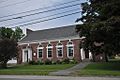
Forster Memorial Hall (town offices and library)
-

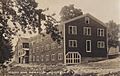
Sawmill c. 1870s
-

Sweatland Flat
-
Wood Turning Co. c. 1920


Geography and Location
According to the United States Census Bureau, Strong covers about 28.94 square miles (74.95 square kilometers). Most of this area, about 28.35 square miles (73.43 square kilometers), is land. The rest, about 0.59 square miles (1.53 square kilometers), is water.
Strong is located near a bend in the Sandy River. This river flows into the larger Kennebec River.
Neighboring Towns
Strong shares its borders with several other towns:
- To the east: New Vineyard
- To the south: Farmington
- To the west: Temple and Avon
- To the north: Freeman Township
Roads in Strong
Several state roads pass through Strong. These include Route 4, Route 145, Route 149, and Route 234. These roads help connect Strong to other places in Maine.
Population and People
| Historical population | |||
|---|---|---|---|
| Census | Pop. | %± | |
| 1810 | 424 | — | |
| 1820 | 862 | 103.3% | |
| 1830 | 985 | 14.3% | |
| 1840 | 1,109 | 12.6% | |
| 1850 | 1,008 | −9.1% | |
| 1860 | 754 | −25.2% | |
| 1870 | 634 | −15.9% | |
| 1880 | 596 | −6.0% | |
| 1890 | 627 | 5.2% | |
| 1900 | 637 | 1.6% | |
| 1910 | 720 | 13.0% | |
| 1920 | 779 | 8.2% | |
| 1930 | 878 | 12.7% | |
| 1940 | 1,007 | 14.7% | |
| 1950 | 1,036 | 2.9% | |
| 1960 | 976 | −5.8% | |
| 1970 | 1,132 | 16.0% | |
| 1980 | 1,506 | 33.0% | |
| 1990 | 1,217 | −19.2% | |
| 2000 | 1,259 | 3.5% | |
| 2010 | 1,213 | −3.7% | |
| 2020 | 1,122 | −7.5% | |
| U.S. Decennial Census | |||
Understanding the 2010 Census
The census is a count of all the people living in an area. In 2010, there were 1,213 people living in Strong. These people lived in 496 households, and 339 of these were families.
Most people in Strong were White (97.1%). A small number of people were African American, Native American, or Asian. Some people were from two or more races. About 1.2% of the population was Hispanic or Latino.
The average age in Strong was about 41.5 years old.
- About 22.5% of residents were under 18.
- About 15.4% were 65 or older.
- The town had slightly more males (51.2%) than females (48.8%).
Notable People from Strong
Many interesting people have come from Strong, Maine. Here are a few:
- Elizabeth Akers Allen: A talented author, journalist, and poet.
- Ben C. Eastman: He served as a US congressman for his state.
- John A. Eastman: He was a Wisconsin state senator.
- Julia Harris May (1833–1912): A poet, teacher, and founder of schools.
- Nathaniel W. Milliken: He was a Wisconsin state assemblyman.
- James Porter (1847–1876): A military officer who was part of Custer's Last Stand.
See also
 In Spanish: Strong (Maine) para niños
