
Kennebec River facts for kids
Quick facts for kids Kennebec River |
|
|---|---|

Wyman Lake on the Kennebec River in Somerset County, Maine
|
|
| Country | United States |
| Physical characteristics | |
| Main source | Moosehead Lake 1,024 feet (312 m) |
| River mouth | Gulf of Maine, North Atlantic Ocean |
| Length | 170 miles (270 km) |
| Basin features | |
| Basin size | 5,869 sq mi (15,200 km2) |

The Kennebec River is a long river in the state of Maine, United States. It stretches about 170 miles (270 km) from its source to the ocean.
The river begins in Moosehead Lake in west-central Maine. Its East and West Outlets meet at Indian Pond. From there, the river flows south. The Harris Station Dam, Maine's largest hydroelectric dam, is built near this meeting point. The Dead River joins the Kennebec at a place called The Forks.
The Kennebec River continues south, passing through cities like Madison, Skowhegan, Waterville, and Augusta, the state capital. Near Richmond, it flows into Merrymeeting Bay. This bay is a large freshwater area where the Androscoggin River and five smaller rivers also meet.
The Kennebec then flows past Bath, a city famous for shipbuilding. It finally empties into the Gulf of Maine in the Atlantic Ocean. The lower part of the Kennebec River has no rapids. This means that ocean tides and saltwater fish, like the endangered Atlantic sturgeon, can travel far upstream, even past Waterville. Important rivers that flow into the Kennebec include the Carrabassett River, Sandy River, and Sebasticook River. Parts of the East Coast Greenway, a path for walking and biking, follow the Kennebec.
Contents
What's in a Name?
The name "Kennebec" comes from the Eastern Abenaki word /kínipekʷ/. This word means "large body of still water" or "large bay."
History of the Kennebec River
Early Exploration and Settlements
Champlain_Samuel_btv1b2000019z.jpg)
In 1605, a French explorer named Samuel de Champlain explored the coast of what is now Maine. He mapped the land and rivers, including the Kennebec, as far as present-day Bath. In the 1600s, the Abenaki people had a village called Norridgewock along the Kennebec River.
The English also started a settlement called the Popham Colony on the Kennebec in 1607. The settlers there built the Virginia of Sagadahoc. This was the first oceangoing ship built in the New World by English shipbuilders. Later, an English trading post called Cushnoc was set up on the Kennebec in 1628.
Shipbuilding on the Kennebec
Cities like Bath grew along the Kennebec River. Skilled workers built many wooden and steel ships there. Bath became known as the "City of Ships." The Wyoming, one of the largest wooden schooners ever built, was constructed in Bath.
After the War of 1812, trade grew, and more ships were needed. Many of these ships were built in Bath. In 1854, there were at least nineteen major companies building ships in the city. Over time, shipbuilding in the U.S. slowed down as jobs moved to other countries. Today, the only shipyard left in Bath is the Bath Iron Works. It is owned by General Dynamics and still builds warships for the United States Navy. A ship named USCGC Kennebec was named after this river.
River Travel and Trade
For a long time, rivers were the easiest way to travel. The Kennebec River was an important path for trade into central Maine from the Atlantic coast. Ocean ships could travel upstream all the way to Augusta. Many towns and cities like Bath, Gardiner, Hallowell, and Augusta grew along this important travel route.
Further upstream, the river was used by the timber industry. Workers would float wooden logs and pulpwood from forests down to sawmills and paper mills. These mills used the river's water power to operate. Towns like Waterville, Winslow, Skowhegan, and Madison were important for the lumber trade. Later, railroads and roads were built along the river, following the flat land.
Conflicts and the Kennebec
In the early 1700s, there were conflicts between English settlers and the Abenaki people along the Kennebec. The Abenaki resisted the English moving onto their lands. This period is sometimes called Father Rale's War (1722–1725). In August 1724, a group of English soldiers attacked the Abenaki village at Norridgewock. Many Abenaki people were killed, including women and children. Some survivors moved further up the Kennebec or sought safety with other Native American groups.
During the American Revolutionary War in 1775, about 1,110 American soldiers followed the Kennebec River route. They were part of Benedict Arnold's expedition to Quebec.
The Ice Industry
In 1814, a man named Frederic Tudor started selling ice in the West Indies and the southern United States. In 1826, Rufus Page built the first large ice house near Gardiner. Farmers and others would cut ice from the river in winter. They stored the huge blocks in ice houses until spring. Then, the ice, packed in sawdust, was loaded onto ships and sent south.
The Great Flood of 1987
On April 1, 1987, a lot of melting snow and heavy rain caused the Kennebec River to flood. The river rose more than 21 feet (6.4 meters) above its normal flood level. This flood caused about $100 million in damage. It flooded over 2,100 homes and destroyed 215 others. Even today, you can still see signs of this flood in the towns along the river.
Whitewater Rafting Fun
In 1976, Suzanne and Wayne Hockmeyer started the first whitewater rafting trips on the Kennebec. They explored the Kennebec gorge, just below the Harris Station Dam.
Today, many rafting companies offer trips on the river from May through October. Four times each rafting season, the company that owns the dam releases a lot of water from the Harris Station Dam. These "Turbine Tests" create the biggest whitewater rapids in Maine, making for exciting rafting!
Natural Resources
Before factories and dams were built, the Kennebec River was home to many anadromous fish. These are fish like the Atlantic salmon that live in the ocean but swim upstream to lay their eggs. Building dams for hydroelectric power reduced the number of these fish.
In recent years, removing some dams on the river has been a big topic. The removal of the Edwards Dam in 1999 helped more anadromous fish return to the river.
Dams on the Kennebec
Dams are structures built across a river to control its flow, often to create electricity. The Kennebec River has several hydroelectric power stations. These dams use the river's water power to generate electricity.
Edwards Dam Removal
The Edwards Dam was built across the Kennebec River in 1837. It was made of timber and concrete, stretching 917 feet (280 m) across the river and standing 25 feet (7.6 m) high. The dam created a reservoir that stretched 17 miles (27 km) upstream.
In 1999, the dam was removed. The government decided that the benefits for the environment and fish were more important than the electricity the dam produced.
After the dam was removed, the river began to heal itself. At first, the riverbanks looked bare and the water was muddy. But soon, the ecosystem started to recover. For example, striped bass returned and helped control the population of smallmouth bass. Also, more birds of prey like ospreys, bald eagles, herons, cormorants, and kingfishers were seen.
People also benefited from the dam removal. The return of rapids and native fish species opened up new activities. These include canoeing, kayaking, whitewater rafting, and fishing. It's estimated that increased sport fishing brings in about $48 million each year.
Kennebec River Facts
The Kennebec River drains an area of about 5,869 square miles (15,200 km2). On average, it releases about 5.893 billion US gallons (22.3 million m3) of water per day into Merrymeeting Bay. This happens at a rate of about 9,111 cubic feet per second (258 m3/s).
The United States government has special gauges to measure the river's flow. For example, at Indian Pond, the river's flow has ranged from 161 to 32,900 cubic feet per second. At Bingham, it has ranged from 110 to 65,200 cubic feet per second. Further downstream at North Sidney, the flow has been from 1,160 to 232,000 cubic feet per second. Before dams were built, ships could travel up the river as far as Augusta.
Images for kids
-
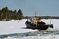
A U.S. Coast Guard cutter breaks ice on the Kennebec River near Bath, Maine; March 2005
-
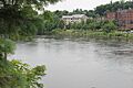
The Kennebec at the capital city of Augusta
-
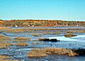
The Kennebec River just south of Bath


See also
 In Spanish: Río Kennebec para niños
