
Winslow, Maine facts for kids
Quick facts for kids
Winslow, Maine
|
||
|---|---|---|

Congregational Church
|
||
|
||

Location in Kennebec County and the state of Maine.
|
||
| Country | United States | |
| State | Maine | |
| County | Kennebec | |
| Incorporated | April 26, 1771 | |
| Villages | Winslow East Winslow Hayden Corner Lambs Corner Paines Corner |
|
| Area | ||
| • Total | 6.61 sq mi (17.11 km2) | |
| • Land | 5.99 sq mi (15.52 km2) | |
| • Water | 0.61 sq mi (1.58 km2) | |
| Elevation | 266 ft (81 m) | |
| Population
(2020)
|
||
| • Total | 7,948 | |
| • Density | 887.22/sq mi (342.58/km2) | |
| Time zone | UTC−5 (Eastern (EST)) | |
| • Summer (DST) | UTC−4 (EDT) | |
| ZIP code |
04901
|
|
| Area code(s) | 207 | |
| FIPS code | 23-86515 | |
| GNIS feature ID | 0582820 | |

Winslow is a town in Maine, United States. It's located in Kennebec County, right by the Kennebec River. Across the river from Winslow is the city of Waterville. In 2020, about 7,948 people lived in Winslow.
Contents
History of Winslow, Maine
Winslow was first a Native American settlement called Taconock. In 1692, during a conflict called King William's War, a military leader named Major Benjamin Church led soldiers to this area. They visited Native American villages, including the one where Winslow is now.
Early Settlers and Fort Halifax
Later, settlers from Plymouth Colony arrived in Winslow. The English Crown had given land rights to Pilgrim governor William Bradford and his friends. Some of the first families to settle here had names like Winslow, Bradford, Warren, and Otis. You can still find their descendants living in the town today.
In 1754, Fort Halifax was built in Winslow. The Massachusetts General Court ordered its construction. The fort was placed on a piece of land where the Sebasticook River meets the Kennebec River. A town grew around the fort for protection. It was named after General John Winslow. He was in charge of building the fort.
General Winslow was related to Edward Winslow, an important Pilgrim governor. Edward Winslow arrived on the Mayflower and helped found Plymouth Colony. The historic Winslow House, built in 1699 by General Winslow's father, still stands in Marshfield, Massachusetts. It's now a recognized historic place.
Rivers and Industry
The Sebasticook and Kennebec rivers were very important. They served as main routes for transporting food, goods, and new settlers. During the American Revolutionary War, in 1775, Benedict Arnold traveled north along the Kennebec River. He stopped at Fort Halifax in Winslow during his attempt to invade Canada.
The original Fort Halifax blockhouse was swept away by a flood in 1987. However, it was rebuilt. This blockhouse is the oldest wooden structure of its kind in the United States.
In the 1800s, many Irish and French Canadian immigrants came to the area. They used the Old Canada Road, which is now U.S. Route 201. They found jobs in the Kennebec River Valley and made it their home. Early settlers in Winslow used the power of the rivers to build industries.
Modern Winslow's Development
Modern Winslow grew around the Hollingsworth & Whitney Company paper mill. This large mill was located along the Kennebec River. Later, the Scott Paper Company bought the mill. In 1995, Scott Paper Company merged with Kimberly-Clark. This led to the factory closing in 1997.
Winslow's industrial activity started to slow down in the 1980s. However, some smaller businesses still exist, and new ones continue to open. Today, Winslow is often called a "bedroom community." This means many people who live there travel to nearby cities like Waterville and Augusta for work.
Winslow in Pop Culture
Some scenes from the 2005 TV show Empire Falls were filmed in Winslow. This show starred famous actors like Paul Newman, Ed Harris, and Helen Hunt. It was based on a book by Richard Russo.
For many years, Winslow hosted Maine's largest July 4 fireworks display. This big event moved to Clinton, Maine, in 2016.
Geography of Winslow
Winslow is located at 44°32′33″N 69°36′18″W / 44.542428°N 69.605101°W.
Area and Rivers
According to the United States Census Bureau, Winslow covers about 38.67 square miles (100.15 square kilometers). Most of this area, about 36.82 square miles (95.36 square kilometers), is land. The rest, about 1.85 square miles (4.79 square kilometers), is water. Winslow is situated where the Sebasticook River flows into the Kennebec River.
Transportation and Neighboring Towns
Several important roads pass through Winslow. These include U.S. Route 201 and State Routes 11, 32, 100, and 137.
Winslow shares its borders with several other towns:
- To the north: Benton
- To the east: Albion
- To the southeast: China
- To the south: Vassalboro
- To the west (across the Kennebec River): Waterville
Population of Winslow
| Historical population | |||
|---|---|---|---|
| Census | Pop. | %± | |
| 1790 | 797 | — | |
| 1800 | 1,250 | 56.8% | |
| 1810 | 658 | −47.4% | |
| 1820 | 935 | 42.1% | |
| 1830 | 1,263 | 35.1% | |
| 1840 | 1,722 | 36.3% | |
| 1850 | 1,796 | 4.3% | |
| 1860 | 1,739 | −3.2% | |
| 1870 | 1,437 | −17.4% | |
| 1880 | 1,467 | 2.1% | |
| 1890 | 1,814 | 23.7% | |
| 1900 | 2,277 | 25.5% | |
| 1910 | 2,709 | 19.0% | |
| 1920 | 3,280 | 21.1% | |
| 1930 | 3,917 | 19.4% | |
| 1940 | 4,153 | 6.0% | |
| 1950 | 4,413 | 6.3% | |
| 1960 | 5,891 | 33.5% | |
| 1970 | 7,299 | 23.9% | |
| 1980 | 8,057 | 10.4% | |
| 1990 | 7,997 | −0.7% | |
| 2000 | 7,743 | −3.2% | |
| 2010 | 7,794 | 0.7% | |
| 2020 | 7,948 | 2.0% | |
| U.S. Decennial Census | |||
Population in 2010
In 2010, the census showed that 7,794 people lived in Winslow. There were 3,328 households and 2,183 families. The town had about 211.7 people per square mile (81.7 per square kilometer).
Most of the people in Winslow were White (96.0%). A small number were African American (0.4%), Native American (0.6%), or Asian (0.6%). About 1.1% of the population identified as Hispanic or Latino.
About 28.7% of households had children under 18. Many households (50.3%) were married couples living together. The average age of people in Winslow was 43.6 years.
Economy
For much of the 1900s, paper mills were the most important part of Winslow's economy.
Current Businesses
In 2002, Johnny’s Selected Seeds moved its main office to Winslow. This company is owned by its employees and sells seeds to gardeners across the United States.
Other major employers in Winslow today include:
- Mid-State Machine Products
- Lohmann Animal Health International
- Orion Rope Works
- Northeast Laboratories
Education
Winslow Public Schools operates three public schools within two buildings. There used to be a private Catholic school, St. John's, but it closed in 2020.
School Buildings
Winslow High School was updated in 2008 with a $9,000,000 renovation. Another project finished in 2020 added a junior high wing and a band room. It also made the gym and cafeteria bigger.
- Winslow Elementary School teaches students from Pre-Kindergarten to 6th grade.
- The middle school building houses grades 7 and 8.
- The high school building houses grades 9 through 12.
Before 2020, the middle school was in a different building. But that building was getting old, so it closed. Now, 6th graders go to the elementary school, and 7th and 8th graders attend the high school in a new section.
Places to Visit
- Camp Caribou
- Two Cent Bridge
- Fort Halifax
Notable People from Winslow
Many interesting people have come from Winslow, including:
- Sharon H. Abrams, who leads the Maine Children's Home for Little Wanderers.
- Mike Cowan, a well-known golf caddy.
- Joshua Cushman, a minister and US congressman.
- Charles Fletcher Johnson, a US senator.
- Sharon Lee, a science-fiction author.
- Stan Meserve, a racing driver.
- Steve Miller, another science-fiction author.
- Frank Pooler, a Wisconsin politician and businessman.
- Thomas Rice, a US congressman.
- Samuel Francis Smith, a minister and author.
Images for kids
-
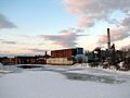
Scott Paper mill (originally Hollingsworth & Whitney) 10 years after the Kimberly Clark closing

See also
 In Spanish: Winslow (Maine) para niños
