
Waterville, Maine facts for kids
Quick facts for kids
Waterville, Maine
|
||
|---|---|---|

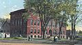
City Hall and Opera House in 1905
|
||
|
||
| Nickname(s):
Elm City
|
||

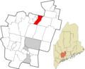
Location in Kennebec County and the state of Maine.
|
||

Waterville, Maine
Location in the United States
|
||
| Country | United States | |
| State | Maine | |
| County | Kennebec | |
| Incorporated (town) | June 23, 1802 | |
| Incorporated | January 12, 1888 | |
| Government | ||
| • Type | Mayor and council-manager | |
| • Body | Waterville City Council | |
| Area | ||
| • Total | 14.01 sq mi (36.28 km2) | |
| • Land | 13.53 sq mi (35.05 km2) | |
| • Water | 0.47 sq mi (1.23 km2) | |
| Elevation | 108 ft (33 m) | |
| Population
(2020)
|
||
| • Total | 15,828 | |
| • Density | 1,169.67/sq mi (451.60/km2) | |
| Time zone | UTC−5 (Eastern (EST)) | |
| • Summer (DST) | UTC−4 (EDT) | |
| ZIP Code |
04901
|
|
| Area code(s) | 207 | |
| FIPS code | 23-80740 | |
| GNIS feature ID | 0577893 | |


Waterville is a city in Kennebec County, Maine, United States. It sits on the west side of the Kennebec River. Waterville is known as a college town. It is home to two colleges: Colby College and Thomas College.
In 2020, about 15,828 people lived in Waterville. It is one of the main cities in the Augusta-Waterville, ME Micropolitan Statistical Area. This means it is an important center for jobs and services in the area.
Contents
History of Waterville
Early Days and Native Americans
The land where Waterville is now was once home to the Canibas tribe. They were part of the Abenaki people. Their main village was called "Taconnet." It was located on the east side of the Kennebec River. This area is now Winslow.
In 1692, during King William's War, the village was burned. The Canibas tribe then left the area. Later, in 1754, Fort Halifax was built by General John Winslow. The last fight with Native Americans in this area happened in 1757.
How Waterville Became a Town
The area was first called Kingfield Plantation. Then, in 1771, it became the town of Winslow. People living on the west side of the Kennebec River found it hard to cross for town meetings. So, on June 23, 1802, the western part of Winslow became its own town, called Waterville.
In 1824, a bridge was built to connect Waterville and Winslow. Early jobs in Waterville included fishing, lumbering, agriculture, and ship building. Large boats were launched in the spring when the river waters were high. By the early 1900s, there were five shipyards in the community.
Growth and Industry
The Ticonic Falls stopped boats from going further upriver. This made Waterville a key place for trade and shipping. The Kennebec River and Messalonskee Stream provided water power for many mills. These included sawmills, a gristmill, and factories making furniture and shovel handles. There were also places that made carriages, boots, bricks, and leather.
In 1849, the Androscoggin and Kennebec Railroad came to Waterville. This railroad later became part of the Maine Central Railroad. In 1870, the railroad built shops in Waterville to fix trains. This helped the city grow as a busy mill town. Waterville officially became a city on January 12, 1888.
Mills and Bridges
In 1866, the Ticonic Water Power & Manufacturing Company was formed. They built a dam across the Kennebec River. Later, this company built the Lockwood Manufacturing Company, which made cotton textiles. By 1900, this company was very big and employed 1,300 workers. The Lockwood Mills closed in the mid-1950s.
The Waterville-Winslow Footbridge opened in 1901. It was for people from Waterville to walk to work in Winslow's mills. But less than a year later, a big flood washed it away. It was rebuilt in 1903 and was called the Two Cent Bridge because people paid a small toll to cross it.
Education in Waterville
Waterville also became a center for learning. In 1813, the Maine Literary and Theological Institution was started. It later became Waterville College in 1821, and then Colby College in 1867. Thomas College was founded in 1894.
Many other schools were also started to prepare students for college. The first public high school was built in 1877. The current Waterville Senior High School was built in 1961.
Geography and Climate
Where is Waterville Located?
Waterville is in the northern part of Kennebec County, in central Maine. It is next to the Somerset County line. The city covers about 14.05 square miles (36.28 square kilometers). Most of this is land, with a small amount of water. The Kennebec River runs next to Waterville, and the Messalonskee Stream flows through it.
How to Get Around Waterville
Several major roads serve Waterville. These include Interstate 95, U.S. Route 201, and Maine State Routes 137 and 104. The city is surrounded by other towns like Fairfield, Winslow, Sidney, and Oakland.
Waterville's Weather
Waterville has a humid continental climate. This means it has big changes in temperature throughout the year. Summers are warm to hot and often humid. Winters are cold, sometimes very cold.
| Climate data for Waterville, Maine, 1991–2020 normals, extremes 1896–present | |||||||||||||
|---|---|---|---|---|---|---|---|---|---|---|---|---|---|
| Month | Jan | Feb | Mar | Apr | May | Jun | Jul | Aug | Sep | Oct | Nov | Dec | Year |
| Record high °F (°C) | 61 (16) |
63 (17) |
84 (29) |
92 (33) |
98 (37) |
98 (37) |
101 (38) |
101 (38) |
96 (36) |
90 (32) |
75 (24) |
67 (19) |
101 (38) |
| Mean maximum °F (°C) | 49.8 (9.9) |
49.7 (9.8) |
58.4 (14.7) |
74.0 (23.3) |
85.1 (29.5) |
89.7 (32.1) |
91.1 (32.8) |
90.2 (32.3) |
86.4 (30.2) |
75.1 (23.9) |
64.4 (18.0) |
53.2 (11.8) |
93.1 (33.9) |
| Mean daily maximum °F (°C) | 28.5 (−1.9) |
31.8 (−0.1) |
40.3 (4.6) |
53.4 (11.9) |
65.8 (18.8) |
74.7 (23.7) |
80.1 (26.7) |
79.5 (26.4) |
71.7 (22.1) |
58.7 (14.8) |
46.1 (7.8) |
34.5 (1.4) |
55.4 (13.0) |
| Daily mean °F (°C) | 18.7 (−7.4) |
20.9 (−6.2) |
30.4 (−0.9) |
42.9 (6.1) |
54.5 (12.5) |
63.9 (17.7) |
69.6 (20.9) |
68.5 (20.3) |
60.6 (15.9) |
48.5 (9.2) |
37.4 (3.0) |
25.9 (−3.4) |
45.2 (7.3) |
| Mean daily minimum °F (°C) | 8.8 (−12.9) |
9.9 (−12.3) |
20.5 (−6.4) |
32.2 (0.1) |
43.2 (6.2) |
53.1 (11.7) |
59.1 (15.1) |
57.4 (14.1) |
49.5 (9.7) |
38.4 (3.6) |
28.7 (−1.8) |
17.2 (−8.2) |
34.8 (1.6) |
| Mean minimum °F (°C) | −11.7 (−24.3) |
−8.8 (−22.7) |
−0.9 (−18.3) |
20.4 (−6.4) |
31.1 (−0.5) |
41.6 (5.3) |
49.6 (9.8) |
46.8 (8.2) |
35.6 (2.0) |
25.6 (−3.6) |
13.7 (−10.2) |
−2.1 (−18.9) |
−14.9 (−26.1) |
| Record low °F (°C) | −36 (−38) |
−35 (−37) |
−20 (−29) |
−1 (−18) |
21 (−6) |
26 (−3) |
37 (3) |
31 (−1) |
23 (−5) |
10 (−12) |
−6 (−21) |
−39 (−39) |
−39 (−39) |
| Average precipitation inches (mm) | 3.12 (79) |
2.61 (66) |
3.27 (83) |
3.73 (95) |
3.33 (85) |
4.03 (102) |
3.37 (86) |
3.39 (86) |
3.82 (97) |
4.90 (124) |
3.87 (98) |
3.92 (100) |
43.36 (1,101) |
| Average snowfall inches (cm) | 17.4 (44) |
17.0 (43) |
12.0 (30) |
2.2 (5.6) |
0.0 (0.0) |
0.0 (0.0) |
0.0 (0.0) |
0.0 (0.0) |
0.0 (0.0) |
0.1 (0.25) |
2.2 (5.6) |
14.5 (37) |
65.4 (165.45) |
| Average extreme snow depth inches (cm) | 13.9 (35) |
15.4 (39) |
13.5 (34) |
3.1 (7.9) |
0.0 (0.0) |
0.0 (0.0) |
0.0 (0.0) |
0.0 (0.0) |
0.0 (0.0) |
0.1 (0.25) |
1.5 (3.8) |
8.9 (23) |
19.3 (49) |
| Average precipitation days (≥ 0.01 in) | 10.7 | 9.4 | 9.8 | 11.3 | 12.5 | 12.9 | 12.3 | 10.5 | 10.2 | 12.0 | 11.2 | 11.9 | 134.7 |
| Average snowy days (≥ 0.1 in) | 7.4 | 6.5 | 4.4 | 1.0 | 0.0 | 0.0 | 0.0 | 0.0 | 0.0 | 0.1 | 1.6 | 6.0 | 27 |
| Source 1: NOAA | |||||||||||||
| Source 2: National Weather Service | |||||||||||||
People of Waterville: Demographics


The population of Waterville has changed over the years. Here's a look at how many people have lived there:
| Historical population | |||
|---|---|---|---|
| Census | Pop. | %± | |
| 1810 | 1,314 | — | |
| 1820 | 1,719 | 30.8% | |
| 1830 | 2,216 | 28.9% | |
| 1840 | 2,971 | 34.1% | |
| 1850 | 3,964 | 33.4% | |
| 1860 | 4,390 | 10.7% | |
| 1870 | 4,852 | 10.5% | |
| 1880 | 4,672 | −3.7% | |
| 1890 | 7,107 | 52.1% | |
| 1900 | 9,477 | 33.3% | |
| 1910 | 11,458 | 20.9% | |
| 1920 | 13,351 | 16.5% | |
| 1930 | 15,454 | 15.8% | |
| 1940 | 16,688 | 8.0% | |
| 1950 | 18,287 | 9.6% | |
| 1960 | 18,695 | 2.2% | |
| 1970 | 18,192 | −2.7% | |
| 1980 | 17,779 | −2.3% | |
| 1990 | 17,173 | −3.4% | |
| 2000 | 15,605 | −9.1% | |
| 2010 | 15,722 | 0.7% | |
| 2020 | 15,828 | 0.7% | |
| U.S. Decennial Census | |||
What the 2010 Census Showed
In 2010, there were 15,722 people living in Waterville. There were 6,370 households, which are groups of people living together. The city had about 1,158 people per square mile.
Most people in Waterville were White (93.9%). There were also smaller groups of African American, Native American, and Asian people. About 2.4% of the population identified as Hispanic or Latino.
About 24.8% of households had children under 18. The average household had 2.13 people. The average age in the city was 36.8 years old.
Economy and Jobs
Changes in Downtown Waterville
Like many other towns, Waterville has seen new growth outside the city center. Big stores like Walmart and Home Depot have opened in the northern part of the city. This growth has led to changes in the downtown area.
Some older stores in downtown Waterville have closed. However, efforts are being made to bring new life to the downtown area. Colby College has built a new dorm for students on Main Street. The Lockwood Hotel also opened in 2022. A new art center, the Paul J. Schupf Art Center, is also being built.
Top Employers in Waterville
Many different places offer jobs in Waterville. Some of the biggest employers include:
- MaineGeneral Medical Center
- Colby College
- HealthReach Community Health Centers
- Northern Light Inland Hospital
- Hannaford Supermarket
- Shaw's Supermarket
- Wal-Mart
- Mount St. Joseph Nursing Home
- Kennebec Valley Community Action Program
- Thomas College
- City of Waterville
- The Woodlands Residential Care
- Central Maine Newspapers
Transportation in Waterville
Waterville has several ways to get around and connect to other places:
- Robert LaFleur Airport
- Interstate 95 (a major highway)
- US Route 201
- Several Maine State Routes: 100A, 137, 32, 137 Business, 11, and 104.
- Pan Am Railways – Waterville Intermodal Facility (for train transport)
Education in Waterville
Public Schools
Waterville Public Schools provides education for students from kindergarten through high school.
Colleges and Universities
Waterville is home to several colleges:
- Kennebec Valley Community College in Fairfield is a public community college.
- Colby College is a private four-year college. It is one of the top liberal arts colleges in Maine.
- Thomas College is also a private four-year college located in the city.
Media and Culture
Local News and Radio
Waterville has its own daily newspaper, the Morning Sentinel. Students at Colby College also publish a weekly newspaper called The Colby Echo.
The city has several radio stations, including:
Waterville in Movies
The 2001 comedy movie Wet Hot American Summer is set near Waterville. Some scenes in the movie even take place in the city. Although the movie was filmed in Pennsylvania, signs in the film show "Waterville Maine Est. 1802 Pop. 17,173."
Sister City
Waterville has a special connection with a city in Russia:
 Kotlas, Arkhangelsk Oblast, Russia
Places to Visit in Waterville
There are many interesting places to see and things to do in Waterville:
- Colby College
- Colby College Museum of Art
- Thomas College
- Atlantic Music Festival
- Maine International Film Festival
- Old Waterville High School
- Old Waterville Post Office
- Perkins Arboretum (a place with many trees and plants)
- Waterville Historical Society - Redington Museum (learn about the city's past)
- Waterville Public Library
- Waterville Opera House (for performances and shows)
- Waterville Main Street (the downtown area)
- Waterville – Winslow Footbridge (Two Cent Bridge)
Notable People
To learn about famous people from Waterville, see the main article: List of people from Waterville, Maine.
Images for kids
-
City Hall and Opera House in 1905
-
Seal of Waterville, Maine
-
Location in Kennebec County and Maine
-
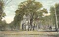
Silver and Elm streets (1910)
See also
 In Spanish: Waterville (Maine) para niños
