
Oakland, Maine facts for kids
Quick facts for kids
Oakland, Maine
|
|
|---|---|

Oakland, Maine in January 2012
|
|

Location in Kennebec County and the state of Maine.
|
|
| Country | United States |
| State | Maine |
| County | Kennebec |
| Incorporated | 1873 |
| Village | Oakland |
| Area | |
| • Total | 28.17 sq mi (72.96 km2) |
| • Land | 25.67 sq mi (66.48 km2) |
| • Water | 2.50 sq mi (6.47 km2) |
| Elevation | 433 ft (132 m) |
| Population
(2020)
|
|
| • Total | 6,230 |
| • Density | 243/sq mi (93.7/km2) |
| Time zone | UTC-5 (Eastern (EST)) |
| • Summer (DST) | UTC-4 (EDT) |
| ZIP code |
04963
|
| Area code(s) | 207 |
| FIPS code | 23-54560 |
| GNIS feature ID | 0582645 |
| Website | Town website |
Oakland is a town in Kennebec County, located in the U.S. state of Maine. In 2020, about 6,230 people lived here. Oakland is just a few miles west of Waterville. It is also about 18 miles (29 km) north of Augusta, which is Maine's capital city. Many Oakland residents travel to Waterville and Augusta for their jobs.
Contents
History of Oakland
Early Days in Taconnet
The area that is now Oakland was first settled around 1780. These early settlers were colonists from English families. They came from places like Massachusetts and New Hampshire. At that time, the region was called Taconnet. This name came from Chief Taconnet, a leader of the Abenaki Native American people.
The land was very good for farming. Farmers found the soil fertile for growing crops and raising animals. The Messalonskee Stream also provided strong water power. This power was useful for running factories. In 1771, this area became part of Winslow.
Becoming Waterville
In 1802, the part of Winslow that was west of the Kennebec River became its own town. It was named Waterville.
The Androscoggin and Kennebec Railroad arrived in 1849. This helped Waterville grow quickly as a mill town. Many factories made farm implements, like tools for farming. Waterville became known as the "axe and scythe capital" of New England. Other factories made canned goods, tinware, carriages, and furniture. They also produced tools, machinery, woolens, and lumber. There was even a granite quarry in the area.
Oakland's Own Identity
By the 1870s, some factory owners in western Waterville were unhappy with the town's taxes. They asked the Maine State Legislature to make their industrial area a separate town. In 1872, the Somerset Railroad reached Oakland. This connected it to other towns like North Anson and Bingham.
On February 26, 1873, the area officially became its own town. It was first called West Waterville. Then, in 1883, it was renamed Oakland.
Today, Oakland's ponds and lakes are popular for summer camps. The downtown area has interesting buildings. These include Memorial Hall, built in 1870, and the Oakland Public Library. The library was built between 1913 and 1915 and is a Carnegie library. Both buildings are listed on the National Register of Historic Places. In the 1960s, Interstate 95 was completed. This made it easier to travel between Oakland and cities like Augusta, Portland, and Bangor.
-

Messalonskee Stream around 1906
-
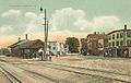
Depot Square in 1908
-

Oakland Public Library around 1920
-

Memorial Hall around 1920


Geography of Oakland
According to the United States Census Bureau, Oakland covers about 28.17 square miles (72.96 km²). Of this, 25.67 square miles (66.48 km²) is land. The remaining 2.50 square miles (6.47 km²) is water.
Oakland has four main waterways: McGrath Pond, Salmon Lake, East Pond, and Messalonskee Lake and Stream.
Major roads like Interstate 95 pass through the town. State routes 11, 23, 41, and 137 also cross Oakland. The town shares borders with Belgrade to the southwest and Smithfield to the northwest. To the north is Fairfield, and to the southeast is Waterville. Sidney is located to the south.
Population and People
| Historical population | |||
|---|---|---|---|
| Census | Pop. | %± | |
| 1880 | 1,647 | — | |
| 1890 | 2,044 | 24.1% | |
| 1900 | 1,913 | −6.4% | |
| 1910 | 2,257 | 18.0% | |
| 1920 | 2,473 | 9.6% | |
| 1930 | 2,664 | 7.7% | |
| 1940 | 2,730 | 2.5% | |
| 1950 | 2,679 | −1.9% | |
| 1960 | 3,075 | 14.8% | |
| 1970 | 3,535 | 15.0% | |
| 1980 | 5,162 | 46.0% | |
| 1990 | 5,595 | 8.4% | |
| 2000 | 5,959 | 6.5% | |
| 2010 | 6,240 | 4.7% | |
| 2020 | 6,230 | −0.2% | |
| U.S. Decennial Census | |||
2010 Census Information
In 2010, the census showed that 6,240 people lived in Oakland. There were 2,543 households and 1,793 families. The town had about 243 people per square mile (93.7 per km²).
Most residents, 96.7%, were White. Other groups included 0.4% African American and 0.4% Native American. About 0.9% were Asian. People of Hispanic or Latino background made up 1.3% of the population.
About 32.2% of households had children under 18 living with them. Most households, 53.6%, were married couples. The average household had 2.45 people. The average family had 2.83 people.
The average age in Oakland was 42.3 years. About 22.8% of residents were under 18. About 13.2% were 65 years or older. There were slightly more females (51.5%) than males (48.5%).
Places to Visit
- Memorial Hall
- Oakland Area Historical Society & Museum
See also
 In Spanish: Oakland (Maine) para niños
