
Anson, Maine facts for kids
Quick facts for kids
Anson, Maine
|
|
|---|---|

Looking across the falls at downtown Anson, showing the town hall at left, January 2010
|
|

Anson, Maine
Location in Maine
|
|
| Country | United States |
| State | Maine |
| County | Somerset |
| Area | |
| • Total | 48.29 sq mi (125.07 km2) |
| • Land | 47.49 sq mi (123.00 km2) |
| • Water | 0.80 sq mi (2.07 km2) |
| Elevation | 440 ft (130 m) |
| Population
(2020)
|
|
| • Total | 2,291 |
| • Density | 48/sq mi (18.6/km2) |
| Time zone | UTC-5 (Eastern (EST)) |
| • Summer (DST) | UTC-4 (EDT) |
| ZIP Code |
04911
|
| Area code(s) | 207 |
| GNIS feature ID | 582326 |
Anson is a town in Somerset County, Maine, United States. In 2020, about 2,291 people lived there. The town includes two smaller areas called Anson and North Anson.
Contents
History of Anson
The land where Anson is located was originally home to the Norridgewock Abenaki people. The first settlers arrived in 1772. At that time, it was known as Plantation Number One.
In 1775, during the American Revolutionary War, General Benedict Arnold and his soldiers traveled through Anson village. They were on their way up the Kennebec River to the Battle of Quebec.
The town officially became Anson on March 1, 1798. It was named after Lord George Anson. North Anson briefly became a separate town in 1845 but reunited with Anson in 1855.
Anson had very fertile soil, which made it a great farming town. North Anson grew into a small mill town because of the water power from the Carrabassett River. By 1859, it had two places that made leather, called tanneries. Later, it also had sawmills and factories that made boots and shoes.
In 1876, North Anson became the end point for the Somerset Railroad. As the nearby town of Madison grew with large paper mills, many people who worked in those mills chose to live in Anson.
A railroad track that had been closed for 20 years was reopened in 2007. However, it was closed again in 2013. In 2021, the State of Maine bought the old rail line. They plan to turn it into a path for walking and biking, connecting Oakland to Embden.
Geography of Anson
Anson covers about 48.29 square miles (125.07 square kilometers). Most of this area is land, with a small part being water. Several streams and rivers flow through Anson, including Mill Stream, Gilbert Brook, Lemon Stream, the Carrabassett River, and the Kennebec River.
The town is connected by several roads, including U.S. 201A and state routes 8, 16, 43, 148, and 234. Anson shares its borders with several other towns: Starks to the south, Industry and New Vineyard to the west, New Portland and Embden to the north, and Madison to the east (across the Kennebec River).
Anson's Climate
Anson has a humid continental climate. This means it has big changes in temperature throughout the year. Summers are warm to hot, and often humid. Winters are cold, and sometimes very cold.
People in Anson
In 2010, there were 2,511 people living in Anson. There were 1,069 households, and 684 families. The town had about 52.9 people per square mile.
Most of the people in Anson were White (97.2%). A small number were African American, Native American, or Asian. About 1% of the population was Hispanic or Latino.
About 27.5% of households had children under 18 living with them. Many households (46.9%) were married couples. The average age of people in Anson was 44.3 years old.
Notable people
- Frank H. Holley, a politician who served in the Maine state government
- Eugene H. Merrill, a scholar who studied the Old Testament
- Lloyd T. Pullen, a politician who served in the Wisconsin state government
- Gage M. Nelson, an American business person
- Isaiah Dunphy, an American business person
- Larry Dunphy, an American politician
Images for kids
-
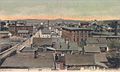
An old picture of Madison mills and a view of Anson from above, around 1906.

See also
 In Spanish: Anson (Maine) para niños
