
Bingham, Maine facts for kids
Quick facts for kids
Bingham, Maine
|
|
|---|---|

Welcome sign
|
|

Bingham, Maine
Location in Maine
|
|
| Country | United States |
| State | Maine |
| County | Somerset |
| Settled | 1785 |
| Incorporated | February 6, 1812 |
| Area | |
| • Total | 35.32 sq mi (91.48 km2) |
| • Land | 34.91 sq mi (90.42 km2) |
| • Water | 0.41 sq mi (1.06 km2) 1.16% |
| Elevation | 728 ft (222 m) |
| Population
(2020)
|
|
| • Total | 866 |
| • Density | 25/sq mi (9.6/km2) |
| Time zone | UTC-5 (Eastern (EST)) |
| • Summer (DST) | UTC-4 (EDT) |
| ZIP code |
04920
|
| Area code(s) | 207 |
| FIPS code | 23-05000 |
| GNIS feature ID | 0582354 |
Bingham is a small town in Somerset County, Maine, United States. It's a historic place located right next to the Kennebec River. In 2020, about 866 people lived there.
Most of the people in Bingham live in the main part of town, which is known as the Bingham census-designated place.
Contents
History of Bingham
Bingham was first settled in 1785. The town gets its name from William Bingham, who was a banker and politician from Philadelphia. He once owned a huge amount of land in Maine, about two million acres, which was known as the Bingham Purchase.
The community officially became a town on February 6, 1812. By 1859, about 752 people lived there. At that time, Bingham had two sawmills that used water power to cut wood and two gristmills that ground grain.
Bingham is located on the Old Canada Road, which is now U. S. Route 201. From 1820 to 1860, this road was the main connection between Lower Canada (now part of Quebec) and Maine. Bingham also became an important place for the Maine Central Railroad. They would load pulpwood (wood used to make paper) that was floated down the Kennebec River. This continued until the 1970s, when new rules about protecting the environment stopped the practice of floating logs down the river.
Geography of Bingham
Bingham covers a total area of about 35.32 square miles (91.48 square kilometers). Most of this area, about 34.91 square miles (90.42 square kilometers), is land. The rest, about 0.41 square miles (1.06 square kilometers), is water. The town's water flows into Jackson Brook and the Kennebec River.
The main roads that go through Bingham are U.S. Route 201 and Maine State Route 16. Bingham shares its borders with a few other towns: Moscow to the north, Brighton Plantation to the east, and Solon to the south.
Bingham's Climate
Bingham has a type of weather called a humid continental climate. This means the town experiences big changes in temperature throughout the year. Summers are usually warm to hot, and sometimes humid. Winters are cold, and can sometimes be very cold.
People of Bingham
| Historical population | |||
|---|---|---|---|
| Census | Pop. | %± | |
| 1820 | 336 | — | |
| 1830 | 537 | 59.8% | |
| 1840 | 751 | 39.9% | |
| 1850 | 752 | 0.1% | |
| 1860 | 831 | 10.5% | |
| 1870 | 826 | −0.6% | |
| 1880 | 828 | 0.2% | |
| 1890 | 757 | −8.6% | |
| 1900 | 841 | 11.1% | |
| 1910 | 775 | −7.8% | |
| 1920 | 1,143 | 47.5% | |
| 1930 | 1,592 | 39.3% | |
| 1940 | 1,210 | −24.0% | |
| 1950 | 1,354 | 11.9% | |
| 1960 | 1,308 | −3.4% | |
| 1970 | 1,254 | −4.1% | |
| 1980 | 1,184 | −5.6% | |
| 1990 | 1,230 | 3.9% | |
| 2000 | 989 | −19.6% | |
| 2010 | 922 | −6.8% | |
| 2020 | 866 | −6.1% | |
| U.S. Decennial Census | |||
In 2010, there were 922 people living in Bingham. Most of the people were White (97.0%). A small number of residents were African American, Native American, or Asian. Some people identified with two or more races. About 0.8% of the population was Hispanic or Latino.
The average age of people in Bingham was about 45.7 years old. About 19.2% of the residents were under 18 years old.
Famous People from Bingham
- Gadabout Gaddis – He was a pioneer in early television. He lived in Bingham, and the Gadabout Gaddis Airport was his main base. He bought the airport, which was built around 1950.
- Bill Potter – He was a "singing cowboy" musician. He was born in Stratton but grew up in Bingham.
Images for kids
-
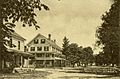
Bingham Hotel and Main Street in 1905
-

The Somerset Railroad trestle in 1910
-
An old mill in 1909


See also
 In Spanish: Bingham (Maine) para niños
