
Solon, Maine facts for kids
Quick facts for kids
Solon, Maine
|
|
|---|---|

Kennebec River c. 1908
|
|

Solon, Maine
Location in Maine
|
|
| Country | United States |
| State | Maine |
| County | Somerset |
| Incorporated | 1809 |
| Area | |
| • Total | 40.74 sq mi (105.52 km2) |
| • Land | 39.65 sq mi (102.69 km2) |
| • Water | 1.09 sq mi (2.82 km2) |
| Elevation | 499 ft (152 m) |
| Population
(2020)
|
|
| • Total | 978 |
| • Density | 25/sq mi (9.5/km2) |
| Time zone | UTC-5 (Eastern (EST)) |
| • Summer (DST) | UTC-4 (EDT) |
| ZIP code |
04979
|
| Area code(s) | 207 |
| FIPS code | 23-69505 |
| GNIS feature ID | 0582728 |
Solon is a small town located in Somerset County, Maine, in the United States. According to the 2020 census, 978 people live there. It's known for its history and natural beauty along the Kennebec River.
Contents
History of Solon

The first people known to live in this area were the Abenaki Indians. European settlers met them in the early 1600s. You can still find ancient Native American carvings on a rock ledge near the Kennebec River. These carvings are about 3 miles from the center of Solon and date back to 900-1400 CE.
A famous American general, Benedict Arnold, and his soldiers camped near Caratunk Falls on October 7, 1775. They were on their way up the Kennebec River to the Battle of Quebec. They had to carry their boats around the falls.
The area was first called T1 R2 EKR. It was also known as Spauldingtown, named after Thomas Spaulding. The first settler, William Hilton from Wiscasset, arrived in 1782. He bought about 500 acres (2.0 km²). On February 23, 1809, the area officially became a town called Solon. It was named after Solon, a wise statesman and poet from Ancient Greece.
Early Life and Industries
Farming was the main job for people living in Solon. The land was uneven, with slate rock underneath. However, the sandy and sometimes gravelly soil was good for growing hay and grain.
Solon village grew around Fall Brook. The power from the water was used to run mills. By 1859, when 1,419 people lived in Solon, there were several businesses. These included two sawmills, a gristmill (for grinding grain), a factory making shovel handles, and places for processing wool. There were also two blacksmiths. By 1886, the town also had a company that made carriages and another that made harnesses for horses.
Solon is seen as the start of the Old Canada Road (U.S. Route 201). From 1820 to 1860, this road was the main connection between Lower Canada (now part of Quebec) and Maine. The road follows the Kennebec River valley. It goes through different villages and into the forests near the Canada–US border.
Geography of Solon
Solon covers a total area of about 40.74 square miles (105.52 km²). Most of this, 39.65 square miles (102.69 km²), is land. The rest, 1.09 square miles (2.82 km²), is water.
The town has several waterways. Fall Brook and Michael Stream flow through it. The Kennebec River also runs through Solon. At Caratunk Falls on the Kennebec River, the water drops about 20 feet (6.1 m).
Major roads that cross Solon include U.S. Route 201, 201A, and Maine State Route 8. Solon shares its borders with several other towns. To the north are Bingham and Brighton Plantation. To the east is Athens. To the south are Cornville and Madison. To the west is Embden.
Population Information
| Historical population | |||
|---|---|---|---|
| Census | Pop. | %± | |
| 1800 | 38 | — | |
| 1810 | 312 | 721.1% | |
| 1820 | 468 | 50.0% | |
| 1830 | 768 | 64.1% | |
| 1840 | 1,139 | 48.3% | |
| 1850 | 1,415 | 24.2% | |
| 1860 | 1,345 | −4.9% | |
| 1870 | 1,176 | −12.6% | |
| 1880 | 1,013 | −13.9% | |
| 1890 | 977 | −3.6% | |
| 1900 | 996 | 1.9% | |
| 1910 | 1,034 | 3.8% | |
| 1920 | 1,054 | 1.9% | |
| 1930 | 852 | −19.2% | |
| 1940 | 773 | −9.3% | |
| 1950 | 746 | −3.5% | |
| 1960 | 669 | −10.3% | |
| 1970 | 712 | 6.4% | |
| 1980 | 827 | 16.2% | |
| 1990 | 916 | 10.8% | |
| 2000 | 940 | 2.6% | |
| 2010 | 1,053 | 12.0% | |
| 2020 | 978 | −7.1% | |
| U.S. Decennial Census | |||
2010 Census Details
In 2010, the town of Solon had 1,053 people living there. These people lived in 459 households, and 292 of these were families. The population density was about 26.6 people per square mile (10.3 people per km²). There were 657 housing units, which means homes or apartments.
Most of the people in Solon were White (97.9%). A small number were African American (0.2%), Native American (0.4%), or Asian (0.1%). About 1.4% of the population identified as being from two or more races. People of Hispanic or Latino background made up 0.4% of the population.
Out of the 459 households, 26.4% had children under 18 living with them. More than half (52.5%) were married couples living together. About 5.9% had a female head of household with no husband present. And 5.2% had a male head of household with no wife present. About 36.4% of households were not families.
About 27.0% of all households had only one person living in them. And 8.3% had someone living alone who was 65 years old or older. The average household had 2.29 people, and the average family had 2.75 people.
The average age of people in Solon in 2010 was 45.4 years. About 20.1% of residents were under 18 years old. About 5.1% were between 18 and 24. People aged 25 to 44 made up 24.2% of the population. The largest group, 35.6%, was between 45 and 64 years old. And 15.1% were 65 years or older. There were slightly more males (52.6%) than females (47.4%) in the town.
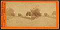
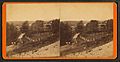
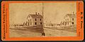
Old Photographs of Solon
Here are some stereoscopic photographs of Solon from the Victorian era. These photos were taken in a special way that made them look 3D when viewed with a special device.
-
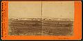
Solon village
-
Main Street
-
Pierce residence
-
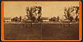
Jewett residence
-
Whipple residence
-
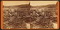
Logs on Caratunk Falls


_L._Pierce,_Solon,_Maine,_from_Robert_N._Dennis_collection_of_stereoscopic_views.jpg)


_Falls,_Solon,_Maine,_from_Robert_N._Dennis_collection_of_stereoscopic_views.jpg)
Places to Visit in Solon
- South Solon Meeting House (built in 1842): This historic building has cool frescos (wall paintings) from the 1950s. These were created by artists from the Skowhegan School of Painting & Sculpture.
- Evergreen Wilderness Chapel & 1800s Christian Museum: This is a replica of a country church from the 1800s. It also has a museum with Christian items from that time.
Famous Person from Solon
- George Washburn: He was a baseball pitcher who played one game for the New York Yankees in 1941.
See also
 In Spanish: Solon (Maine) para niños
