
Richmond, Maine facts for kids
Quick facts for kids
Richmond, Maine
|
|
|---|---|

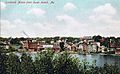
Main Street
|
|

Richmond, Maine
Location in Maine
|
|
| Country | United States |
| State | Maine |
| County | Sagadahoc |
| Incorporated | 1823 |
| Named for | Fort Richmond |
| Area | |
| • Total | 31.56 sq mi (81.74 km2) |
| • Land | 30.41 sq mi (78.76 km2) |
| • Water | 1.15 sq mi (2.98 km2) |
| Elevation | 210 ft (64 m) |
| Population
(2020)
|
|
| • Total | 3,522 |
| • Density | 116/sq mi (44.7/km2) |
| Time zone | UTC-5 (Eastern (EST)) |
| • Summer (DST) | UTC-4 (EDT) |
| ZIP code |
04357
|
| Area code(s) | 207 |
| FIPS code | 23-62645 |
| GNIS feature ID | 0582695 |
| Website | www.richmondmaine.com |
Richmond is a town in Sagadahoc County, Maine, United States. In 2020, about 3,522 people lived there. It's part of the larger Portland area. Richmond is located at the top of Merrymeeting Bay.
The town is next to the Steve Powell Wildlife Management Area on Swan Island. This area is 2,019 acres and is a state-owned wildlife sanctuary. Swan Island is a popular spot for wildlife tourism, especially in the summer. It's also listed on the National Register of Historic Places.
Richmond is also known for its many beautiful Greek Revival style homes. These homes have a unique look for this part of Maine.
Contents
A Look Back: Richmond's History
Early Days and Fort Richmond
The land where Richmond and Gardiner are today was bought in 1649. Christopher Lawson bought it from the Abenaki Indians. Historians believe that Richmond and Swan Island were summer homes for the Abenaki people.
In 1719, Fort Richmond was built. The Province of Massachusetts Bay built it on the western bank of the Kennebec River. The fort was named after Ludovic Stewart, the first Duke of Richmond. It had a blockhouse, a trading post, a chapel, and living areas for soldiers. A strong fence called a palisade surrounded everything.
Battles and Changes
In 1722, during Dummer's War, warriors from Norridgewock attacked Fort Richmond. They burned houses and killed cattle, but the fort stayed strong. Other towns nearby were destroyed. The fort's defenses were made even stronger in 1723.
In 1724, 208 soldiers left Fort Richmond in 17 whaleboats. They traveled up the Kennebec River to attack Norridgewock. Fort Richmond was rebuilt in 1740. It was attacked again in 1750. In 1755, the fort was taken apart when new forts were built further up the river. These new forts included Shirley, Western, and Halifax.
Growth and New Beginnings
People started settling in Richmond in 1725. It was part of Bowdoinham until 1762. In 1790, John Plummer, a veteran from the Revolutionary War, received land here. His son built a house on Plummer Road around 1810 that is still standing today.
The Embargo of 1807 hurt the town's economy. It caused businesses to fail and led to a tough economic time. This lasted through the War of 1812.
Richmond officially became its own town on February 10, 1823. It was named after the old fort. Farmers in the area grew hay and potatoes. When steamboats arrived in the 1830s, Richmond became a busy center. It was important for shipbuilding and trade on the Kennebec River.
One of the most important shipbuilders was T. J. Southard. He is also seen as one of the town's "founding fathers." A factory that made brass was also started. The town also produced shoes, sails, and wood products. Richmond's best years were between 1835 and 1857. During this time, many beautiful Greek Revival buildings were built.
Richmond is also thought to have been a stop on the Underground Railroad. This was a secret network that helped enslaved people find freedom.
A Diverse Community
Richmond was once home to the largest group of Slavic-speaking people in the United States. People from Ukraine, Russia, and Poland moved here during World War II. They settled along the Kennebec Valley. In the 1950s and 1960s, many White Russian immigrants also came. They had fled the Bolshevik Revolution of 1917.
Richmond's Location and Natural Features
Richmond covers about 30.41 square miles of land and 1.15 square miles of water. Mill Brook, Abagadasset River, and the Kennebec River all flow through Richmond. Peacock Beach State Park is a state park in Richmond. It opened in May 2010 and is located on Pleasant Pond.

Population Changes Over Time
Richmond's population has changed quite a bit over the years. Here's a quick look at how many people have lived here:
| Historical population | |||
|---|---|---|---|
| Census | Pop. | %± | |
| 1830 | 1,308 | — | |
| 1840 | 1,604 | 22.6% | |
| 1850 | 2,056 | 28.2% | |
| 1860 | 2,739 | 33.2% | |
| 1870 | 2,442 | −10.8% | |
| 1880 | 2,658 | 8.8% | |
| 1890 | 3,082 | 16.0% | |
| 1900 | 2,049 | −33.5% | |
| 1910 | 1,858 | −9.3% | |
| 1920 | 1,724 | −7.2% | |
| 1930 | 1,964 | 13.9% | |
| 1940 | 2,063 | 5.0% | |
| 1950 | 2,217 | 7.5% | |
| 1960 | 2,185 | −1.4% | |
| 1970 | 2,168 | −0.8% | |
| 1980 | 2,627 | 21.2% | |
| 1990 | 3,072 | 16.9% | |
| 2000 | 3,298 | 7.4% | |
| 2010 | 3,411 | 3.4% | |
| 2020 | 3,522 | 3.3% | |
| U.S. Decennial Census | |||
What the 2010 Census Showed
In 2010, there were 3,411 people living in Richmond. There were 1,420 households, and 965 families. Most residents (97.3%) were White. About 29.6% of households had children under 18. The average age in town was 42.1 years.
Places to Visit in Richmond
- Richmond Historical & Cultural Society
- C. H. T. J. Southard House Museum—This house was built around 1870. It was updated in 1886.
Gallery
-
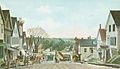
Main Street in 1908
-
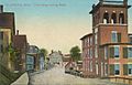
Front Street c. 1910
-
Swan Island ferry c. 1908
-
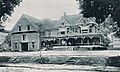
Maxwell residence in 1907
-
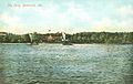
Richmond as seen from Swan Island, 1908


Famous People From Richmond
- De Alva S. Alexander—A journalist, lawyer, and US congressman.
- Walter A. Burleigh—A doctor and US congressman.
- Andrey Dikiy—A historian and writer.
- Seth Goodall—A Maine state senator.
- George Hamilton-Gordon—A Scottish earl and sailor.
- T. J. Southard—A shipbuilder, business owner, and politician. He was also a "founding father" of Richmond.
See also
 In Spanish: Richmond (Maine) para niños
