
Norridgewock, Maine facts for kids
Quick facts for kids
Norridgewock, Maine
|
|
|---|---|

Old Norridgewock Library
|
|
| Country | United States |
| State | Maine |
| County | Somerset |
| Area | |
| • Total | 51.21 sq mi (132.63 km2) |
| • Land | 49.95 sq mi (129.37 km2) |
| • Water | 1.26 sq mi (3.26 km2) |
| Population
(2020)
|
|
| • Total | 3,278 |
| • Density | 66/sq mi (25.3/km2) |
| Time zone | UTC-5 (Eastern (EST)) |
| • Summer (DST) | UTC-4 (EDT) |
Norridgewock is a town located in Somerset County, Maine, in the United States. In 2020, about 3,278 people lived there.
Contents
History of Norridgewock
Native American History
The area where Norridgewock is located was once home to the Norridgewock Indians. They were a group within the larger Abenaki nation. Their main village was at a place called Old Point, which is now part of Madison. This area was on the border between New England and a French territory called Acadia. The Kennebec River was often seen as the dividing line.
During the French and Indian Wars, there was a French missionary named Father Sebastien Rale living in the Native American village. English colonists thought he was helping the tribes fight against British settlements. In 1724, during a conflict known as Father Rale's War, soldiers from Fort Richmond (now Richmond) traveled to the village. On August 23, 1724, they arrived and a battle took place. This fight, known as the Battle of Norridgewock, was quick and decisive. Many warriors were killed or wounded, and about 150 survivors fled to Quebec, Canada. Father Rale was also killed in this battle.
Later Settlements and Growth
British settlers moved into the area in 1773. They called it Norridgewock Plantation. In 1775, during the American Revolutionary War, Benedict Arnold and his soldiers marched through Norridgewock on their way to the Battle of Quebec.
Norridgewock officially became a town on June 18, 1788. It became the main town, or county seat, for Somerset County in 1809. A courthouse was built in 1820. However, the county seat later moved to Skowhegan in 1871.
The town was important for its timber. Wooden logs were floated down the Kennebec River. A sawmill was built to process the many hardwood trees from the region. These hardwoods were used to make things like carriages and furniture in local factories. Norridgewock also had a mill for grinding grain and a place that worked with granite.
A famous landmark was the Norridgewock Covered Bridge, built in 1849. It was about 600 feet long and crossed the Kennebec River. This was the second longest covered bridge in Maine at the time.
The Eaton School was started in 1856 to help promote learning and good values. Its building, designed by architect Charles F. Douglas, later became a community hall. In 1988, it was recognized as a historic place.
Geography of Norridgewock
Norridgewock covers an area of about 51.21 square miles (132.63 square kilometers). Most of this area is land, with a small part being water. The town gets its water from the Sandy River, Mill Stream, and the Kennebec River.
The main part of Norridgewock is where several important roads meet. These include U.S. Routes 2 and 201A, along with Maine State routes 8 and 139. Norridgewock shares its borders with several other towns: Madison to the north, Skowhegan to the east, Fairfield and Smithfield to the south, and Mercer and Starks to the west.
Population Data
| Historical population | |||
|---|---|---|---|
| Census | Pop. | %± | |
| 1790 | 333 | — | |
| 1800 | 633 | 90.1% | |
| 1810 | 880 | 39.0% | |
| 1820 | 1,454 | 65.2% | |
| 1830 | 1,710 | 17.6% | |
| 1840 | 1,865 | 9.1% | |
| 1850 | 1,848 | −0.9% | |
| 1860 | 714 | −61.4% | |
| 1870 | 1,756 | 145.9% | |
| 1880 | 1,491 | −15.1% | |
| 1890 | 1,656 | 11.1% | |
| 1900 | 1,495 | −9.7% | |
| 1910 | 1,608 | 7.6% | |
| 1920 | 1,532 | −4.7% | |
| 1930 | 1,481 | −3.3% | |
| 1940 | 1,511 | 2.0% | |
| 1950 | 1,784 | 18.1% | |
| 1960 | 1,634 | −8.4% | |
| 1970 | 1,964 | 20.2% | |
| 1980 | 2,552 | 29.9% | |
| 1990 | 3,105 | 21.7% | |
| 2000 | 3,294 | 6.1% | |
| 2010 | 3,367 | 2.2% | |
| 2020 | 3,278 | −2.6% | |
| U.S. Decennial Census | |||
Population in 2010
In 2010, the town of Norridgewock had 3,367 people living in 1,378 households. About 30% of these households had children under 18. The average age of people in the town was 42.7 years. About 22% of the residents were under 18 years old.
Places to Visit
- Norridgewock Historical Society & Museum
- Everett's Tire
- Millstream Elementary School
Notable People from Norridgewock
Many interesting people have connections to Norridgewock, including:
- Nathan Abbott, a legal expert and professor
- Daniel W. Ames, a state lawmaker
- Rebecca Sophia Clarke (also known as Sophie May), a children's author
- Nathan Haskell Dole, an editor, translator, and author
- Stephen D. Lindsey, a U.S. congressman
- Sebastien Rale (or Rasle), a Jesuit missionary
- Minot Judson Savage, a minister
- Charles G. Sawtelle, a brigadier general in the U.S. Army
- Cullen Sawtelle, a U.S. congressman
- Franklin J. Sawtelle, an architect
- Niran Withee, a businessman and politician from Wisconsin
Images for kids
-
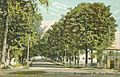
Main Street in 1904
-
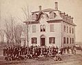
Eaton School around 1880
-
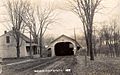
Covered bridge around 1912


See also
 In Spanish: Norridgewock (Maine) para niños
