
Farmington, Maine facts for kids
Quick facts for kids
Farmington, Maine
|
||
|---|---|---|

Downtown Farmington
|
||
|
||
| Nicknames:
Farmtown, The Farm
|
||

Location in Franklin County, Maine
|
||

Farmington, Maine
Location in Maine

Farmington, Maine
Location in the United States
|
||
| Country | United States | |
| State | Maine | |
| County | Franklin | |
| Incorporated | February 1, 1794 | |
| Villages | Farmington Farmington Falls Fairbanks West Farmington |
|
| Area | ||
| • Total | 55.82 sq mi (144.57 km2 km2) | |
| • Land | 55.67 sq mi (144.18 km2 km2) | |
| • Water | 0.15 sq mi (0.39 km2 km2) | |
| Elevation | 425 ft (130 m) | |
| Population
(2020)
|
||
| • Total | 7,592 | |
| • Density | 136/sq mi (52.7/km2) | |
| Time zone | UTC-5 (Eastern) | |
| • Summer (DST) | UTC-4 (Eastern) | |
| ZIP codes |
04938, 04992, 04940
|
|
| Area code(s) | 207 Exchanges: 778,779,860 | |

Farmington is a town in Maine, United States. It is the main town in Franklin County. In 2020, about 7,592 people lived there. Farmington is known for the University of Maine at Farmington. It also has the Nordica Memorial Auditorium and the yearly Farmington Fair.
Contents
History of Farmington
The land where Farmington is now was once home to the Canibas tribe. They were a group of Abenaki Indians. They had two camps near Farmington Falls. Here, they grew maize (corn) and potatoes. Their fort had a strong wooden fence around it.
In 1776, a group from Topsham came to explore the area. They planned a town called Plantation No. 1. But the Revolutionary War delayed people from settling there.
Early Settlers and Growth
The first settlers arrived in 1781. A sawmill was also built that year. On February 1, 1794, Plantation No. 1 became Farmington. It was named for its very rich soil. The town started with a few log houses at Farmington Falls. It grew quickly and became successful.
Farming was very important early on. Hay was a main crop. Orchards grew apples and other fruits. Farmington became a top producer of wool in New England. Many sheep grazed on the hills.
Industry and Railroads
The town's water power helped many businesses. There were five lumber mills and factories for sashes, blinds, and doors. Other businesses included brickyards, a foundry, and factories for rakes and carriages. There were also cheese and corn canning factories.
Farmington became a center for making goods, trading, and farming. So, in 1838, it was chosen as the county seat for Franklin County. In 1859, the Androscoggin Railroad came to Farmington. It brought freight and visitors.
Fires and Modern Times
In 1879, Farmington became a key stop for the Sandy River Railroad. This narrow-gauge railway led to the Rangeley Lake and Sugarloaf Mountain areas.
On October 22, 1886, a big fire hit Farmington. Thirty-three houses, nineteen stores, three churches, the county jail, and the post office were destroyed. The 1877 Methodist Church, designed by Arthur H. Vinal, survived. Today, Farmington is a college town and a popular place for visitors.
Geography of Farmington
Farmington covers about 55.82 square miles (144.57 square kilometers). Most of this is land, with a small amount of water. Several streams and the Sandy River flow through the town.
Major roads like U.S. Route 2 and several Maine State Routes cross Farmington. It shares borders with towns like Industry, New Sharon, and Wilton.
Local Areas of Farmington
Farmington is split into four main local areas:
- West Farmington
- Fairbanks
- Farmington Falls
- Downtown Farmington
Each area has its own feel. Most areas have their own zip code, but they are all part of Farmington.
Climate in Farmington
Farmington has a humid continental climate. This means it has cold winters and warm, often humid summers. Winters are snowy, with many nights below 0°F (–18°C). Snow usually covers the ground by February.
Summers are warm, and sometimes temperatures can reach over 90°F (32°C). The hottest day recorded was 101°F (38°C) in August 1975. The coldest was –39°F (–39°C) in January 1994. It rains and snows a lot throughout the year.
| Climate data for Farmington, Maine (1971-2000; extremes 1926-2001) | |||||||||||||
|---|---|---|---|---|---|---|---|---|---|---|---|---|---|
| Month | Jan | Feb | Mar | Apr | May | Jun | Jul | Aug | Sep | Oct | Nov | Dec | Year |
| Record high °F (°C) | 62 (17) |
61 (16) |
77 (25) |
90 (32) |
96 (36) |
100 (38) |
98 (37) |
101 (38) |
95 (35) |
90 (32) |
75 (24) |
65 (18) |
101 (38) |
| Mean daily maximum °F (°C) | 25.9 (−3.4) |
30.2 (−1.0) |
39.0 (3.9) |
51.5 (10.8) |
65.4 (18.6) |
73.7 (23.2) |
78.6 (25.9) |
76.9 (24.9) |
68.1 (20.1) |
56.7 (13.7) |
43.2 (6.2) |
31.2 (−0.4) |
53.4 (11.9) |
| Mean daily minimum °F (°C) | 2.9 (−16.2) |
6.4 (−14.2) |
17.5 (−8.1) |
28.9 (−1.7) |
38.2 (3.4) |
47.9 (8.8) |
53.2 (11.8) |
51.4 (10.8) |
41.9 (5.5) |
33.1 (0.6) |
25.7 (−3.5) |
11.9 (−11.2) |
29.9 (−1.2) |
| Record low °F (°C) | −39 (−39) |
−37 (−38) |
−25 (−32) |
−2 (−19) |
20 (−7) |
27 (−3) |
32 (0) |
29 (−2) |
20 (−7) |
11 (−12) |
−14 (−26) |
−31 (−35) |
−39 (−39) |
| Average precipitation inches (mm) | 3.73 (95) |
2.81 (71) |
4.03 (102) |
4.10 (104) |
3.97 (101) |
4.50 (114) |
3.65 (93) |
3.94 (100) |
3.73 (95) |
4.06 (103) |
4.20 (107) |
3.94 (100) |
46.66 (1,185) |
| Average snowfall inches (cm) | 22.8 (58) |
17.4 (44) |
16.3 (41) |
7.3 (19) |
0.0 (0.0) |
0.0 (0.0) |
0.0 (0.0) |
0.0 (0.0) |
0.0 (0.0) |
0.4 (1.0) |
5.9 (15) |
19.4 (49) |
89.5 (227) |
| Average precipitation days (≥ 0.01 inch) | 11.0 | 8.8 | 12.0 | 11.6 | 12.2 | 13.2 | 12.1 | 11.5 | 10.7 | 11.0 | 12.2 | 12.4 | 138.7 |
| Average snowy days (≥ 0.01 inch) | 6.8 | 5.0 | 4.5 | 2.5 | 0.0 | 0.0 | 0.0 | 0.0 | 0.0 | 0.3 | 2.4 | 6.0 | 27.5 |
| Source: National Oceanic and Atmospheric Administration | |||||||||||||
People of Farmington
| Historical population | |||
|---|---|---|---|
| Census | Pop. | %± | |
| 1800 | 942 | — | |
| 1810 | 1,639 | 74.0% | |
| 1820 | 1,938 | 18.2% | |
| 1830 | 2,341 | 20.8% | |
| 1840 | 2,613 | 11.6% | |
| 1850 | 2,725 | 4.3% | |
| 1860 | 3,106 | 14.0% | |
| 1870 | 3,251 | 4.7% | |
| 1880 | 3,353 | 3.1% | |
| 1890 | 3,207 | −4.4% | |
| 1900 | 3,288 | 2.5% | |
| 1910 | 3,210 | −2.4% | |
| 1920 | 3,197 | −0.4% | |
| 1930 | 3,600 | 12.6% | |
| 1940 | 3,743 | 4.0% | |
| 1950 | 4,677 | 25.0% | |
| 1960 | 5,001 | 6.9% | |
| 1970 | 5,657 | 13.1% | |
| 1980 | 6,730 | 19.0% | |
| 1990 | 7,436 | 10.5% | |
| 2000 | 7,410 | −0.3% | |
| 2010 | 7,760 | 4.7% | |
| 2020 | 7,592 | −2.2% | |
| U.S. Decennial Census | |||
Farmington's Population in 2010
In 2010, Farmington had 7,760 people living in 3,072 homes. About 23% of homes had children under 18. Many homes were married couples, but also single people lived alone. The average age in town was 32.1 years. About 16% of residents were under 18.
Places to Visit in Farmington
- Titcomb Mountain
- Sandy River
- Mount Blue Middle School
- University of Maine at Farmington
Farmington has many historic buildings and areas. These include the Cutler Memorial Library and the First Congregational Church, United Church of Christ. You can also see the Franklin County Courthouse and the Chester Greenwood House.
Farmington Neighborhoods
Downtown Farmington
This is the main part of town. It has banks, houses, stores, and public buildings. The University of Maine at Farmington is right next to downtown. Downtown is where Main Street and Broadway Street meet.
West Farmington
West Farmington is where US Highway 2 and Maine State Route 43 meet. Titcomb Mountain is here. The Whistle Stop Rail-Trail starts on Oakes Street. It's used by bikers, hikers, and snowmobilers. There is also a gas station called Madores. The zip code for this area is 04992.
Farmington Falls
Farmington Falls is located where US Highway 2, Maine State Route 41, and Maine State Route 156 meet. It has homes, a church, and a convenience store. The Sandy River flows through this area. The zip code is 04940.
Fairbanks
Fairbanks used to have a school. It now has a trading post and some restaurants. It is at the meeting point of Maine State Route 4 and Maine State Route 27. The Lillian Nordica House is located in Fairbanks. It is part of the 04938 zip code.
Wilton Road Area
US Highway 2 in Maine goes through this area. It has many businesses. You'll find stores like Walmart and Hannaford. There are also restaurants like KFC, Taco Bell, Subway, and Pizza Hut. You can find car dealerships here too. There are two Dunkin Donuts on Wilton Road. The speed limit changes from 30 MPH to 40 MPH, then to 50 MPH. The zip code here is 04938.
Front Street Area
Front Street is a street behind downtown. It has some houses and a new restaurant called Stone Hearth Cafe. The Narrow Gauge Square has a movie theater, an eye doctor, and other stores. Prescott Field is a sports field for the University of Maine at Farmington. It's also the main way to get to the Sandy River swimming area. Front Street also has a tavern and a farm supply store. Giffords is at the corner of Main and Front Street. Front Street is seen as the historic main street of Farmington.
Notable People from Farmington
Farmington has been home to many interesting people:
- Edward Abbott, a clergyman, journalist, and author.
- Jacob Abbott, an author and educator.
- Elizabeth Akers Allen, an author, journalist, and poet.
- Hiram Belcher, a US congressman.
- Supply Belcher, a composer and musician.
- Nathan Cutler, a politician.
- Robert Goodenow, a US congressman.
- Walter Gooley, a state legislator.
- Chester Greenwood, famous for inventing earmuffs!
- Wilhelmina Harper, a librarian and author.
- S. Clifton Ives, a Methodist bishop.
- Julia Harris May, who started the May School in Farmington.
- Janet Mills, the current Governor of Maine.
- Peter Mills, a politician.
- Samuel P. Morrill, a US congressman and minister.
- Lillian Nordica, a famous singer.
- Thomas Parker, a judge and early supporter of Bates College.
- Dan Simoneau, a cross-country skier.
- Charlie Webster, a state legislator.
- Seth Wescott, the first Olympic gold medalist in Snowboard Cross.
- Henry Clay Wood, a U.S. Army officer who received the Medal of Honor.
- Chandler Woodcock, a state senator.
Images for kids
-
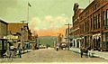
Broadway around 1905
-
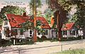
Jacob Abbott's home in 1906
-
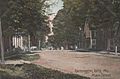
Farmington Falls in 1907
-
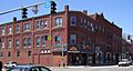
View of downtown Farmington


See also
 In Spanish: Farmington (Maine) para niños
