
Topsham, Maine facts for kids
Quick facts for kids
Topsham, Maine
|
||
|---|---|---|

|
||
|
||

Location of Topsham, Maine
|
||
| Country | United States | |
| State | Maine | |
| County | Sagadahoc | |
| Incorporated | January 31, 1764 | |
| Area | ||
| • Total | 35.59 sq mi (92.18 km2) | |
| • Land | 32.20 sq mi (83.40 km2) | |
| • Water | 3.39 sq mi (8.78 km2) | |
| Elevation | 112 ft (34 m) | |
| Population
(2020)
|
||
| • Total | 6,623 | |
| • Density | 297/sq mi (114.6/km2) | |
| Time zone | Eastern (EST) | |
| • Summer (DST) | EDT | |
| ZIP Code |
04086
|
|
| Area code(s) | 207 | |

Topsham (pronounced TOP-sum) is a town in Sagadahoc County, Maine, United States. It's part of the larger Portland metropolitan area. In 2020, about 9,560 people lived there. Topsham is famous for its yearly Topsham Fair.
Contents
History of Topsham
Early Days and Native Americans
The area where Topsham is now was once called Sawacook. It was home to the Pejepscot Abenaki people, who were a group of Native Americans. They lived and fished near Pejepscot Falls on the Androscoggin River. Sadly, a terrible sickness, likely smallpox brought by Europeans, greatly reduced their population around 1615–1616.
Later, in 1632, the land was given to Thomas Purchase and George Way by the Plymouth Council for New England. Over time, it was bought by different people and eventually by the Pejepscot Company in 1714.
Becoming a Town
The first sawmill was built in 1716 on the Cathance River. In 1717, the settlement was named Topsham, after a town in Devon, England. On January 31, 1764, it officially became a town by order of the Massachusetts General Court.
Early businesses in Topsham included shipbuilding and lumber mills. These lumber mills were very busy between 1750 and 1770. There was also a gristmill (for grinding grain) and a brickyard. The water power from Pejepscot Falls helped run many mills. Industries grew to include factories making doors, window sashes, and stairways, as well as shingle mills, a watch factory, and a pottery maker. There were also factories for nails and pitchforks, two tanneries (for making leather), a tobacco maker, and even feldspar and marble quarries.
In 1856, the Sagadahoc Agricultural & Horticultural Society built its fairgrounds. Topsham still hosts the yearly Topsham Fair today!
Bridges and Floods
In 1756, a toll bridge was built to connect Topsham with Brunswick. This bridge was destroyed by fire in 1842. The bridge used today, called the Frank J. Wood Bridge (also known as "the Green Bridge"), opened in 1932. In 1936, a big flood hit both towns. It damaged the pedestrian "Swing Bridge" and caused the Androscoggin River to flow into the lower parts of the Pejepscot Mill.
The Underground Railroad in Topsham
It is believed that Topsham and Brunswick had "safe houses" that were part of the Underground Railroad. This was a secret network that helped enslaved people escape to freedom. While the Underground Railroad was mostly a secret path, in parts of Brunswick and Topsham, it might have actually been underground!
Some people think there were tunnels made of red brick that connected these safe houses. These tunnels were wide enough for people to walk through easily, and maybe even for a horse and buggy. In Topsham, it's thought that tunnels ran from the Granny-Hole Mill by the Androscoggin River to the Samuel Veazie House. They might have passed through the Charles Thompson House and the Walker Homestead along the way.
The Brunswick and Topsham Water District was created in 1903 to provide water to the towns.
Geography of Topsham
Topsham covers about 35.59 square miles (92.18 square kilometers). Most of this area is land, with about 3.39 square miles (8.78 square kilometers) being water. The town is located next to Merrymeeting Bay where the Androscoggin River flows into it. Other rivers that flow through Topsham include the Cathance River, Little River, and Muddy River.
Major roads like Interstate 295, U.S. Route 201, and state routes 24 and 196 cross through the town. Topsham shares borders with Bowdoin, Bowdoinham, Brunswick, Durham, and Lisbon. The highest point in Topsham is Tate Hill.
Population and People
| Historical population | |||
|---|---|---|---|
| Census | Pop. | %± | |
| 1790 | 826 | — | |
| 1800 | 942 | 14.0% | |
| 1810 | 1,271 | 34.9% | |
| 1820 | 1,429 | 12.4% | |
| 1830 | 1,567 | 9.7% | |
| 1840 | 1,883 | 20.2% | |
| 1850 | 2,010 | 6.7% | |
| 1860 | 1,705 | −15.2% | |
| 1870 | 1,498 | −12.1% | |
| 1880 | 1,544 | 3.1% | |
| 1890 | 1,394 | −9.7% | |
| 1900 | 2,097 | 50.4% | |
| 1910 | 2,016 | −3.9% | |
| 1920 | 2,102 | 4.3% | |
| 1930 | 2,111 | 0.4% | |
| 1940 | 2,334 | 10.6% | |
| 1950 | 2,626 | 12.5% | |
| 1960 | 3,717 | 41.5% | |
| 1970 | 5,022 | 35.1% | |
| 1980 | 6,431 | 28.1% | |
| 1990 | 8,746 | 36.0% | |
| 2000 | 9,100 | 4.0% | |
| 2010 | 8,784 | −3.5% | |
| 2020 | 9,560 | 8.8% | |
| U.S. Decennial Census | |||
Topsham's Population in 2010
According to the 2010 census, there were 8,784 people living in Topsham. There were 3,720 households, and 2,453 families. The town had about 272.8 people per square mile.
Most of the people in Topsham (96.1%) were White. About 0.8% were African American, 0.3% Native American, and 1.3% Asian. About 1.6% of the population was Hispanic or Latino.
In terms of households, 28.6% had children under 18 living with them. About 52.8% were married couples. The average household had 2.32 people, and the average family had 2.81 people. The average age in Topsham was 45.2 years old.
Education in Topsham
Public schools in Topsham are managed by Maine School Administrative District 75.
- There are two elementary schools: Williams-Cone School and Woodside Elementary.
- The middle school is Mt. Ararat Middle School.
- The high school is Mt. Ararat High School.
Places to Visit in Topsham
Famous People from Topsham
Many interesting people have connections to Topsham:
- William A. Ellis: A former member of the Wisconsin Senate.
- Frank Glazer: A talented pianist, composer, and music professor.
- Elijah Kellogg: A minister, lecturer, and author.
- Rebecca Jauch: A state legislator.
- Holman S. Melcher: An officer during the Civil War and a politician.
- Benjamin Orr: A US congressman.
- Benjamin Randall: Another US congressman.
- John Rensenbrink: He helped start the Maine Green Independent Party and the Green Party of the United States.
- Carter Smith: A film director and fashion photographer.
Images for kids
-
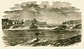
Pejepscot Falls in 1869
-
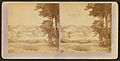
Town view around 1875
-
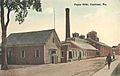
Paper mills around 1912

.jpg)

See also
 In Spanish: Topsham (Maine) para niños
