
Sugarloaf Mountain (Franklin County, Maine) facts for kids
Quick facts for kids Sugarloaf Mountain |
|
|---|---|

Sugarloaf Mountain seen from the AT above Crocker Cirque
|
|
| Highest point | |
| Elevation | 4,237 ft (1,291 m) |
| Prominence | 3,180 ft (970 m) |
| Listing | New England 4000 footers #6 New England Fifty Finest |
| Geography | |

Sugarloaf Mountain
Location in Maine
|
|
| Parent range | Rangeley-Stratton |
| Topo map | USGS Sugarloaf Mountain |
Sugarloaf Mountain is a well-known ski mountain in Carrabassett Valley, Maine. It is the third tallest peak in Maine. Only Mount Katahdin's Baxter and Hamlin peaks are higher. Sugarloaf Mountain is next to Spaulding Mountain on its south side.
Contents
Where is Sugarloaf Mountain Located?
The mountain is in Franklin County, Maine. Water from the northeast and west sides of Sugarloaf flows into the South Branch of the Carrabassett River. This river then joins the Kennebec River, which eventually reaches the Gulf of Maine.
Water from the southeast side of Sugarloaf goes into Rapid Stream. This stream then flows into the West Branch of the Carrabassett River. So, water from the mountain ends up in the ocean!
Exploring the Appalachian Trail Near Sugarloaf
The Appalachian Trail (AT) is a very long hiking path. It stretches about 2,170 miles (3,490 km) from Georgia all the way to Maine. This famous trail passes very close to the top of Sugarloaf Mountain.
Hikers on the AT can take a short side trail, about 0.6 miles (1 km) long, to reach the summit. This side trail and another one on the east side of Sugarloaf were once part of the main AT. However, the AT was later moved to the north side of the mountain, away from the ski slopes.
Skiing at Sugarloaf Mountain
Sugarloaf is a very popular ski resort. It is located on the north side of the mountain. Many people come here to enjoy skiing and snowboarding. It's a major spot for winter sports in Maine.
Images for kids
-
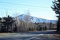
Sugarloaf Mountain ski runs
-
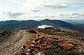
View from Sugarloaf summit
-
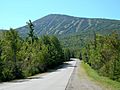
Sugarloaf Mountain seen from Routes 16 and 27


