
Hamlin Peak facts for kids
Quick facts for kids Hamlin Peak |
|
|---|---|
 |
|
| Highest point | |
| Elevation | 4,756 ft (1,450 m) |
| Prominence | 496 ft (151 m) |
| Listing | New England 4000 footers |
| Geography | |

Hamlin Peak
Location in Maine
|
|
| Topo map | USGS Mount Katahdin |
| Climbing | |
| Easiest route | Hike |
Hamlin Peak is an awesome mountain located in Baxter State Park in Piscataquis County, Maine. It stands at 4,756-foot (1,450 m) tall. Hamlin Peak is like a northern shoulder of the huge Mount Katahdin mountain group.
You'll find Baxter Peak to its south and the Howe Peaks to its north. Hamlin Peak is special because it's the second-highest peak in all of Maine!
About Hamlin Peak
Hamlin Peak is part of the amazing Mount Katahdin area. It's located in the wild and beautiful Baxter State Park. This park is a great place for outdoor adventures.
How High Is It?
Hamlin Peak reaches a height of 4,756 feet (about 1,450 meters). It's considered a "four-thousand footer." This means it rises at least 4,000 feet above sea level. It also stands nearly 500 feet (about 150 meters) higher than the low point connecting it to Baxter Peak. This makes it a significant mountain on its own.
Where Does the Water Go?
Rain and snow that fall on the southeast side of Hamlin Peak flow into a place called the Great Basin. From there, the water travels into the Penobscot River. This river is one of Maine's longest. Eventually, all that water makes its way to the Atlantic Ocean at Penobscot Bay. It's cool to think about how water from the top of a mountain can end up in the ocean!
Hiking Hamlin Peak
If you love to hike, you'll be happy to know there are several trails that lead to or near the summit of Hamlin Peak. These trails offer amazing views and a chance to explore the wilderness of Baxter State Park. Hiking is a popular way to reach the top and experience the beauty of this mountain.
Gallery
-
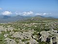
Northwest from Hamlin Peak
-
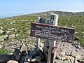
Hamlin Peak
-
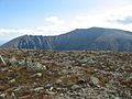
Baxter Peak from Hamlin Peak
-
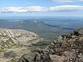
North Basin from Hamlin Peak


