
Penobscot Bay facts for kids
Quick facts for kids Penobscot Bay |
|
|---|---|

Penobscot Bay (Maine)
|
|

Penobscot Bay
Location in Maine
|
|
| Location | Maine, United States |
| Coordinates | 44°11′14″N 68°55′16″W / 44.18722°N 68.92111°W |
| River sources | Penobscot River |
| Ocean/sea sources | Atlantic Ocean |
| Max. depth | 145 m (476 ft) |
| Salinity | approx. 31 psu |
| Settlements | Rockland, Maine Camden, Maine |
Penobscot Bay (which is Baie de Penobscot in French) is a large bay located in the middle of the coast of Maine, in the United States. It's a part of the Atlantic Ocean and the Gulf of Maine. The bay starts where the Penobscot River meets the sea, near the town of Belfast.
Many towns with busy waterfronts are found along Penobscot Bay. These include Rockland, Rockport, Stonington, and Belfast. Penobscot Bay is located between Muscongus Bay and Blue Hill Bay, and it's just west of Acadia National Park.
Contents
A Look Back in Time
About 11,000 years ago, at the start of the Holocene period, the sea level in the Gulf of Maine was much lower. It was about 180 feet (55 meters) below where it is today. At that time, Penobscot Bay was actually a continuation of the Penobscot River. The river flowed through a wide, flat area that stretched out past what is now Matinicus Island.
The Penobscot Nation
Penobscot Bay and the Penobscot River are named after the Penobscot Indian Nation. This group of Native Americans has lived in the area for over ten thousand years. They have always fished, hunted, and gathered shellfish in and around the bay and river.
The Penobscot Indian Nation is part of the Wabanaki Confederacy. Their current reservation includes Indian Island, which is north of Orono, Maine. It also includes all the islands in the Penobscot River above Indian Island. Scientists have found ancient remains of their campsites on the bay's shores and islands. These sites show that people lived there thousands of years ago.
A Revolutionary War Battle
Penobscot Bay was also the site of a difficult defeat for the Americans during the American Revolutionary War. In 1779, the British captured part of Maine and built forts near the bay. They called this new territory New Ireland.
To get the land back, the Continental Navy sent a large group of ships. This group included 19 warships and 25 support vessels. They arrived on July 24, 1779. However, the American commanders, Solomon Lovell and Dudley Saltonstall, disagreed on how to attack. This caused delays in their plans.
On August 13, a stronger British fleet arrived, led by George Collier. Facing a much larger enemy force, the American fleet had to flee. They beached their ships and set them on fire to prevent the British from capturing them. All 44 American ships were either destroyed or captured. This was America's worst naval defeat until the attack on Pearl Harbor 162 years later.
Islands and Summer Homes
Penobscot Bay has many islands. Some of these islands are home to famous summer communities. People from all over the country come to these islands for their summer vacations.
Protecting Penobscot Bay
Since the 1800s, Penobscot Bay has received sewage and waste from towns and factories. For a long time, the main way to deal with this waste was to let the bay's large amount of water dilute it.
In the mid-1900s, the United States government started to require better ways to control water pollution. The first step was the Federal Water Pollution Control Act of 1948. This law asked states to create and enforce their own pollution rules.
Later, in 1972, the law was greatly expanded. It became known as the Clean Water Act. This act required projects to meet many federal standards for clean water.
Cleaning Up the Bay
In 1966, officials in Maine closed shellfish beds in parts of Penobscot Bay. This was because the water was too polluted. The US Department of the Interior then studied the pollution.
In 1967, they released a report. It found that sewage from eleven towns and waste from thirteen businesses were the main sources of pollution. The report said that this pollution was hurting the economy. People could not sell shellfish from the bay because the water was not clean enough.
The report suggested specific water quality rules for those causing pollution. It said that if these sources improved their waste treatment, the bay's waters would be clean again. This would allow for commercial and recreational fishing, swimming, and other activities.
Penobscot Bay Fisheries
Early Lobster Fishing
Penobscot Bay was one of the first places in Maine where people started fishing for lobster on a large scale. This began in the 1840s.
One report from 1899 tells us about these early days. In 1848, a Captain Oakes started buying lobsters from the Penobscot Bay area. He would then take them to Boston to sell. Lobsters were so plentiful back then that just four men could catch enough for Captain Oakes's boat every trip. Each man could catch between 1,200 and 1,500 lobsters in about ten days.
Another fisherman, Captain S. S. Davis, said that around 1864, three men could catch enough lobsters to fill his boat. He could load 5,000 lobsters at a time. This shows how many lobsters were in the bay during those early years.
Lobster fishing also started in other parts of the bay around this time. It began at North Haven in 1848 and at Matinicus Island in 1868. The business grew quickly, especially after a lobster canning factory opened in Oceanville around 1860.
Islands in Penobscot Bay
- Isle au Haut
- Islesboro
- North Haven
- Vinalhaven
- Matinicus Isle
- Criehaven
- Sears Island
- Great Spruce Head
- Nautilus Island
- Little Deer Isle
- Deer Isle (Deer Isle, Stonington, Mountainville, Sunrise, Sunset)
Towns along the Western Side

- Saint George
- South Thomaston
- Owls Head
- Rockland
- Rockport
- Camden
- Lincolnville
- Northport
- Belfast
- Searsport (Penobscot Marine Museum)
- Stockton Springs
- Prospect
- Verona Island
Towns on the Eastern Side
Images for kids
-
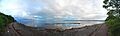
A 180° panorama of the Penobscot Bay from near the Belfast/Searsport town line looking SE. Belfast Bay is to the right, Northport on the peninsula, Islesboro on the center horizon, Castine to the left of that, and toward Stockton Springs and the entrance to the Penobscot River are beyond the trees on the far left.
See also
 In Spanish: Bahía de Penobscot para niños
