
Searsport, Maine facts for kids
Quick facts for kids
Searsport, Maine
|
|
|---|---|

Street in Searsport. The Penobscot Marine Museum is across the street.
|
|

Location of the town of Searsport (in yellow) in Waldo County and the state of Maine.
|
|
| Country | United States |
| State | Maine |
| County | Waldo |
| Incorporated | 1845 |
| Area | |
| • Total | 42.53 sq mi (110.15 km2) |
| • Land | 28.65 sq mi (74.20 km2) |
| • Water | 13.88 sq mi (35.95 km2) |
| Elevation | 236 ft (72 m) |
| Population
(2020)
|
|
| • Total | 2,649 |
| • Density | 92/sq mi (35.7/km2) |
| Time zone | UTC-5 (Eastern (EST)) |
| • Summer (DST) | UTC-4 (EDT) |
| ZIP code |
04974
|
| Area code(s) | 207 |
| FIPS code | 23-66635 |
| GNIS feature ID | 0582716 |
| Website | www.searsport.maine.gov |
Searsport is a town in Maine, United States. It is a deep water seaport located where the Penobscot River meets Penobscot Bay. The town is near Sears Island and Cape Jellison in Waldo County.
In 2020, about 2,649 people lived there. Searsport is famous as "the home of the famous sea captains." It is also known as the "Antique Capital of Maine." The town includes a small area called North Searsport.
Contents
History of Searsport
Searsport was first settled in the 1760s. It officially became a town on February 13, 1845. Parts of the towns of Prospect and Belfast were used to create Searsport.
In 1747, a big fire destroyed the Province House in Boston. General Samuel Waldo wanted to move the capital of Massachusetts to Searsport. He had bought land in this area around 1720. His idea did not happen.
The town was named after David Sears of Boston. He agreed to give a lot of money to help start the town.
Searsport's Maritime Past
Searsport has a very rich history connected to the sea. During the 1800s, the town was a major shipbuilding center. It had 17 shipyards and built 200 ships.
Searsport also provided many deep water captains for the nation's merchant ships. About one-tenth of all deep water captains came from Searsport. You can learn more about this history at the Penobscot Marine Museum.
Searsport's Important Port
Searsport is Maine's second largest deep water port. This means it has a harbor deep enough for large ships. It is a good location because it connects to railroads and areas that produce wood products.
In 1905, the Northern Maine Seaport Railroad opened. It connected Searsport to the Bangor and Aroostook Railroad. This allowed products like potatoes and timber to be shipped from Searsport by boat. The railroad also brought coal to Searsport for its locomotives.
Port Features
Searsport harbor is a safe place for ships to anchor. It is about 2 by 3 miles (3 by 5 km) wide. The water is about 40 feet (12 meters) deep at low tide. The tide usually changes by about 10 feet (3 meters).
The railroad pier is 800 feet (244 meters) long and 100 feet (30 meters) wide. It has conveyor belts to move bagged cargo. There are tracks on the pier for many railcars. Another pier, Sprague pier, is 614 feet (187 meters) long.
During World War II, the port in Searsport was an important place for loading ammunition.
Geography of Searsport
Searsport covers a total area of about 42.53 square miles (110.15 square kilometers). Most of this area, about 28.65 square miles (74.20 square kilometers), is land. The rest, about 13.88 square miles (35.95 square kilometers), is water.
The town is located on Penobscot Bay. Two small streams, Long Cove Brook and Mill Brook, flow through the town. Searsport also includes Sears Island, which is about 940 acres (3.8 square kilometers) in size.
Nearby Towns and Roads
Major roads like U. S. Route 1 and Maine State Route 3 pass through Searsport.
Searsport shares its borders with several other towns:
- Prospect and Stockton Springs to the northeast.
- Belfast to the southwest.
- Swanville to the northwest.
- Frankfort to the north.
Population Information
| Historical population | |||
|---|---|---|---|
| Census | Pop. | %± | |
| 1850 | 2,208 | — | |
| 1860 | 2,532 | 14.7% | |
| 1870 | 2,282 | −9.9% | |
| 1880 | 2,322 | 1.8% | |
| 1890 | 1,693 | −27.1% | |
| 1900 | 1,349 | −20.3% | |
| 1910 | 1,444 | 7.0% | |
| 1920 | 1,373 | −4.9% | |
| 1930 | 1,414 | 3.0% | |
| 1940 | 1,319 | −6.7% | |
| 1950 | 1,457 | 10.5% | |
| 1960 | 1,838 | 26.1% | |
| 1970 | 1,951 | 6.1% | |
| 1980 | 2,309 | 18.3% | |
| 1990 | 2,602 | 12.7% | |
| 2000 | 2,641 | 1.5% | |
| 2010 | 2,615 | −1.0% | |
| 2020 | 2,649 | 1.3% | |
| U.S. Decennial Census | |||
In 2010, there were 2,615 people living in Searsport. There were 1,186 households, which are groups of people living together. About 715 of these were families.
Most of the people in Searsport were White (97.2%). A small number were African American, Native American, or Asian. About 0.9% of the population was Hispanic or Latino.
The average age of people in Searsport was 46.9 years old. About 19% of residents were under 18 years old. About 19% were 65 years or older.
Notable People from Searsport
Many interesting people have connections to Searsport:
- Phineas Banning Blanchard – A sea captain and leader in the shipping industry.
- Henry Chadwick – A well-known journalist.
- Joanna Carver Colcord – A writer and a pioneer in social work.
- Roswell K. Colcord – The 7th governor of Nevada; he was born in Searsport.
- Lincoln Ross Colcord – An author and journalist.
- Peter A. Garland – A US congressman and town manager of Searsport.
- Sam Houston – A bodyguard for George Washington.
- Matthew Kenney – A famous chef who grew up in Searsport.
- Freeman McGilvery – An army officer.
- Marlboro Packard – A master shipbuilder.
- Ephraim K. Smart – A US congressman; he was born in Searsport.
- Frederick Stevens – A US representative from Minnesota; he grew up in Searsport.
Places to Visit in Searsport
- Moose Point State Park
- Sears Island
- Union School
- Penobscot Marine Museum
- Cape Jellison
Images for kids
-
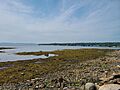
Searsport harbor in Maine
-
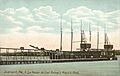
A six-masted schooner around 1908
-

Mack Point cargo terminal rail yard
-
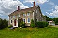
A typical 19th-century Searsport sea captain's house (built 1840)


See also
 In Spanish: Searsport (Maine) para niños
